1860 Philips Folding or Pocket Map of England and Wales
England-phillips-1860$370.00
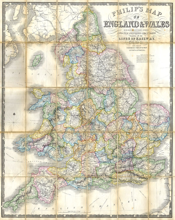

Title
Philips’ Travelling Map of England
1860 25 x 31 in (63.5 x 78.74 cm)
1860 25 x 31 in (63.5 x 78.74 cm)
Description
This is an impressive folding pocket map of England and Wales by the venerable English map publishing firm of George Philip. Formally titled, 'Philips' Travelling Map of England.' Produced under the editorial management of Professor William Hughes (1817-1876). Presented on 30 beautifully hand colored panels mounted on linen.
Cartographer
George Philip (1800 - 1882) was a map publisher and cartographer active in the mid to late-19th century. Philip was born into a Calvinst family in Huntly, Aberdeenshire, Scotland. Around 1819 he apprenticed himself to William Grapel, a Liverpool printer and bookseller. Fifteen years later, in 1834, Philip founded his own Liverpool book and map firm. Philip's earliest cartographic ventures were mostly educational material issued in tandem with John Bartholomew Sr., August Petermann, and William Hughes. In 1848, Philip admitted his son, George Philip Jr. (1823 - 1902) into the firm, renaming it George Philip and Son Ltd. George Philip Jr. ran the firm until his death in 1902, by which time it had developed into a major publishing concern. His successors established the London Geographical Institute, a factory where they embraced modern printing techniques to produce thousands of economical and high quality maps. In April 1988, George Philip & Son was acquired by Octopus Publishing, a branch of Reed International. Nonetheless, today the firm trades and publishes to this day as George Philip and Son. More by this mapmaker...
Condition
Very good condition. Disected and mountedon linen.