1752 Buache Map of the Sea Floor of the English Channel
EnglishChannel-buache-1752$750.00

Title
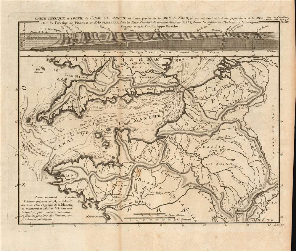
Carte physique et profil du canal de la Manche et d'une partie de la Mer du Nord...
1752 (dated) 10 x 12.75 in (25.4 x 32.385 cm) 1 : 2902000
1752 (dated) 10 x 12.75 in (25.4 x 32.385 cm) 1 : 2902000
Description
This is a beautiful, rare 1752 Philippe Buache map of the English Channel, showing the coast of France (from the mouth of the Loire to the Low Countries and the mouth of the Rhine) and the entire southern coast of England. The map includes depth soundings for the Channel, and is accompanied by a cross-section chart of the whole of the Channel comparing the 'supposed' depth of the Channel with its actual, measured depth. The map is notable for its early use of isobaths - lines showing depth contours of the ocean floor. Although not the first appearance of this technique (likely this was Luigi Ferdinando Marsigli's 1725 map of the Gulf of Lion), Buache's is among the first acquirable maps demonstrating the technique.
Early Presentation of Buache's System of Oceanographic Mapping
A note on the map indicates that it was initially presented by Buache in manuscript to the French Royal Academy in 1737 along with another 'of the ocean to the Equator, to show how were the junctions of the lands, either near or distant.' This appears to be an early exploration of the ideas that Buache would later publish in 1752 to accompany this map. The associated essay (not included), Essai de Géographie Physique, argued that the Earth's great river basins are defined by major mountain ranges, many of which he believed extended beneath the oceans. While his theories were sufficiently far-reaching to necessitate the invention of many undersea mountain ranges (some of which he deduced mathematically!) to support his theory, his initial approaches to the topic appear to have been based on extremely concrete measurement, such as evidenced by this map's exacting depiction of the floor of the Channel. Buache's innovative ideas enthralled many Parisian intellectuals, and Buache was admitted into the Royal Academy of Sciences the same year this map and the associated essay were published.Publication History and Census
This map was printed for inclusion in the 1752 edition of Histoire de l'Académie royale des sciences. We see eight examples of that volume catalogued in institutional collections. The separate map is listed only in the collection of the Bibliotheque Nationale de France.Cartographer
Phillipe Buache (February 7, 1700 - January 24, 1773) was a late 18th century French cartographer and map publisher. Buache began his cartographic career as the workshop assistant and apprentice to the important and prolific cartographer Guillaume de L'Isle. Upon De L'Isle's untimely death, Buache took over the publishing firm cementing the relationship by marrying De L'Isle's daughter. Over the years, Bauche republished many of De L'Isle's maps and charts. Buache was eventually appointed Premier Geographe du Roi, a position created-for and previously held by Guillaume de L'Isle. Buache is most respected for his introduction of hachuring as a method from displaying underwater elevation on a two dimensional map surface. Buache compiled maps based upon geographic knowledge, scholarly research, the journals of contemporary explorers and missionaries, and direct astronomical observation. Nevertheless, even in 18th century Paris geographical knowledge was severely limited - especially regarding those unexplored portions of the world, including the poles, the Pacific northwest of America, and the interior of Africa and South America. In these areas the Buache, like his primary rival Robert de Vaugondy, must be considered a speculative geographer or 'positive geographer'. Speculative geography was a genre of mapmaking that evolved in Europe, particularly Paris, in the middle to late 18th century. Cartographers in this genre would fill in unknown areas on their maps with speculations based upon their vast knowledge of cartography, personal geographical theories, and often dubious primary source material gathered by explorers and navigators. This approach, which attempted to use the known to validate the unknown, naturally engendered many rivalries. Buache's feuds with other cartographers, most specifically Didier Robert De Vaugondy, resulted in numerous conflicting papers being presented before the Academie des Sciences, of which both were members. The era of speculatively cartography effectively ended with the late 18th century explorations of Captain Cook, Jean Francois de Galaup de La Perouse, and George Vancouver. Buache was succeeded by his nephew Jean-Nicholas Buache de Neuville. More by this mapmaker...
Source
Académie des sciences (France), Histoire de l'Académie royale des sciences (Paris, 1752), Imprimerie royale.
Condition
Very good condition. Original folds, some creasing and areas of toning. Else excellent.
References
OCLC 494248373.