This item has been sold, but you can get on the Waitlist to be notified if another example becomes available, or purchase a digital scan.
1882 U.S.C.G.S. Chart or Map of the Entrance to Pensacola Bay, Florida
EntrancePensacolaBay-uscgs-1882$525.00

Title
Entrance to Pensacola Bay Florida.
1882 (dated) 26.25 x 32.5 in (66.675 x 82.55 cm) 1 : 30000
1882 (dated) 26.25 x 32.5 in (66.675 x 82.55 cm) 1 : 30000
Description
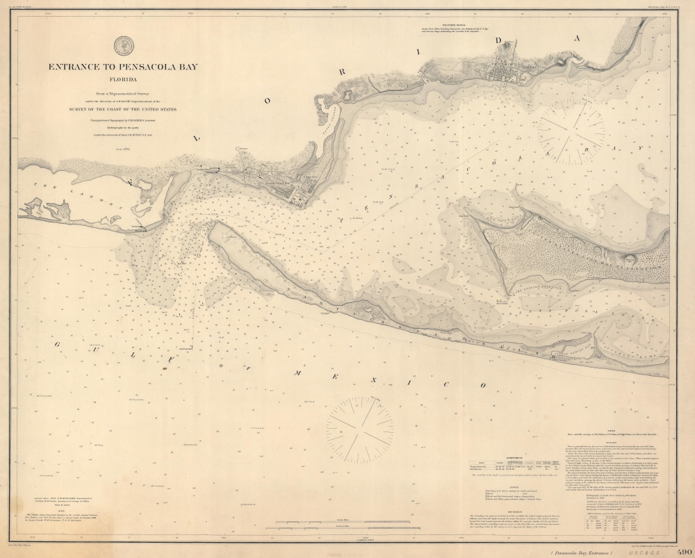
This is an 1882 U.S. Coast and Geodetic Survey nautical map of the entrance to Pensacola Bay, Florida.
A Closer Look
The map depicts from The Lagoon northeast along the coast past Emanuel Point. Pensacola, Newtown, Woolsey, and Warrington are illustrated. The U.S. Navy Yard, the Naval Hospital, and the U.S. Barracks in the vicinity of Warrington are named, along with Fort San Carlos de Barrancas and Fort McRae. Santa Rosa Island separates Pensacola Bay from the Gulf of Mexico. Depth soundings fill Pensacola Bay, Santa Rosa Sound, and most of the Gulf of Mexico.The United States Live Oak Plantation
Today known as the Naval Live Oaks Reservation, the U.S. government purchased what was then known as the Deer Point Plantation in 1828 as the first federal tree farm. Operations began on January 18, 1829, to supply the U.S. Navy with live oaks (Quercus virginiana) for shipbuilding. These gnarled crooked trees produced exceptionally strong wood ideally suited or the main curved structural supports for ship hulls and decking. The USS Constitution earned her nickname 'Old Ironsides' during the War of 1812 because of the strength of her live oak frame. Other famous U.S. Navy vessels built with live oaks include the USS Constellation and the USS Hancock, an American revolutionary war privateer. As iron and steel became the standard material in ship construction, the use of live oaks diminished. However, during the 1926 restoration of the USS Constitution, live oaks from the Pensacola area were used. On January 8, 1971, the Naval Live Oaks Reservation became part of the Gulf Islands National Seashore, and was included on the U.S. National Register of Historic Places on September 28, 1998.Publication History and Census
This map was drawn by P. Witzel, engraved by G.B. Metzeroth, J.V.N. Throop, and A. Petersen, and published by the U.S. Coast and Geodetic Survey in June 1882. This is the only known cataloged example of the present 1882 edition. We note an example of the 1877 edition in the Library of Congress and an example of the 1892 edition in the collection at the University of Chicago.CartographerS
The Office of the Coast Survey (1807 - present) founded in 1807 by President Thomas Jefferson and Secretary of Commerce Albert Gallatin, is the oldest scientific organization in the U.S. Federal Government. Jefferson created the "Survey of the Coast," as it was then called, in response to a need for accurate navigational charts of the new nation's coasts and harbors. The spirit of the Coast Survey was defined by its first two superintendents. The first superintendent of the Coast Survey was Swiss immigrant and West Point mathematics professor Ferdinand Hassler. Under the direction of Hassler, from 1816 to 1843, the ideological and scientific foundations for the Coast Survey were established. These included using the most advanced techniques and most sophisticated equipment as well as an unstinting attention to detail. Hassler devised a labor intensive triangulation system whereby the entire coast was divided into a series of enormous triangles. These were in turn subdivided into smaller triangulation units that were then individually surveyed. Employing this exacting technique on such a massive scale had never before been attempted. Consequently, Hassler and the Coast Survey under him developed a reputation for uncompromising dedication to the principles of accuracy and excellence. Unfortunately, despite being a masterful surveyor, Hassler was abrasive and politically unpopular, twice losing congressional funding for the Coast Survey. Nonetheless, Hassler led the Coast Survey until his death in 1843, at which time Alexander Dallas Bache, a great-grandson of Benjamin Franklin, took the helm. Bache was fully dedicated to the principles established by Hassler, but proved more politically astute and successfully lobbied Congress to liberally fund the endeavor. Under the leadership of A. D. Bache, the Coast Survey completed its most important work. Moreover, during his long tenure with the Coast Survey, from 1843 to 1865, Bache was a steadfast advocate of American science and navigation and in fact founded the American Academy of Sciences. Bache was succeeded by Benjamin Pierce who ran the Survey from 1867 to 1874. Pierce was in turn succeeded by Carlile Pollock Patterson who was Superintendent from 1874 to 1881. In 1878, under Patterson's superintendence, the U.S. Coast Survey was reorganized as the U.S. Coast and Geodetic Survey (C & GS) to accommodate topographic as well as nautical surveys. Today the Coast Survey is part of the National Oceanic and Atmospheric Administration or NOAA as the National Geodetic Survey. More by this mapmaker...
Julius Erasmus Hilgard (January 7, 1825 - May 9, 1890) was a German-American engineer and Director of the United States Coast Survey. Born in Zweibrüken, Rhenish Bavaria, he and his family emigrated to the United States in 1835. They arrived in New Orleans on Christmas Day and traveled from there to a farm in Belleville, Illinois. Hilgard went to Philadelphia in 1843 to study engineering. It was in Philadelphia that Hilgard met Professor Alexander Bache, the recently appointed Superintendent of the United States Coast Survey. In 1845, Bache gave Hilgard a position with the Coast Survey, although his official appointment was delayed for some reason until December 28, 1846. Hilgard worked with the Coast Survey off and on for the rest of his life. At the outbreak of the Civil War, Hilgard was engaged in a prominent business enterprise in Paterson, New Jersey, but Bache convinced him to return to the Coast Survey to supplement in the war effort. In 1862, Hilgard 'assumed charge of the Coast Survey office', taking on the duties of Superintendent in lieu of Bache, who had, by this time, become extremely ill. Upon Bache's death in 1867, Hilgard became the de-facto Superintendent as well as the assistant in charge of the office. He served as such until February 1867 when Benjamin Pierce was appointed Superintendent. Hilgard continued to work for the Coast Survey under Pierce as 'assistant in charge of office' until he was formally appointed Superintendent in 1881, a position he held until 1885 when he was forced to resign due to illness. He died 5 years later. Learn More...
G.B. Metzeroth (fl. c. 1852 - 1863) was a German-born engraver. He worked for the U.S. Coast Survey from 1856 until at least 1863. Learn More...
A. Petersen (fl. c. 1857 - c. 1875) was an engraver for the U.S. Coast Survey and then the U.S. Coast and Geodetic Survey. Learn More...
Condition
Very good. Light toning. Light edge wear.
References
Library of Congress G3932.P45P5 1877 .U5 1977 (1877 edition). University of Chicago G3701.P5 svar .U4 no.490 1892 (1892 edition).