1892 G. Lang Wall Map of the World on Mercator Projection
Erdkarte-lang-1892$1,100.00

Title
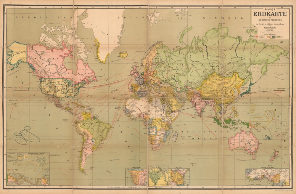
G. Lang's Erskarte in Merkators Projection.
1892 (dated) 43.75 x 66.75 in (111.125 x 169.545 cm) 1 : 17900000
1892 (dated) 43.75 x 66.75 in (111.125 x 169.545 cm) 1 : 17900000
Description
An impressive first-edition wall map of the world was issued in 1892 by the Leipzig publisher Georg Lang. The map features a unique manuscript record of an epic around-the-world journey.
A Closer Look
Centered on Europe, the map employs a Mercator projection to illustrate the world. Political entities are defined with color coding. Red overprinting illustrates maritime routes and rail networks. Insets along the bottom of the map detail primary German colonial holdings: Togoland, Cameroon (Kamerun), East Africa (Tanzania), the Nile Delta, southwest Africa (Namibia), and the Melanesian archipelago.An Incredible Odyssey
The map includes manuscript annotation chronicling an epic around-the-world voyage beginning in San Francisco and finishing in New York. The unknown but adventurous traveler set off from San Francisco on October 17 or 18th, crossing the Pacific on the San Francisco-Yokohama Line, disembarking in Japan on November 2. He traveled overland through Japan before setting sail from Nagasaki to Hong Kong, from which he visited Canton (Guangzhou). From this port, he sailed south for Singapore, then Penang, then Colombo. He moved on to Pondicherry and Calcutta before heading inland by train along the Ganges Line to Agra, where he visited the Taj Mahal, Delhi, and Bombay. The voyage continued by sea to Aden, then through the Red Sea and the Suez Canal into the Mediterranean. The adventurer next lands in Italy, from where he begins a Grand Tour of Europe, passing through Austria, Switzerland, Germany, and France before returning to Genoa. From there, he catches a steamer to Gibraltar, breaking for a detour to Madrid. He then visits Lisbon, travels extensively in the British Isles, and detours to Calais and Amsterdam. What follows is an astonishing voyage to the northernmost point in Norway, Kinnarodden. Returning south, he boards a steamer on the Liverpool-New York Line. The traveler stopped dating his voyage in Japan, so we do not know how long the entire trip took, nor do we know in what year/s it was accomplished, but we are nonetheless impressed.Publication History and Census
There are at least two editions of this map, 1892 and 1902. The first edition (as here) was copyrighted in Leipzig in 1892 and approved for use at schools by ministerial decree on May 18, 1893. This map is uncommon. We have identified one example of this edition at the Bayerische Staatsbibliothe (Bavarian State Library) and a 1902 edition at the British Library. No known history of another example on the private market.CartographerS
Georg Lang (f. 1892 - 1949) was a German map publisher active in Leipzig in the late 19th and first half of the 20th centuries. He is known for his impressive wall maps and diagrams published for schoolroom and general educational use. Lang exhibited along with Justus Perthes and Carl Flemming at the German Publisher booth at the 1893 Chicago Columbian Exposition. His cartographic work is often associated with the cartographer Eduard Gaebler (1842 - 1911). At some point he became associated with Hilmar Klasing and Co., a major cartographic firm. More by this mapmaker...
Friedrich Eduard Gaebler (January 22, 1842 - November 8, 1911) was a German cartographer, engraver, publisher and lithographer based in Leipzig. Gabler was born in Pegau, Saxony, Germany. After receiving a basic education, he produced to master engraving and mapmaking at the Leipzig school of Albert Henry Payne. He worked with his brother, Rober Gaebler to develop a zincography-based pantatype printing process ideal for map work. In 1866 he established an institute for geographic studies, which he managed until 1874, when he took over George Westermann's (1810 - 1879) geographical institute. Westermann died in 1879 and Gaebler took over his geographical business, founding Eduard Gaeblers Geographisches Institut on December 5, 1879. He became successful providing top quality engraving and geographical work for a variety of publishers including Georg Lang and Carl Kiercke. When he died in 1911, the firm was taken over by his sons and remained active until 1935, when it declared bankruptcy. In 1941, the remains of the firm were acquired by the Deutschen Zentraldruckerei AG, which itself shut down in 1945. Learn More...
Condition
Very good. Some toning along old fold lines. Dissected and mounted on linen. Original linen reinforced in places, but generally stable. Minor regular perforations in margin - possibly intended for hanging.
References
OCLC 163311603.