This item has been sold, but you can get on the Waitlist to be notified if another example becomes available, or purchase a digital scan.
1588 Livio and Giulio Sanuto Map of the African Red Sea Coast
Eritrea-sanuto-1588$1,750.00

Title
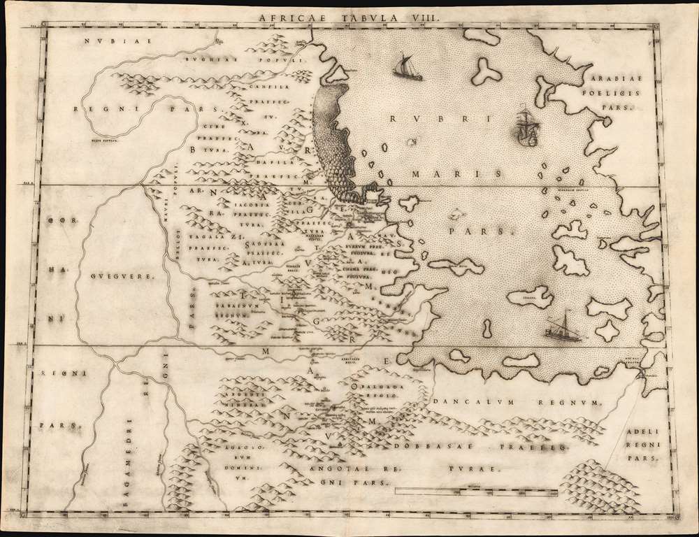
Africae Tabula VIII.
1588 (undated) 15.25 x 20.75 in (38.735 x 52.705 cm) 1 : 3704000
1588 (undated) 15.25 x 20.75 in (38.735 x 52.705 cm) 1 : 3704000
Description
This elegant map of the Upper Nile and the Red Sea was printed in a single edition in 1588 for Livio and Giulio Sanuto's twelve-sheet 'atlas' of Africa. It is the first detailed and reasonably accurate map of what is today Eritrea, Djibouti, Ethiopia, and Sudan. While the general outline of Sanuto's map superficially resembles the 1564 Gastaldi Il disegno della geografia moderna de tutta la parte dell'Africa, its detail diverges sharply from that source, and any other contemporaneous map. This map thus represents a thorough reconsideration of African geography in the light of both conventional and newly available sources - marking it as a unique and underappreciated masterpiece of geographical thought.
Both topographically and toponomically, Sanuto's map diverges sharply from all precursors and contemporaries. While frequently drawn from common sources, Sanuto does not copy Gastaldi in their placement. Moreover, despite most sources associating Ethiopia with Prester John, Sanuto pointedly avoided the error.
The First Visit to Eritrea, Recorded
The map centers on the lands of Medri Bahri, and the Tigray, mainly as reported by the Portuguese explorer Francisco Álvares in 1520 - the first European to document the region. The Eritrean highlands, between the Red Sea and the Mereb River (here Latinized Marabus fluvius) was known as Ma'ikele Bahr (between the seas/rivers). The map also reflects Álvares' observation of the ancient kingdom of Axum. This was an important frontier region, warred over constantly in the 15th and 16th century between the Ethiopian and Ottoman Empires. That history is evident in the diverse toponomy. For example, the island Suachena corresponds to the modern city, Suakin. The city changed hands several times between Ethiopia, their Portuguese allies, and the Ottomans. When Álvares visited, it was the seat of regional Ottoman authority. Also shown is the port of Arkiko, according to by Álvares, the only Ethiopian port. Between Suakin and Arkiko is a great forest: Xumetae Nemus. Álvares described this, noting that while the forest itself was vast, the trees were not valuable - likely mangrove forests, which still populate the region.Kings of the Sea
The name 'Barnagas' - applied to the lands just inland from the mangrove forest - referred to a ruler named Bahr Negash (Barnagas), meaning 'King of the Sea.' The name first appears in the mid-fifteenth century under the reign of Emperor Zara Yaqob (r. 1433 - 1468), who reconquered the region on behalf of the Ethiopian Empire. The term was still in use during Álvares' 1520 visit. The Kings of the Sea fought on behalf of either Abyssinia or the Adal Sultanate, depending on the political climate, sometimes representing the Christian front against Muslim power, and sometimes making common cause with the Ottomans.Kingdom of Tigray
The lands south of the Mereb River were under the control of the Ethiopian tributary Tigray Mekonen (Lord of Tigray). Most notable throughout this area are a profusion of churches and settlements running in a chain from the port of Arkiko to the south, ultimately connecting to the center of the Ethiopian Empire. These reflect Álvares' path as he traveled, and represent the best cartographic interpretation we have of a sixteenth century European visit to Eritrea and northern Ethiopia. It is not surprising that there should be good detail for Tigray. The Portuguese established a colony there as afoothold for the Cristóvão da Gama's campaign against the Adal Sultanate (1541 - 1543).The Ancient Ethiopian Empire of Axum
This region, in antiquity, was the heart of the Axumite Kingdom, here noted as Chaxumum. By the time Álvares visited, the center of power had long since passed south to Amhara, but Tigray remained notable for its historic churches, many of which are here named.Northern Extent of the Kingdom of Prester John
This region represented the north part of an area where many contemporary cartographers - notably Gastaldi and Ortelius - placed the apocryphal Kingdom of Prester John. Sixteenth century explorers describing Ethiopia typically referred to the Emperor as Prester John, to the bafflement of the emperors themselves who insisted the name was not used. Virtually all European explorers to report on eastern Africa used the term: Leo Africanus, Francisco Álvares, and Duarte Barbosa, among others. Geographers such as Gastaldi, Ortelius and their copyists followed suit.Both topographically and toponomically, Sanuto's map diverges sharply from all precursors and contemporaries. While frequently drawn from common sources, Sanuto does not copy Gastaldi in their placement. Moreover, despite most sources associating Ethiopia with Prester John, Sanuto pointedly avoided the error.
A Bright Light, Dimmed
As published, Sanuto's work was the first such book dedicated solely to Africa. This was not the author's intent, as the work was but one volume of a twelve-volume global geography. If Sanuto were to have applied the same fresh thought to other regions that he applied to Africa, the result would certainly have been an atlas to eclipse that of Ortelius. As it happened, Livio died in 1576 before producing the other volumes, likely a victim of the plague. The completed volume - the set of Africa maps - was published posthumously in 1588, in a single edition. Thus, despite the detail and beauty of Sanuto's Africa maps, they achieved scant recognition. Dutch Golden Age mapmakers instead copied Ortelius's less refined mapping. Improved maps of the Upper Nile did not appear until the 1670s and 80s, with the work of Du Val, Ludolf, and Coronelli. Of Sanuto's work, Bifolco and Ronca offer high praise:...The description of Africa is the best of the sixteenth century and the maps represent a happy synthesis of all the elements then available; hence it is legitimate to conclude that if Sanuto had succeeded in completing the entire work, we would have in it one of the greatest monuments of geography in the period of the Renaissance.
Publication History and Census
This map was composed by Livio Sanuto, and engraved by his brother Giulio for inclusion in their Geografia di M Livio Sanuto Distinta in XII Libri, of which only the Africa volume was published. It is not known when exactly the plates for the Geografia were engraved, but it is thought that Livio prepared the text for the work between 1561 and 1575. Livio died in 1576. The work was published posthumously in 1588 by Damiano Zenaro. We see only one example of this separate map in OCLC, cataloged by the Biblioteca Nacional de España. The complete atlas appears to be reasonably well represented in institutional collections.CartographerS
Livio Sanuto (1520 – 1576) was a Venetian cartographer and scientific instrument maker produced, with his engraver brother, Giulio (fl. 1540-1588) – an array of some of the most important geographical works produced in Venice during the second half of the sixteenth century. These included a 27-inch globe and the 1588 12-sheet atlas, Geografia della Africa. Among Livio and Giulio's works were some, if not all of the maps prepared for Ruscelli's 1561 Ptolemy. More by this mapmaker...
Giulio Sanuto (fl. 1540 – 1580) was a Venetian engraver. He was born the illegitimate son of Cavaliere Francesco di Angelo Sanuto; With his brother, the cartographer and scientific instrument maker Livio Sanuto (1520 – 1576) he produced an array of some of the most important geographical works produced in Venice during the second half of the sixteenth century. These included a 27-inch globe and the 1588 12-sheet atlas, Geografia della Africa. Giulio's career is singluar among Venice's engraves in that it appears to have been equally based on artistic, figurative work as well as his cartographic works. Giulio is more broadly known for a small but sought-after selection of decorative engravings; no more than twelve of these can be attributed confidently to him, including the monumental Apollo and Marsyas, measuring over 1.30 meters wide. Whilst Sanuto's engravings were generally based upon the designs of other artists, his work was both ambitious and grand, and he often signed these works. Learn More...
Source
Sanuto, L., Geografia di M Livio Sanuto Distinta in XII Libri, (Venice: Zenaro) 1588.
Condition
Very good; some warping of sheet, else excellent. An untrimmed example with a bold strike.
References
Not in Afriterra. OCLC 796358730. Norwich, O. Maps of Africa cf 304. Bifolco, S. / Ronca, F. Cartografia e Topografia Italiana del XVI Secolo. pp. 2525-6.