This item has been sold, but you can get on the Waitlist to be notified if another example becomes available, or purchase a digital scan.
1588 Livio and Giulio Sanuto Map of East Africa and the Ethiopian Empire
Ethiopia-sanuto-1588$2,100.00

Title
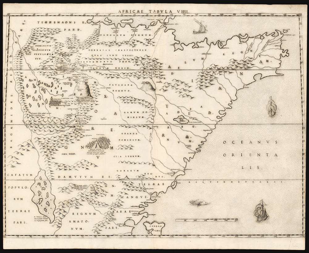
Africae Tabula VIIII.
1588 (undated) 15.5 x 20.75 in (39.37 x 52.705 cm) 1 : 5192000
1588 (undated) 15.5 x 20.75 in (39.37 x 52.705 cm) 1 : 5192000
Description
This elegant map of East Africa was printed in a single edition in 1588 for Livio and Giulio Sanuto's twelve-sheet 'atlas' of Africa. This map represents a thorough reconsideration of African geography in the light of both conventional and newly available sources. Due to superficial similarities, some have suggested that Sanuto's geography is derived from Gastaldi's seminal 1564 Il disegno della geografia moderna de tutta la parte dell'Africa. This is not the case, as this and the other maps from the Sanuto atlas diverged sharply any contemporaneous or prior map - marking it as a unique and underappreciated masterpiece of geographical thought.
Both topographically and toponomically, Sanuto's map diverges sharply from all precursors and contemporaries. While frequently drawn from common sources, Sanuto does not copy Gastaldi in their placement. Moreover, despite most sources associating Ethiopia with Prester John, Sanuto pointedly avoided the error. In addition, numerous towns, monasteries, and churches are presented that do not appear on any contemporaneous maps. Sanuto can only have had access to either an Ethiopian source in Rome or Venice, or information from Jesuit activity following the Abyssinian-Adal War (1528 - 1543). The preponderance of church place names, and the lack of reference to the war in Sanuto's text, suggests the former.
Sanuto's placement of the Simien Mountains south of Amhara, but north of Lake Barcena, is intriguing. Sanuto's inclusion of the mountains here at all is unique among contemporaneous maps, suggesting access to a new unique source. If it was an Ethiopian source, it would almost certainly have been presented in Ge'ez: the placement of the mountains south of Amhara might well derive from an interpretation of the Ge'ez name.
The Simien mountains, as they are known now, lie to the north of Lake Tana; Amba Geshen lies to the east of Lake Tana. Lake Barcena is south of the Simien mountains. In relation to the mountains, its connection to the Nile, and its island monasteries, Lake Barcena corresponds to Lake Tana.
Emphatically the Ethiopian Empire
Coverage embraces modern-day Ethiopia, Somalia, and Sudan in the north, to Tanzania, and Kenya in the south - the Horn of Africa, an area in which contemporary cartographers - notably Gastaldi, and Ortelius - situated the apocryphal Kingdom of Prester John. Sixteenth century explorers describing Ethiopia typically referred to the Emperor as Prester John, to the bafflement of the Emperors themselves who insisted the name was not used. Virtually all European explorers to report on eastern Africa used the term: Leo Africanus, Francisco Álvares, and Duarte Barbosa, among others. Geographers such as Gastaldi, Ortelius and their copyists followed suit. The significance of Prester John's mythical empire was such that most early maps of Ethiopia greatly exaggerated its scope, a quality shared in the present work.Both topographically and toponomically, Sanuto's map diverges sharply from all precursors and contemporaries. While frequently drawn from common sources, Sanuto does not copy Gastaldi in their placement. Moreover, despite most sources associating Ethiopia with Prester John, Sanuto pointedly avoided the error. In addition, numerous towns, monasteries, and churches are presented that do not appear on any contemporaneous maps. Sanuto can only have had access to either an Ethiopian source in Rome or Venice, or information from Jesuit activity following the Abyssinian-Adal War (1528 - 1543). The preponderance of church place names, and the lack of reference to the war in Sanuto's text, suggests the former.
Amara Mons / Amba Geshen
From the earliest reports of Ethiopia, and Amhara in particular, travelers focused upon the mountain Amba Geshen. Until the Emperor Na'od (1494 - 1508) ended the practice, Ethiopian Emperors imprisoned competing heirs here for life, or until the death of the emperor made a new heir necessary). This tradition, and the centrality of the mountain to the Amharic Ethiopian Empire figured prominently in the report of Francisco Álvares, and the mountain appeared on most maps of Africa. It appears here as Regalis Mons, and as Amara Mons on the Ortelius, and Monte Amara on the Gastaldi. Gastaldi placed the mountain on the Equator, while Sanuto places it seven degrees to the north. Gastaldi's geography situates Monte Amara west of Amhara, while Sanuto transposes the two.Barcena Lacus
Lake of Barcena is another significant geographical feature in the 16th century mapping of Ethiopia. Leo Africanus places Barcena at the heart of the Empire of Prester John. It appears here and on the Gastaldi map as a long, island-filled lake feeding into a Nile tributary (the maps do not agree as to the name of the tributary). Sanuto notes that the islands held monasteries. Both Gastaldi and Sanuto place Barcena at the Equator; Gastaldi to the east of Amhara, Sanuto to the south.Simien Mountains
Between Amhara and Lake Barcena there appears a mountain range named Simiarum Mons; an attached Latin note refers to the presence there of 'Hairy-breasted monkeys, similar to lions.' The mountains are quite real, can be found north of Lake Tana, and are indeed home to the gelada baboon, a hirsute primate whose males have a leonine aspect. Although the name of these mountains appears to be related to the term for primates, it is more accurately derived from the Ge'ez word for 'south,' which is the same as the Amharic word for 'north.' Essentially, the name of the mountains reflects its location relative to the speaker: the mountains lay south of Axum, and north of Amhara. As Ethiopian civilization moved south, the meaning of the word changed.Sanuto's placement of the Simien Mountains south of Amhara, but north of Lake Barcena, is intriguing. Sanuto's inclusion of the mountains here at all is unique among contemporaneous maps, suggesting access to a new unique source. If it was an Ethiopian source, it would almost certainly have been presented in Ge'ez: the placement of the mountains south of Amhara might well derive from an interpretation of the Ge'ez name.
The Simien mountains, as they are known now, lie to the north of Lake Tana; Amba Geshen lies to the east of Lake Tana. Lake Barcena is south of the Simien mountains. In relation to the mountains, its connection to the Nile, and its island monasteries, Lake Barcena corresponds to Lake Tana.
Firsthand Sources
In addition to the broad features noted above, there is a wealth of detail (such as the baboons) which can only have come from firsthand report: either a European traveler, or one of the 16th century Ethiopians who traveled to Jerusalem, Venice, and Rome. Substantial content can be traced to Francisco Álvares's report. For example, the church 'Machanecelacena' (Mekane Selassie), whose construction Álvares observed, appears both here and on the Gastaldi. The north part of Amhara featuers a complex of ten churches, including the place name 'Lulibella.' This is Lalibela, whose stone-cut churches are among the holiest sites in Ethiopia. Not only is Lalibela named, but so too are the specific churches, most of which can be positively associated with surviving structures.One of the Earliest Africa Sources, Reassessed
Sanuto's map reflects a careful reassessment of the narrative of Leo Africanus (c. 1494 – c. 1554), who provided some of the earliest and most authoritative detail for the early mapping of Africa. Many of the features Sanuto draws from Africanus do not appear similarly in Gastaldi's map - for example, the mountain to the east of Fatigara with a lake at its top, doubtless one of the many dormant volcanoes common to the region. On the north part of the Horn, the Adel Sultanate (Adelum Regnum; 1415 - 1577) is noted. Leo Africanus described the Sultanate as extending as far as Cape Guardafui, as reflected here, where Gastaldi's map confined Adel to the west of Barbora. The pattern of rivers along the southern coast, and the general toponomy is very different than the Gastaldi. Gastaldi's Zingi Popoli are here removed. Gastaldi's Madagazo River connects to an inland lake which, though present on the current Sanuto map, is not associated with a river. (Virtually every map we see in until about 1670 connects the lake with the Madagazo River. It disappears entirely with Du Val and Coronelli.A Bright Light, Dimmed
As published, Sanuto's work was the first such book dedicated solely to Africa. This was not the author's intent, as the work was but one volume of a twelve-volume global geography. If Sanuto were to have applied the same fresh thought to other regions that he applied to Africa, the result would certainly have been an atlas to eclipse that of Ortelius. As it happened, Livio died in 1576 before producing the other volumes, likely a victim of the plague. The completed volume - the set of Africa maps - was published posthumously in 1588, in a single edition. Thus, despite the detail and beauty of Sanuto's Africa maps, they achieved scant recognition. Dutch Golden Age mapmakers instead copied Ortelius's less refined mapping. Improved maps of the Upper Nile did not appear until the 1670s and 80s, with the work of Du Val, Ludolf, and Coronelli. Of Sanuto's work, Bifolco and Ronca offer high praise:...The description of Africa is the best of the sixteenth century and the maps represent a happy synthesis of all the elements then available; hence it is legitimate to conclude that if Sanuto had succeeded in completing the entire work, we would have in it one of the greatest monuments of geography in the period of the Renaissance.
Publication History and Census
This map was composed by Livio Sanuto, and engraved by his brother Giulio for inclusion in their Geografia di M Livio Sanuto Distinta in XII Libri, of which only the Africa volume was ever published. It is not known when exactly the plates for the Geografia were engraved, but it is thought that Livio prepared the text between 1561 - 1575, we suspect after 1570. Livio died in 1576; the work was published posthumously in 1588 by Damiano Zenaro. We see only one example of this separate map in OCLC, catalogued by the Biblioteca Nacional de España. The complete atlas appears to be reasonably well represented in institutional collections.CartographerS
Livio Sanuto (1520 – 1576) was a Venetian cartographer and scientific instrument maker produced, with his engraver brother, Giulio (fl. 1540-1588) – an array of some of the most important geographical works produced in Venice during the second half of the sixteenth century. These included a 27-inch globe and the 1588 12-sheet atlas, Geografia della Africa. Among Livio and Giulio's works were some, if not all of the maps prepared for Ruscelli's 1561 Ptolemy. More by this mapmaker...
Giulio Sanuto (fl. 1540 – 1580) was a Venetian engraver. He was born the illegitimate son of Cavaliere Francesco di Angelo Sanuto; With his brother, the cartographer and scientific instrument maker Livio Sanuto (1520 – 1576) he produced an array of some of the most important geographical works produced in Venice during the second half of the sixteenth century. These included a 27-inch globe and the 1588 12-sheet atlas, Geografia della Africa. Giulio's career is singluar among Venice's engraves in that it appears to have been equally based on artistic, figurative work as well as his cartographic works. Giulio is more broadly known for a small but sought-after selection of decorative engravings; no more than twelve of these can be attributed confidently to him, including the monumental Apollo and Marsyas, measuring over 1.30 meters wide. Whilst Sanuto's engravings were generally based upon the designs of other artists, his work was both ambitious and grand, and he often signed these works. Learn More...
Source
Sanuto, L., Geografia di M Livio Sanuto Distinta in XII Libri, (Venice: Zenaro) 1588.
Condition
Very good. Trimmed into border at left and right. Else excellent with a bold, sharp strike.
References
Not in Afriterra. OCLC 796358813. Norwich, O. Maps of Africa cf 304. Bifolco, S. / Ronca, F. Cartografia e Topografia Italiana del XVI Secolo. pp. 2525-6.