This item has been sold, but you can get on the Waitlist to be notified if another example becomes available, or purchase a digital scan.
1798 Arrowsmith Wall Map of Europe
Europe-arrowsmith-1798$500.00


Title
Map of Europe, Drawn from all the Best Surveys, and Rectified by Astronomical Observations.
1798 (dated) 50 x 58.75 in (127 x 149.225 cm) 1 : 3200000
1798 (dated) 50 x 58.75 in (127 x 149.225 cm) 1 : 3200000
Description
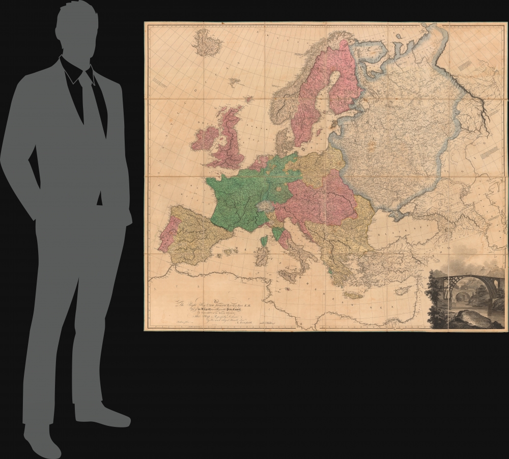
This Aaron Arrowsmith map of Europe illustrates a continent at war with Britain the only remaining power left standing against Napoleon's French Revolutionary armies. The map was published on June 1, 1798, near the end of the War of the First Coalition (1772 - 1797).
A Closer Look
Revolutionary France appears in green and stretches well into Central Europe. Austria had ceded the Austrian Netherlands (Belgium) to France in 1797 as part of the Treaty of Campo Formio. Napoleon Bonaparte (1769 - 1821) and his army captured Milan in 1796 and Manta in 1797. Austria-Hungary occupies Central Europe and is shaded pink, while Prussia is colored yellow and occupies northeastern Europe bordering Russia. Shaded yellow, the Ottoman Empire dominates southeastern Europe, including Greece.The Cartouche - 'The Iron Bridge'
The cartouche situated in the lower right features an illustration of 'The Iron Bridge', the first major cast iron bridge in the world. Spanning the River Severn in Shropshire, England, 'The Iron Bridge' opened in 1781 and still stands. Today the bridge, along with Ironbridge Gorge and the nearby settlement of Ironbridge form the UNESCO Ironbridge Gorge World Heritage Site.The War of the First Coalition (1792 - 1797/1798)
By this point, France had convinced Spain to sign an armistice, defeated Austria, conquered parts of modern-day Italy, and put down a rebellion in the Vendée (western France). Prussia had signed the 1795 Peace of Basel three years earlier. It appeared that France could not be stopped. However, the war was not a flawless string of successes. France lost several battles at the beginning of the war, and the execution of King Louis XVI united Europe against the Revolutionaries. It was not until the French instituted conscription in 1793, that they began to see success. The emergence of a brilliant young officer named Napoleon Bonaparte also helped improve France's battlefield results. Nonetheless, setbacks still occurred, including a February 1797 invasion of Wales that ended in the unconditional surrender of 1,400 French troops. Even so, by June 1798, only Britain remained in the fight against France. Napoleon, knowing that the French Navy was no match for the British fleet, elected to launch an invasion of Egypt and landed near Cairo in June 1798. This led to the War of the Second Coalition (1798 - 1802), the Battle of the Pyramids in July (a great French victory), and the Battle of the Nile in August (when Admiral Horatio Nelson decimated the French fleet). The French Revolutionary Wars lasted until 1802, when the British and the French signed the Treaty of Amiens. Less than a year later the Napoleonic Wars (1803 - 1815), finally ending after Napoleon's second (and final) exile to Saint Helena.Publication History and Census
This map was created and engraved by George Allen and published by Aaron Arrowsmith on June 1, 1798. It is dedicated to Sir Joseph Banks (1743 - 1820), an explorer, naturalist, and a patron of the sciences. A note in the upper left thanks George Ellis for his help with the cartography of eastern and southeastern Europe. We note a dozen examples cataloged in OCLC: Harvard University, the Boston Athenaeum, the University of Chicago, the University of Michigan, the University of British Columbia, the National Library of Scotland, and the Bibliothèque nationale de France, along with five others.CartographerS
Aaron Arrowsmith (1750-1823), John Arrowsmith (1790-1873), and Samuel Arrowsmith. The Arrowsmith family were noted map engravers, publishers, geographers, and cartographers active in the late 18th and early 19th century. The Arrowsmith firm was founded by Aaron Arrowsmith, who was trained in surveying and engraving under John Cary and William Faden. Arrowsmith founded the Arrowsmith firm as a side business while employed by Cary. The firm specialized in large format individual issue maps containing the most up to date and sophisticated information available. Arrowsmith's work drew the attention of the Prince of Wales who, in 1810, named him Hydrographer to the Prince of Wales, and subsequently, in 1820, Hydrographer to the King. Aaron Arrowsmith was succeeded by two sons, Aaron and Samuel, who followed him in the map publication business. The Arrowsmith firm eventually fell to John Arrowsmith (1790-1873), nephew of the elder Aaron. John was a founding member of the Royal Geographical Society. The firm is best known for their phenomenal large format mappings of North America. Mount Arrowsmith, situated east of Port Alberni on Vancouver Island, British Columbia, is named for Aaron Arrowsmith and his nephew John Arrowsmith. More by this mapmaker...
George Allen (fl. 1786 - 1814) was a British map, chart, music, and writing engraver. Allen created work for numerous publishers, including John Haywood, Laurie and Whittle, Arrowsmith, William Faden, and John Purdy. Learn More...
Condition
Very good. Dissected and mounted on linen in thirty-two (32) panels. Original color. Closed tear extending four (4) inches through printed area along right border.
References
OCLC 43160171.