
This item below is out of stock, but another example (left) is available. To view the available item, click "Details."
Details
1540 / 1556 Munster Map of Europe (1st block)
$2,750.00
1552 Munster Modern Map of Europe (1st block)
Europe-munster-1540-3$1,375.00

Title
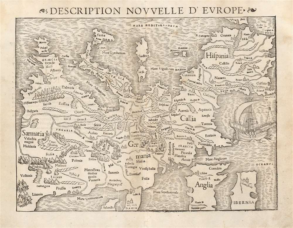
Description Nouvelle D'Europe.
1540 (undated) 10.5 x 13.5 in (26.67 x 34.29 cm)
1540 (undated) 10.5 x 13.5 in (26.67 x 34.29 cm)
Description
This is a handsome 1552 example of Sebastian Münster's southern-oriented map of Europe: an early French edition of the first acquirable map of Europe based on contemporary geographical information, and the only generally acquirable derivative of Martin Waldseemüller's unobtainable 1511 map of Europe. Münster's Geographia and Cosmographia provided for many years the literate European's only glimpses of the world, and these two works contained a number of maps with previously unseen contemporaneous knowledge of the areas they depicted. For Münster's readership, this map was almost certainly the first depiction of their home continent not based upon the 2nd century work of Claudius Ptolemy.
Cracks in the block would increase in severity until 1571 or 1572, when the badly worn woodblock was replaced with a similar (but easily distinguishable) woodcut which remained in Münst er's opus until 1578, with the exception of the Italian editions of 1571 and 1575, which appear to have been produced using maps printed for the Italian 1558 edition. All editions of 1588 and later contained new maps derived from Ortelius.
The French editions of La Cosmographie Universelle are scarce, appearing in only two examples in the Bibliotheque National de France. In its various editions, we see perhaps a dozen separate examples of the map in OCLC.
The Southern Orientation
The southern orientation of the map, which sets it apart from all other well-known 16th century maps of Europe, has caused it to languish somewhat as an ill-understood curiosity. As such, it has shared the fate of Münster's Asia, as observed by Suarez:Munster’s important map of Asia… has in our day too often been glossed over as the quaint relic of a naïve mapmaker.The 'upside-down-ness' of the map is, after all, unusual among most published maps even of the sixteenth century. But this orientation is neither an error, nor a regression, nor a touch of whimsy. It is an indication of the map’s modernity. The convention of keeping north at the 'top' of a map was inherited from Ptolemy's maps, and those which Münster produced based on Ptolemaic sources retained that second-century geographer’s northern orientation. However, regional maps printed in Germany in the first part of the 16th century for the use of travelers were oriented to the south in order to be used in conjunction with a solar compass. Since these represented Munster’s most accurate and detailed modern sources, his maps derived from them virtually all shared the same, southern, orientation. Münster's intent to produce a modern map was made explicit in the map's title in its German editions, which translated to 'Europe, a Third Part of the World: Useful to Our Era.' Although a map such as this would be of little usefulness to a traveler, it would have been extremely useful in understanding one's place in Europe, and Europe's place in the world.
Münster's Precedents
Like all geographers of the 16th century, Münster relied heavily on the framework laid down in the 2nd century by Claudius Ptolemy (83 - 161 AD). His studies were reinforced by much more state-of-the-art scholarship, however, including that of the great cosmographer Martin Waldseemüller (1470 - 1520), whose 1511 Carta Itineraria Europae, provided the basis for the production of this map. The Carta Itineraria, a four-sheet wall map of Europe (which exists in a single copy of its 1520 edition) was in turn heavily influenced by the 1500 and 1501 traveler’s maps of Erhard Etzlaub (1455 - 1532). While Waldseemuller’s grand work includes considerably more detail than Münster’s much smaller map, its influence both in terms of scope and orientation is unmistakable. The only other derivatives are Münster’s own extremely rare 1536 Tabula Europa, the precursor to the map of Europe that he included in Geographia and Cosmographia, and the scarce 548 Johann Stumpf map baseds on this one.The Only Show In Town
Between the 1511 Waldseemuller and the 1536 Münster, there appear to have been no comparable modern representations of Europe produced. A very schematic chart of Europe appears in Bordone’s 1528 Isolario, but the coastal outlines betray a heavy debt to Ptolemy, and the interiors include almost no information, in contrast to the relative wealth of modern place names in Münster.The Map's Scope and Content
Münster, like the modern geographers he most emulated, was German and the heart of his map is consequently German as well: in sharing the southern orientation of the Waldseemüller and Etzlaub maps, he is emphasizing the map's German-ness as well as its modernity. The map's reach embraces Spain and part of Ireland to the west, and extends eastwards to include the Black Sea coast and the mouth of the Danube, Bulgaria, Moldavia, and Livonia. The African shores of Gibraltar appear to the south, as does Sicily. The northern reaches fall beyond the scope of this map, which truncates Ireland and Scotland, shows only the southern portion of Denmark, and only the southernmost extent of Sweden. The body of the map is rich with the place names of the greatest cities of Münster's era: nations are named as well. Mountain ranges are shown pictorially and are reasonably accurately placed, as are Europe's major rivers. Forest regions are also indicated pictorially. The map is not without decoration - the attractively-executed woodcut includes a fine ship, sailing off the coast of France.Publication History and Census
The printing history of this map is long and convoluted. It first appears in Münster's 1540 edition of Ptolemy's Geographia, and appeared in all editions of that work with only slight variations until the final 1552 edition. Beginning in 1544, the map was among the 24 foretext maps featured in Münster's Cosmographia, in which this map appeared until about 1569. Whereas Geographia only appeared in Latin, Münster's new work was published in German, Latin, French, and Italian (the sole Czech edition of 1554 had only one map of Bohemia). The movable stereotype text with which the map was lettered exhibits slight variations from edition to edition, as does the verso text. The map's title was added in letterpress to every edition, and also exhibited many variations over the course of its print history. A full census of the states of this map has not been compiled, several typographic changes occurring on the map most closely corresponds to examples we have examined dating to 1553, and which do not appear after that date; thus we are classifying this example as belonging to the 1552 French language La Cosmographie Universel.Cracks in the block would increase in severity until 1571 or 1572, when the badly worn woodblock was replaced with a similar (but easily distinguishable) woodcut which remained in Münst er's opus until 1578, with the exception of the Italian editions of 1571 and 1575, which appear to have been produced using maps printed for the Italian 1558 edition. All editions of 1588 and later contained new maps derived from Ortelius.
The French editions of La Cosmographie Universelle are scarce, appearing in only two examples in the Bibliotheque National de France. In its various editions, we see perhaps a dozen separate examples of the map in OCLC.
CartographerS
Sebastian Münster (January 20, 1488 - May 26, 1552), was a German cartographer, cosmographer, Hebrew scholar and humanist. He was born at Ingelheim near Mainz, the son of Andreas Munster. He completed his studies at the Eberhard-Karls-Universität Tübingen in 1518, after which he was appointed to the University of Basel in 1527. As Professor of Hebrew, he edited the Hebrew Bible, accompanied by a Latin translation. In 1540 he published a Latin edition of Ptolemy's Geographia, which presented the ancient cartographer's 2nd century geographical data supplemented systematically with maps of the modern world. This was followed by what can be considered his principal work, the Cosmographia. First issued in 1544, this was the earliest German description of the modern world. It would become the go-to book for any literate layperson who wished to know about anywhere that was further than a day's journey from home. In preparation for his work on Cosmographia, Münster reached out to humanists around Europe and especially within the Holy Roman Empire, enlisting colleagues to provide him with up-to-date maps and views of their countries and cities, with the result that the book contains a disproportionate number of maps providing the first modern depictions of the areas they depict. Münster, as a religious man, was not producing a travel guide. Just as his work in ancient languages was intended to provide his students with as direct a connection as possible to scriptural revelation, his object in producing Cosmographia was to provide the reader with a description of all of creation: a further means of gaining revelation. The book, unsurprisingly, proved popular and was reissued in numerous editions and languages including Latin, French, Italian, and Czech. The last German edition was published in 1628, long after Münster's death of the plague in 1552. Cosmographia was one of the most successful and popular books of the 16th century, passing through 24 editions between 1544 and 1628. This success was due in part to its fascinating woodcuts (some by Hans Holbein the Younger, Urs Graf, Hans Rudolph Manuel Deutsch, and David Kandel). Münster's work was highly influential in reviving classical geography in 16th century Europe, and providing the intellectual foundations for the production of later compilations of cartographic work, such as Ortelius' Theatrum Orbis Terrarum Münster's output includes a small format 1536 map of Europe; the 1532 Grynaeus map of the world is also attributed to him. His non-geographical output includes Dictionarium trilingue in Latin, Greek, and Hebrew, and his 1537 Hebrew Gospel of Matthew. Most of Munster's work was published by his stepson, Heinrich Petri (Henricus Petrus), and his son Sebastian Henric Petri. More by this mapmaker...
Martin Waldseemüller (September 11, 1470 - March 16, 1520) was a German cartographer, astronomer, and mathematician credited with creating, along with Matthias Ringmann, the first map to use the placename America. He was born in Wolfenweiler, near Freiburg im Breisgau. Waldseemüller studied at the University of Freiburg and, on April 25, 1507, became a member of the Gymnasium Vosagese at Saint-Dié. Martin Waldseemüller was a major proponent of theoretical or additive cartography. Unlike contemporary Portuguese and Spanish cartographers, who left maps blank where knowledge was lacking, Waldseemüller and his peers speculated based upon geographical theories to fill unknown parts of the map. He is best known for his Universalis Cosmographia a massive 12-part wall map of the world considered the first map to contain the name America, today dubbed as 'America's Birth Certificate'. This map also had significance on other levels, as it combined two previously unassociated geographical styles: Ptolemaic Cartography, based on an ancient Greek model, and the emergent 'carta marina', a type of map commonly used by European mariners in the late 15th and 16th centuries. It also extended the traditional Ptolemaic model westward to include the newly discovered continent of America, which Waldseemüller named after the person he considered most influential in its discovery, Amerigo Vespucci. When Waldseemüller died in 1520, he was a canon of the collegiate Church of Saint-Dié. In contemporary references his name is often Latinized as Martinus Ilacomylus, Ilacomilus, or Hylacomylus. Learn More...
Heinrich Petri (1508 - 1579) and his son Sebastian Henric Petri (1545 – 1627) were printers based in Basel, Switzerland. Heinrich was the son of the printer Adam Petri and Anna Selber. After Adam died in 1527, Anna married the humanist and geographer Sebastian Münster - one of Adam's collaborators. Sebastian contracted his stepson, Henricus Petri (Petrus), to print editions of his wildly popular Cosmographia. Later Petri, brought his son, Sebastian Henric Petri, into the family business. Their firm was known as the Officina Henricpetrina. In addition to the Cosmographia, they also published a number of other seminal works including the 1566 second edition of Nicolaus Copernicus's De Revolutionibus Orbium Coelestium and Georg Joachim Rheticus's Narratio. Learn More...
Source
Münster, Sebastian, La Cosmographie Universelle, (Basel: Petri) 1552.
The Cosmographia Universalis, one of the greatest geographical and historical works of the 16th century, 'taught nearly three generations of laymen most of what they knew about the world beyond their native places' (Strauss). Filled with maps, views, and rich descriptions of places throughout Europe and beyond, it was the best general source of geographical information until the advent of Ortelius' Theatrum. It was first issued by Sebastian Munster (1488 - 1552) in its 1544 German edition, and stayed in print long after its author's death in thirty five editions, and in five languages. (Of these, the 1550 and 1552 editions are widely regarded as the most complete and truest to the author's intentions: thereafter, later editors continued to add to the work's text; editions from 1588 onwards employed an entirely different set of maps produced on Ortelius' model.) Munster's goal, initially, was to rally his homeland's humanists and scholars to produce a new map of Germany in order to 'see what kind of a land our ancestors conquered for their home... bring honor to our country and place its beauties in the clear light of day.' Munster's project quickly expanded to cover the known world in its scope to produce a 'sufficiently large volume, in which I touch upon the foundation of all nations and kingdoms, their peculiarities, rivers, mountains, customs of men, royal successions, origins of the more important cities, succinct histories, religions, characteristics and fertility of lands... in Germany, however, I tarry a little longer'.
Munster's methodology in Cosmographia is notable in particular for his dedication to providing his readers with direct access to firsthand reports of his subjects wherever possible. Many of the maps were the result of his own surveys; others, the fruit of an indefatigable letter writing campaign to scholars, churchmen and princes throughout Europe, amicably badgering them for maps, views, and detailed descriptions of their lands. For lands further afield than his letters could reach, Munster relied on the best that the authorities of northern European scholarship could offer: he was well familiar with the work of Waldseemuller and other geographers of the early 16th century, and was well connected with the best geographers of his own generation. A disproportionate number of the maps of Cosmographia show contemporary geographical knowledge of the their respective areas for the very first time: The first map to show the continents of the Western Hemisphere; the first map to focus on the continent of Asia; the first modern map to name the Pacific Ocean; the first map to use a key; the first modern map of the British Isles and so on. Even in cases where earlier maps exist, Munster's works very often remain the earliest such acquirable by the collector.
Munster's methodology in Cosmographia is notable in particular for his dedication to providing his readers with direct access to firsthand reports of his subjects wherever possible. Many of the maps were the result of his own surveys; others, the fruit of an indefatigable letter writing campaign to scholars, churchmen and princes throughout Europe, amicably badgering them for maps, views, and detailed descriptions of their lands. For lands further afield than his letters could reach, Munster relied on the best that the authorities of northern European scholarship could offer: he was well familiar with the work of Waldseemuller and other geographers of the early 16th century, and was well connected with the best geographers of his own generation. A disproportionate number of the maps of Cosmographia show contemporary geographical knowledge of the their respective areas for the very first time: The first map to show the continents of the Western Hemisphere; the first map to focus on the continent of Asia; the first modern map to name the Pacific Ocean; the first map to use a key; the first modern map of the British Isles and so on. Even in cases where earlier maps exist, Munster's works very often remain the earliest such acquirable by the collector.
Condition
Very good. Faint scuffing at lower centerfold, nearly invisible. Else excellent.
References
OCLC 794717379. Rumsey 11623.065 (1540). Karrow, R., Mapmakers of the Sixteenth Century and Their Maps, 58. Suarez, T., Early Mapping of Southeast Asia, p. 129. Meurer, P., Cartography in the German Lands 1450-1650, pp 1172-1245. Woodward, D. The History of Cartography, Volume 3. Bagrow, L., 'Carta Itineraria Europae Martini Ilacomili, 1511', Imago Mundi, vol. XI, pp. 149-150.