1815 Thomson Map of Europe
Europe-thomson-1815$250.00

Title
Europe.
1815 (undated) 18.25 x 21.25 in (46.355 x 53.975 cm) 1 : 12000000
1815 (undated) 18.25 x 21.25 in (46.355 x 53.975 cm) 1 : 12000000
Description
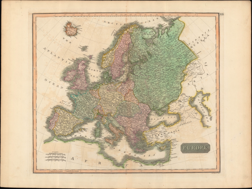
A lovely example of John Thomson's c. 1815 map of Europe, engraved by John Menzies, for the first edition of Thomson's New General Atlas, published in 1817. Despite the publication date, the map was prepared before the post-Napoleonic order had solidified and reflects a high degree of uncertainty over the borders of Europe emerging from the Congress of Vienna.
The whole is beautifully engraved in the minimalist English style pioneered in the early part of the 19th century. Thomson maps are known for their stunning color, awe inspiring size, and magnificent detail. Thomson's work, including this map, represents some of the finest cartographic art of the 19th century.
A Closer Look
This fascinating hand colored map depicts Europe in the immediate aftermath of Napoleon's defeat at Waterloo. On the one hand, German lands are unified along the lines of the German Confederation, a key component of the settlement at the end of the Napoleonic Wars. On the other, the Netherlands remain divided, as does Poland, though it is not yet fully partitioned (the colorist appears to have been confused too, as part of Hungary is shaded the same orange as Galicia). Red lines trace out the eventual boundaries of Prussia, Lombardy-Venetia, and Russia at the end of the Congress of Vienna. These details suggest that the map was prepared in 1815 as the Congress of Vienna was concluding or soon after its completion.The whole is beautifully engraved in the minimalist English style pioneered in the early part of the 19th century. Thomson maps are known for their stunning color, awe inspiring size, and magnificent detail. Thomson's work, including this map, represents some of the finest cartographic art of the 19th century.
Publication History and Census
This map was exquisitely engraved by John and George Menzies and issued as Plate No. 8 in Edinburgh cartographer John Thomson's 1817 New General Atlas. It differs slightly from the examples held by the David Rumsey Historical Map Collection and previously sold by us, which were prepared somewhat earlier, before the Battle of Waterloo (showing the southern part of the Netherlands as part of France, for example). The plate was not modified, but the colorists, presumably at Thomson's instruction, shaded territories to reflect the changed borders determined in the intervening months.CartographerS
John Thomson (1777 - c. 1841) was a Scottish cartographer, publisher, and bookbinder active in Edinburgh during the early part of the 19th century. Thomson apprenticed under Edinburgh bookbinder Robert Alison. After his apprenticeship, he briefly went into business with Abraham Thomson. Later, the two parted ways, John Thomson segueing into maps and Abraham Thomson taking over the bookbinding portion of the business. Thomson is generally one of the leading publishers in the Edinburgh school of cartography, which flourished from roughly 1800 to 1830. Thomson and his contemporaries (Pinkerton and Cary) redefined European cartography by abandoning typical 18th-century decorative elements such as elaborate title cartouches and fantastic beasts in favor of detail and accuracy. Thomson's principle works include Thomson's New General Atlas, published from 1814 to 1821, the New Classical and Historical Atlas of 1829, and his 1830 Atlas of Scotland. The Atlas of Scotland, a work of groundbreaking detail and dedication, would eventually bankrupt the Thomson firm in 1830, at which time their plates were sequestered by the court. The firm partially recovered in the subsequent year, allowing Thomson to reclaim his printing plates in 1831, but filed again for bankruptcy in 1835, at which time most of his printing plates were sold to A. K. Johnston and Company. There is some suggestion that he continued to work as a bookbinder until 1841. Today, Thomson maps are becoming increasingly rare as they are highly admired for their impressive size, vivid hand coloration, and superb detail. More by this mapmaker...
John Menzies (October 27, 1772 - October 16, 1857) was a Scottish engraver active in Edinburgh during the late 18th and early 19th centuries. Menzies mastered engraving as an apprentice to James Rymer. In 1811, he partnered with his younger brother, George Menzies, to found the engraving firm of J. and G. Menzies, which was active until about 1831. Later his son, also named John, joined the firm and they engraved jointly under the imprint of J. Menzies and Son. At its height, the Menzies firm employed three men and three apprentices. Menzies engraved maps for Thomas Brown and John Thomson, among others. After his death, his son, John Menzies II (1819 – 1891), continued the family business until about 1891. Learn More...
Source
Thomson, J., A New General Atlas, (Edinburgh: Baldwin, Cradock, Joy) 1817.
Thomson's New General Atlas was first published in 1817 and continued to be published until about 1821. This is the first of Thomson's major cartographic works and the atlas for which is most celebrated. The New General Atlas follows in the Edinburgh School, which eschews excessive decoration in favor of a more minimalistic fact-based cartographic vision, as established by John Pinkerton, Laurie and Whittle, John Cary, and others in the previous decades. The maps are notable for their massive scale, heavy stock, elegant color work, and easy-to-read typefaces. Although the atlas stopped being published after 1821, Thomson continued to offer 'supplementary' maps that could be tipped into the atlas as late as 1830, when he declared bankruptcy. The maps in the Thomson Atlas were engraved by Thomas Clerk, William Dassauville, Nathaniel Rogers Hewitt, James Kirkwood, Robert Kirkwood, John Menzies, George Menzies, Edward Mitchell, John Moffatt, Samuel John Neele, Robert Scott, and James Wyld.
Condition
Good. Light offsetting. Closed margin tears professionally repaired on verso.
References
Rumsey 1007.009. Phillips (Atlases) 731. Newberry Library: Ayer 135 T4 1817.