This item has been sold, but you can get on the Waitlist to be notified if another example becomes available, or purchase a digital scan.
1943 Minneapolis Morning Tribune Map of Europe Before the Allied Invasion
EuropeAlliedBlow-anon-1943$150.00

Title
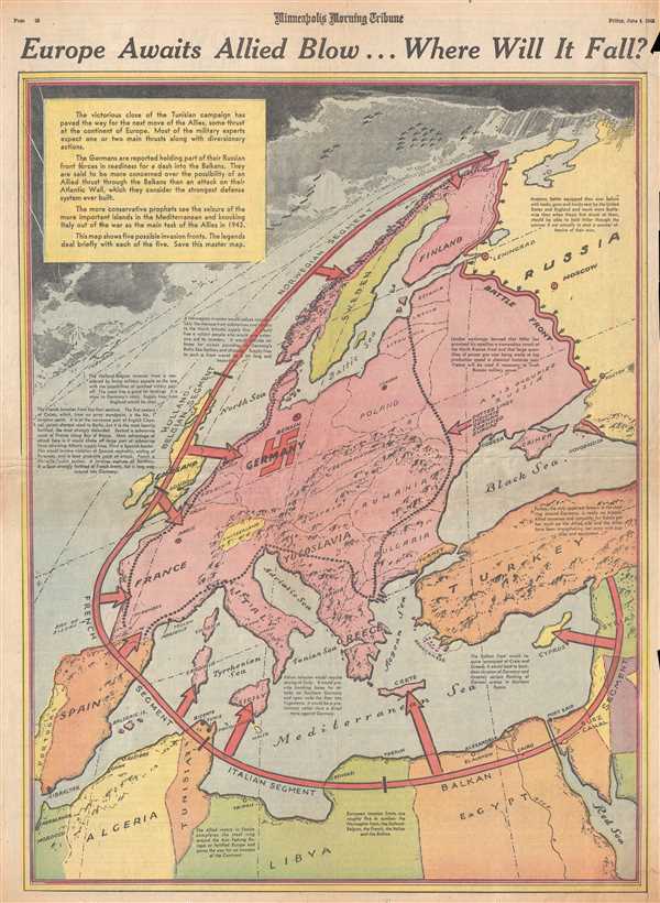
Europe Awaits Allied Blow…Where Will It Fall?
1943 (dated) 22 x 15.5 in (55.88 x 39.37 cm) 1 : 8530000
1943 (dated) 22 x 15.5 in (55.88 x 39.37 cm) 1 : 8530000
Description
This is a Friday, June 4, 1943 Minneapolis Morning Tribune map of Europe preparing for the presumed upcoming Allied invasion. The map depicts the continent from the Atlantic Ocean to the Eastern Front between the Russians and the Germans (which was not far from Moscow and Leningrad) and from the Arctic Ocean to North Africa. Known as 'Fortress Europe', Nazi Germany had fortified the continent since their Spring 1940 offensive had conquered all of Western Europe and thrown the British off the continent. Since June 1941, the only front on the continent had been the fought between the Russians and the Germans in Eastern Europe, and Stalin was eager for a second front to be opened in the western part of the continent. Here, the relative unknown of where the Allies would land an invasion force is graphically illustrated in such a way that the immense amount of possibilities for the invasion become evident. Hitler feared the coming invasion, believing it to be a certainty, and fortified as much of the continent as possible.
Stylistically this map owes a debt to the work of Richard Edes Harrison, an American illustrator and cartographer who, working for Fortune magazine, pioneered a new style of representing the world for WWII era propaganda maps. Edes developed the convention of using spherical perspective with an exaggerated vertical dimension, as on the present map, to illustrate part of the world as part of a greater global situation. This map was printed by the Minneapolis Morning Tribune on Friday, June 4, 1943.
Stylistically this map owes a debt to the work of Richard Edes Harrison, an American illustrator and cartographer who, working for Fortune magazine, pioneered a new style of representing the world for WWII era propaganda maps. Edes developed the convention of using spherical perspective with an exaggerated vertical dimension, as on the present map, to illustrate part of the world as part of a greater global situation. This map was printed by the Minneapolis Morning Tribune on Friday, June 4, 1943.
Cartographer
The Minneapolis Tribune (1867 - present) was founded by Colonel William S. King, William D. Washburn, and Dorilus Morrison and the first issue was published on May 25, 1867. In 1941, the Cowles family of Des Moines, Iowa bought the Tribune and merged it with their other holdings in Minneapolis, giving the Cowles family ownership of all the city's major newspapers. The Tribune became the city's morning newspaper, and the Star-Journal was the evening newspaper. The two published a joint Sunday edition. The newspaper is still published today, under the name Star Tribune. More by this mapmaker...
Condition
Very good. Newsprint. Closed tear extending 1.5 inches into printed area in upper right corner. Text on verso.