
This item below is out of stock, but another example (left) is available. To view the available item, click "Details."
Details
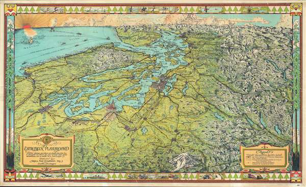
1945 Kroll Map Company Pictorial Map of Puget Sound, Washington, and Vancouver
1945 (undated) $700.00
1945 Kroll Map Company Pictorial Map of Puget Sound, Washington, and Vancouver
EvergreenPlayground-kroll-1945$225.00

Title
The Evergreen Playground. Neither Europe nor Asia nor South America has a prospect in which sea and woods and snow mountains are so united in a landscape.
1945 (undated) 19.25 x 32 in (48.895 x 81.28 cm)
1945 (undated) 19.25 x 32 in (48.895 x 81.28 cm)
Description
This is a 1945 Kroll Map Company pictorial map of Puget Sound and the surrounding region, including Seattle, Tacoma, and Olympia, Washington, and Vancouver, British Columbia. Oriented to the west-northwest, the map depicts from the Pacific Ocean to the mountains east of Seattle and from the Canadian Rockies north of Vancouver to Mount Rainier. A visually striking piece from a birds-eye view perspective, the 'Evergreen Playground' of the Pacific Northwest extends in all directions. Individual buildings in Seattle, Tacoma, Olympia, and Vancouver are illustrated, including the state capitol building in Olympia. The Seattle-Tacoma airport is also labeled. Numerous smaller towns and villages throughout the area are labeled. Both Olympic National Park and Mount Rainier National Park are depicted in detail, with several locations labeled within the park, such as Paradise Inn on the slopes of Mount Rainier. Other buildings in secluded areas are illustrated and labeled as well, the Big Four Inn, the Mt. Baker Lodge, and the Harrison Hot Springs to name a few.
The highway network is easily discernable, with each route labeled by number and by nickname, such as the National Park Highway, the Pacific Highway, and the Olympic Highway. Railroads are also illustrated and labeled, including the Northern Pacific Railroad and the Great Northern Railroad. Vancouver Island is labeled, along with the Strait of Juan de Fuca and myriad bays, points, and other coastal locations. Several ships are illustrated in the Strait of Juan de Fuca or out in the Pacific shipping lanes, either on their way to Puget Sound or out again, on the 'Great Circle Route to the Orient', or the route to Hawaii and Australia, or possibly South America. A compass, indicating that the map is oriented to the west-northwest, is situated in the upper right, with a mermaid at the center holding a trident which functions as the compass's needle.
The map's border adds to its charm. Along the sides are what appear to be Lodgepole Pines, trees native to the Pacific Northwest. In the corners, figures resembling those created by Native Americans and First Peoples native to this part of the world add to the overall aesthetic created by the map. The border enhances the feeling that this map accurately depicts the region. Several vignettes are included along the top and bottom, with outdoor activities, such as skiing, sailing, tennis, horseback riding, fishing, and hunting along the top. At the bottom, modern technological advances are depicted, such as the newest locomotive, trucks for long-haul transportation, factories, and a B-29 Superfortress. Boeing, which was based in Seattle, developed the B-29 and built it in Seattle, as well as in several other locations across the country. By 1945, the B-29 had become a recognizable aircraft, both due to its size and the large role it played in the Pacific during World War II. Two different B-29s were used to drop the atomic bombs on Hiroshima and Nagasaki in August 1945.
The inclusion of a B-29 allows us to date this map with some accuracy. The B-29 concept was not developed until 1940, with its first flight in 1942, and it was not put into service until May 1944. This allows us to date this map with some certainty to 1945. This map was created by the Kroll Map Company of Seattle in 1945.
CartographerS
Kroll Map Company (1911 - Present) is a Seattle-based map company. Founded in 1911 when Carl Kroll acquired both Anderson Map Company and Washington Map and Blueprint Company, both of which had been in business since the 1870s. From its inception, Kroll Map Company has ‘focused on mapping for real estate and local government, custom mapping, and the publication of numerous general mapping products.’ Carl Kroll sold a half-share of the company to John Loacker, his close friend and employee, in 1920. Loacker then purchased the company outright in 1925. He maintained the feel of a family business by working with his son Waldemar, who eventually took over. Waldemar J. Loacker (April 16, 1902 - February 12, 1995) worked at Kroll for the rest of his life, only leaving the company after suffering a stroke in 1992. Then his son John Loacker (b. 1955), who began working at Kroll in his youth, officially inherited the business and continues operating it to this day. In 1999, Kroll Map Company and Metsker Maps of Seattle formed a partnership of ‘two historic Seattle businesses.’ Today, the Kroll Map Company creates custom maps for individuals worldwide. More by this mapmaker...
Edwin Christian Poland (December 14, 1903 - October 13, 1991) was an American draftsman and artist. Born in Chehalis, Washington, and the son of Marth and Hans Poland, he lived in Seattle, Washington and worked for the Kroll Map Company beginning as early as 1930. Poland married Geneva Brown on August 22, 1943. Learn More...
Condition
Very good. Closed tear extending 2.5 inches into printed area professionally repaired on verso. Wear along left margin. Backed on archival tissue for stability. Blank on verso.
References
Hornsby, Stephen J., Picturing America: The Golden Age of Pictorial Maps, p. 175. Rumsey 8854.000. OCLC 34457082.