
1581 / 1608 Bünting Woodcut Map of the Peregrination of Israel

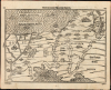
Reisen der Kinder Israel aus Egypten.
Exodus as Cartographic Pilgrimage.
- Digital Map Information
- Suitable for large format printing
- Full resolution TIFF file
- ICC color profile embedded
- Delivered instantly via download link
Exodus as Cartographic Pilgrimage.
This is Heinrich Bünting's remarkable 1581 map of the Exodus, a defining image of his revolutionary approach to Biblical geography. Bünting conceived Scripture as a kind of cartographic pilgrimage, allowing readers to follow the journeys of Biblical figures across an imagined geographical landscape. Here the Israelites' 40-year journey becomes a continuous visual narrative, beginning in Egypt, crossing the Red Sea, wandering through the deserts of Sinai and Arabia, and finally approaching the Promised Land.A Closer Look
Egypt occupies the lower left, with the Nile dividing into its great delta before reaching the Mediterranean. From there, the Israelites' route proceeds eastward across the Red Sea and then winds through the wilderness toward Canaan. The numbered stations correspond to successive stages of the Exodus, converting the Biblical account into a continuous geographical itinerary. Mountains, deserts, rivers, cities, and kingdoms provide a spatial framework for the journey, while miniature town views give settlements an appealing pictorial character.Bünting animates the geography with scenes from the Biblical narrative. Near the Red Sea, Moses stands safely on the opposite shore while Pharaoh's pursuing army, horses, and chariots are overwhelmed by the returning waters. Farther east, armed figures represent another episode in Israel's advance toward the Promised Land, while the kingdoms and peoples encountered along the route - including Edom, Moab, and Midian - are prominently identified.
The Mediterranean is particularly playful. A figure swims offshore, traditionally interpreted as a merman, although Eran Laor suggested that it represents Jonah riding the whale. Two enormous fish and an incongruously placid duck complete the maritime decoration, adding the characteristic mixture of scholarship, Biblical imagination, and visual whimsy found throughout Bünting's maps.
Bünting's Biblical Geography
Heinrich Bünting's Itinerarium Sacrae Scripturae was conceived around an innovative idea: understanding scripture through the journeys of the people who inhabited it. Rather than producing a conventional geographical atlas, Bünting organized Biblical history around movement - the travels of patriarchs, prophets, apostles, and peoples across the sacred landscape. The Exodus was particularly suited to this approach, since the Israelites' wanderings provided a ready-made itinerary linking some of the most dramatic episodes of the Old Testament.The result is consequently not intended as a geographically precise reconstruction of the Sinai Peninsula. Instead, Bünting creates a visual aid to Biblical reading, arranging places, routes, and events so that the viewer can follow the scriptural narrative geographically. This fusion of map and story helped make the Itinerarium enormously successful and one of the most distinctive works of 16th-century Biblical cartography.
Publication History and Census
This woodcut first appeared in the 1581 Helmstedt edition of Heinrich Bünting's Itinerarium Sacrae Scripturae, an influential work devoted to describing and mapping journeys recorded in the Bible. Its popularity led to numerous editions and translations, and the work remained in circulation well into the following century. The identity of the formschneider, or woodblock cutter responsible for the map, remains unknown.The present example conforms typographically to the 1608 edition of the Itinerarium. Bünting's book is well represented in institutional collections in its various editions, although separately cataloged examples of this map are considerably less common. We note nine examples cataloged separately in OCLC, and the map appears occasionally on the private market.
Cartographer
Heinrich Bünting (1545 – 1606) was a Protestant pastor and theologian. He was born in Hanover, and studied theology at the University of Wittenberg. He earned his Master's degree in 1569. He remained in Wittenberg as a pastor there, before being appointed to that same position at Alt Calenberg, in the service of the Dukes of Saxony. The estate was dissolved when the marriage of the Duchess Sidona and Duke Eric the Younger foundered, and Bünting became pastor in Gronau in 1575. In Gronau, he wrote his two major works - the 1581 Itinerarium Sacrae Scripturae, and the 1584 Brunswick and Lüneburg Chronicle. He produced a smaller work on Biblical coins and measures in 1582. He would briefly serve as superintendent in Goslar, but he would be dismissed as a result of theological differences. Stung, he returned to his hometown and changed to the less controversial profession of a beer brewer, until his death in 1606. The work for which he is best known, Itinerarium Sacrae Scripturae, was the first complete summary of biblical geography. It remained in print in more than sixty editions, long after his death. Earlier editions contain some of the most distinctive and sought after maps, most notably his map of the world in the shape of a cloverleaf, and an allegorical map of Asia in the form of a Pegasus. Further Details...
Source
Bünting, Heinrich, Itinerarium Sacrae Scripturae, (Magdeburg: Kirchner) 1608.
Condition
Very good. Marginal mends not impacting printed image, else an excellent untrimmed example.
References
OCLC 163817121. Laor, E. Mapping of the Holy Land 142.