This item has been sold, but you can get on the Waitlist to be notified if another example becomes available, or purchase a digital scan.
1921 Bain City Map or Plan of San Francisco
EZGuideSanFran-bain-1921$175.00

Title
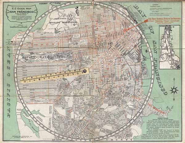
E-Z Guide Map of San Francisco California (with Patent Indicator) Showing at a Glance the Exact Location of Banks, Apartment Houses, Depots, Railway Offices, Theatres, Stores and Street Locations.
1921 (dated) 13 x 17 in (33.02 x 43.18 cm) 1 : 32000
1921 (dated) 13 x 17 in (33.02 x 43.18 cm) 1 : 32000
Description
This is a 1921 Fred B. Bain city map or plan of San Francisco, California. The map depicts the city of San Francisco from the Pacific Ocean and Laguna de la Merced to San Francisco Bay and from the Presidio Military Reservation and the Presidio Golf Club to San Mateo County. All the streets are labeled, along with myriad buildings, parks, and other points of interest. Golden Gate Park holds a dominant position and is depicted in detail, with several different animal enclosures, buildings, and other attractions identified. By employing the innovative design, one can easily find any location on the map with the help of the indicator. Hundreds of locations are indexed alphabetically on the verso, allowing for quick reference. A legend is located in the upper right corner and notes that street railway lines and railway lines are depicted in the city map and that roads and railway lines are illustrated in the inset map of the district, located along the upper right border. It depicts the region from San Francisco to San Jose. Numerous cities are labeled, including Palo Alto, Menlo Park, and San Mateo.
This map was published and copyrighted by Fred B. Bain, Inc. of San Francisco
This map was published and copyrighted by Fred B. Bain, Inc. of San Francisco
Cartographer
Fred Barned Bain (14 March 14, 1880 - November 17 1968) was an American advertiser and businessman based in San Francisco. He was born in New York City, the son of a grocer; the family moved to Alameda shortly thereafter, appearing there in voting records in 1890. By 1910 he had a young family of his own in Oakland, and was working as a sales agent for a manufacturing firm. He did not stay an employee for long: by 1915 he had struck out on his own with an advertising business. Alhough want ads for his company called for salesmen to handle 'a high-class line of advertising calendars and novelties,' surviving products from his company appear to be predominantly maps. In particular, his series of 'E-Z guide' maps seem to have been successful. Bain produced maps mostly of regional California, and city plans. OCLC shows maps of Oakland, San Francisco, Los Angeles and San Diego; Portland, Oregon; and Seattle, Washington. His customers, overwhelmingly, were banks who used Bain's maps as promotional tools. More by this mapmaker...
Condition
Very good. Wear along original fold lines. Index of locations for use in conjunction with map on verso. Advertisements for The First National Bank of San Francisco on verso.
References
OCLC 23947315.