This item has been sold, but you can get on the Waitlist to be notified if another example becomes available, or purchase a digital scan.
1874 Sanford and Leggett City Plan or Map of Farmington, Maine
FarmingtonMaine-sanfordleggett-1874$750.00


Title
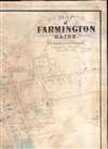
Map of Farmington Maine.
1874 (dated) 44 x 32.25 in (111.76 x 81.915 cm) 1 : 2700
1874 (dated) 44 x 32.25 in (111.76 x 81.915 cm) 1 : 2700
Description
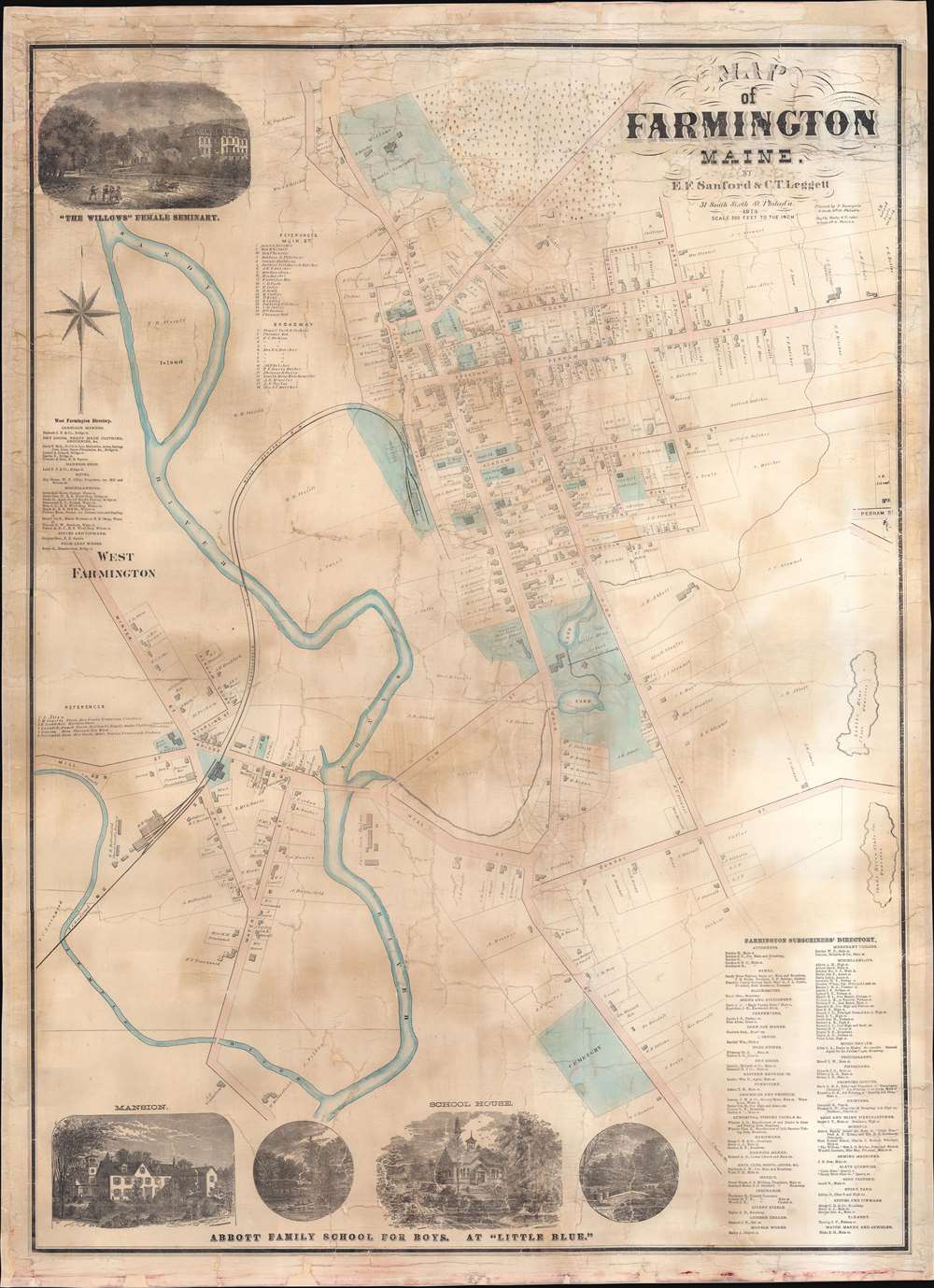
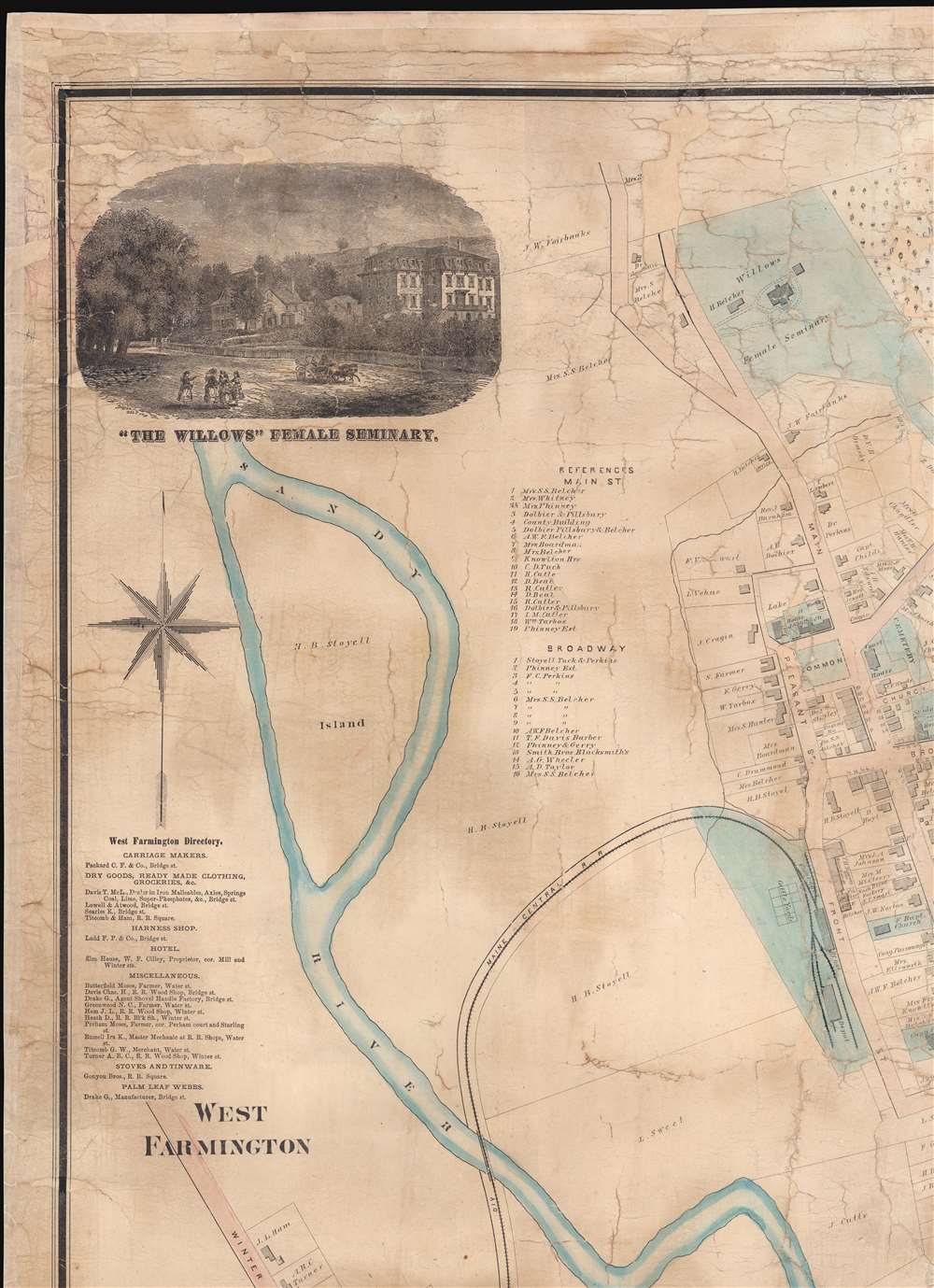
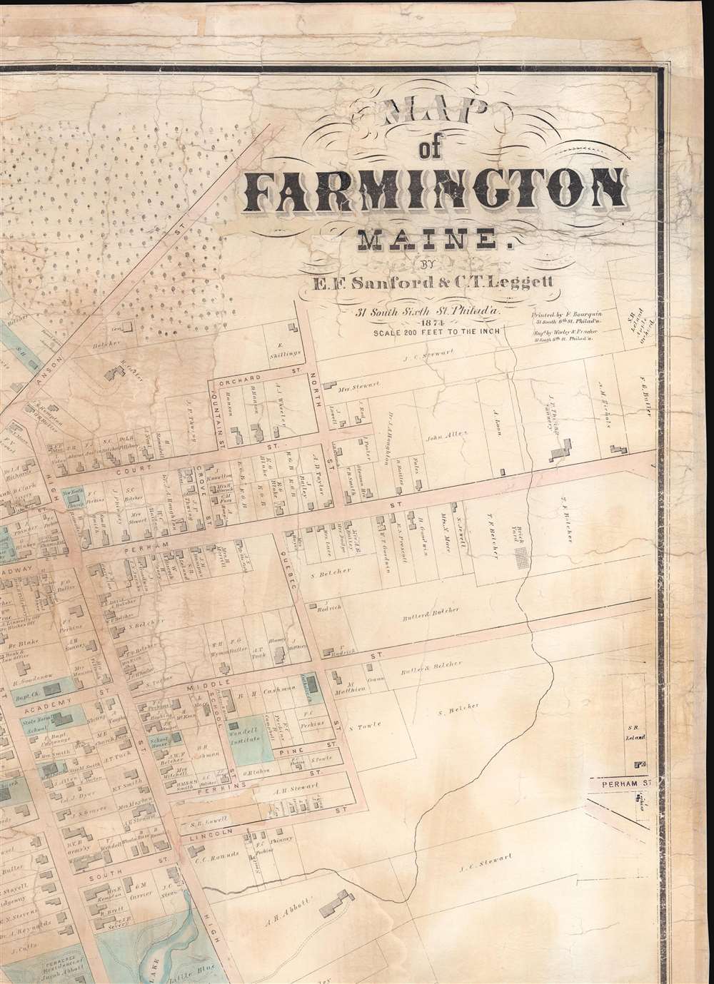
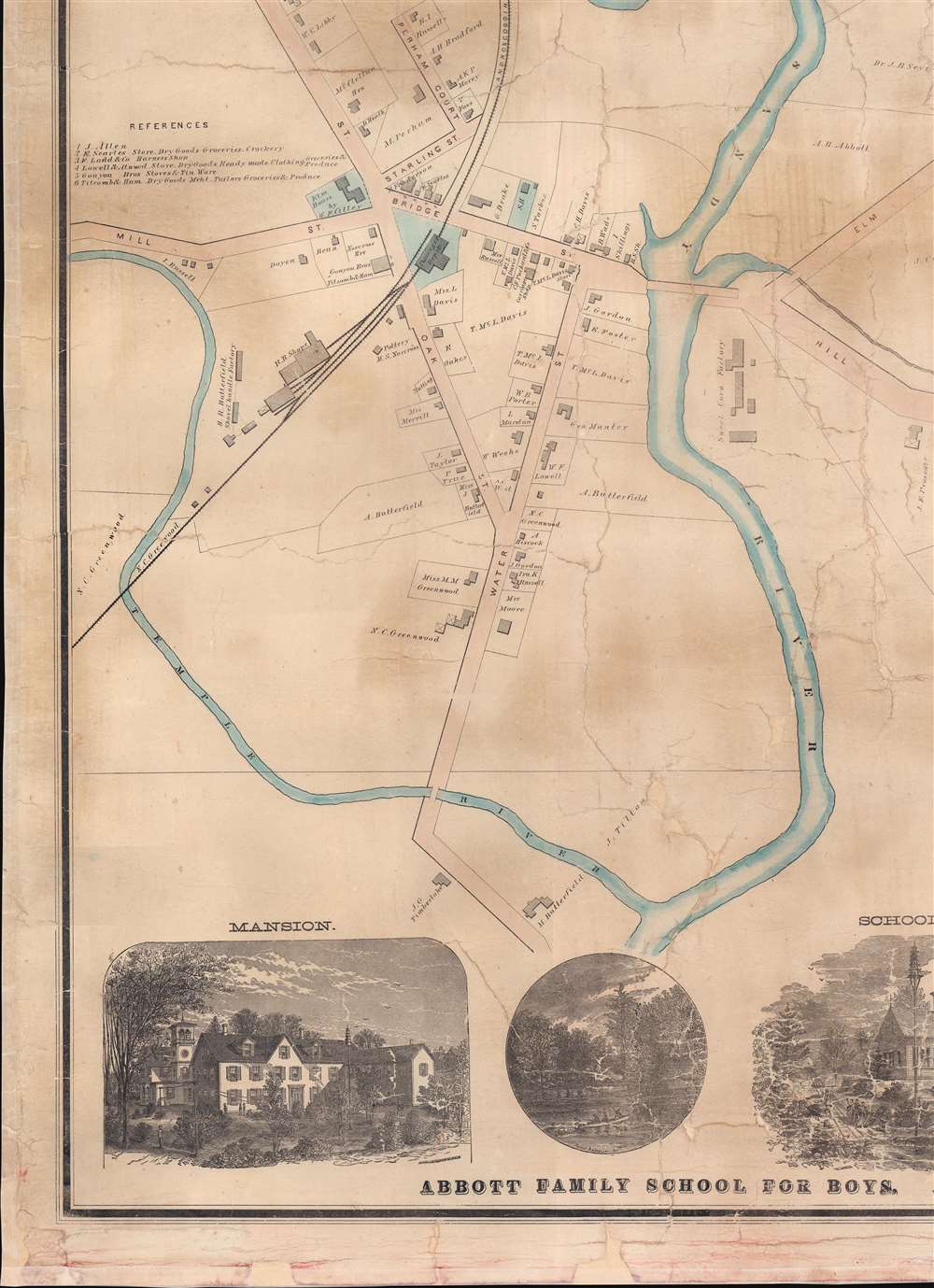
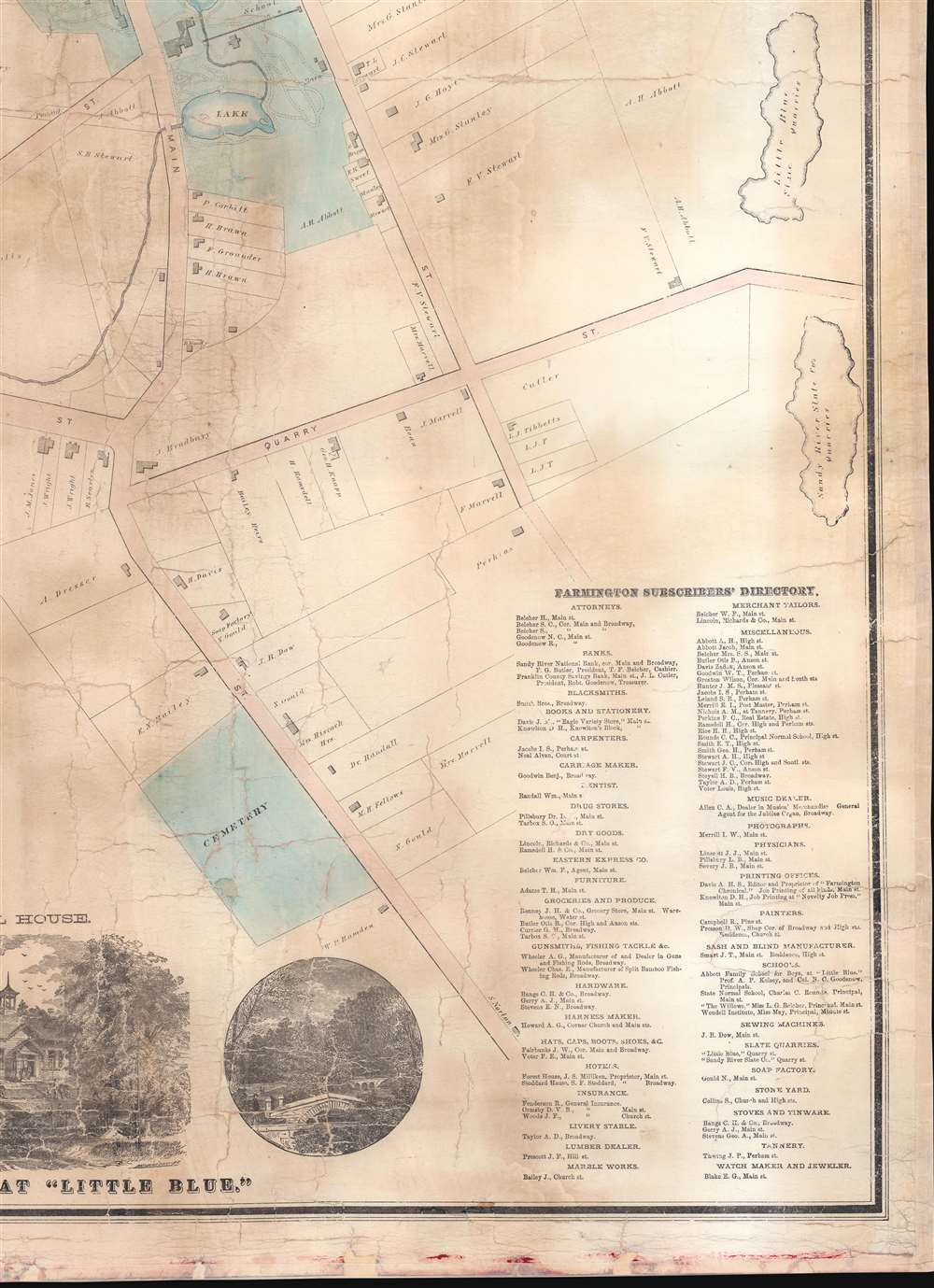
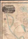
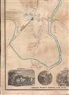
This is an 1874 E.F. Sanford and C.T. Leggett city plan or map of Farmington, Maine. Created by soliciting subscriptions from the town's businesspeople and residents, the map depicts from the Willows Female Seminary to S. Norton's house south of the cemetery on Main Street and from the railroad shops in West Farmington to the slate quarries east of town. Houses throughout town are illustrated and identified by the owner's name and the lots are delineated. Schools (including the State Normal School), churches, and offices are labeled throughout town as well. Other illustrated locations around town include the railroad depot (serviced by the Androscoggin Division of the Maine Central Railroad), the sweet corn factory, the brick yard, the cattle yards, S.R. Leland's Apple Orchard, and the H.R. Butterfield shovel handle factory. References for thirty-five numerically identified locations along Main Street and Broadway in Farmington occupy a space in the upper left quadrant. A directory for West Farmington appears along the left border. A view of the Willows Female Seminary occupies the upper left corner. A series of four views along the bottom border highlight different scenes associated with the Abbott Family School for Boys.
Publication History and Census
This map was created and published by E.F. Sanford and C.T. Leggett, engraved by George Worley and William Bracher, and printed by Frederick Bourquin in 1874. We note a single cataloged example, which is part of the collection of the Osher Map Library at the University of Southern Maine.CartographerS
E.F. Sanford (fl. c. 1868 - c. 1875) was a map and atlas publisher active in Philadelphia during the mid-19th century. Sanford was part of the partnership Sanford, Everts, and Company, for a time. He also published maps with C.T. Leggett. Some of Sanford's maps were wall maps of New England towns. More by this mapmaker...
C.T. Leggett (fl. c. 1870 - 1895) was a surveyor and cartographer active during the mid to late 19th century. Leggett published maps with E.F. Sanford. He did surveying and canvassing work for several different map, view, and atlas publishers during his career throughout the United States. He worked in Kansas, Maine, Missouri, Vermont, and Wisconsin compiling work for maps and atlases. Learn More...
George Worley (c. 1819 - November 21, 1879) was an English lithographer active in Philadelphia. Born in England, Worley lived in Philadelphia by 1843 where he worked as an artist. He worked as a lithographer for Robert Pearsall Smith in his map publishing establishment from c. 1856 - 1859. In 1858 or 1859, Worley became a partner in the firm Worley, Bracher, and Matthias with William Bracher (1827 - 1912) and Benjamin Matthias. Worley, Bratcher, and Matthias lasted until 1860 when Matthais left. After Matthias's departure, Worley and Bracher renamed the firm Worley and Bracher and remained in operation until 1879, during which time they produced over 200 maps and atlases. Worley married Ann Thakeray on March 14, 1841 and died of liver disease. Learn More...
William Bracher (June 29, 1829 - May 14, 1912) was a Philadelphia based engraver and lithographer active in the late 19th century. Bracher was born in Göppingen, Badan-Württemberg, Germany. He was a 48er, who emigrated to the United States in 1848 with his wife Amelia A. M. Bracher (born Naigele), fleeing the failed Springtime of the Peoples Revolutions (1848 - 1849). He settled in Philadelphia, where he established himself as line and stipple engraver as early as 1861. He was naturalized as a U.S. citizen on March 27, 1854. Around 1858, Bracher partnered with George Worley and Benjamin Matthais to from the printing firm of 'Worley, Bracher and Matthias'. They were active at 600-602 Chestnut Street, Philadelphia, until 1860, when Matthias left the firm. At this time, the firm was renamed 'Worley and Bracher'. In 1866, they relocated to 104 Hudson Street (rear 320 Chestnut Street) and remained until 1873. From 1873 to 1875, the firm rented at 31 South Sixth Street and then at 27 South Sixth Street until 1891. The firm appears to have shared space and often worked with a variety of private Philadelphia engravers, including Frederick Bourquin (1808 - 1897), William Hart, James McGuigan, F. C. Paxson, Henry J. Toudy (fl. c. 1857 - c. 1877), and Thomas S. Wagner. Learn More...
Frederick Bourquin (1808 - 1897), also spelled Bourgin, was a Swiss American engraver and lithographer active in Philadelphia in the mid- to late-19th century. Bourquin was born in Bern, Switzerland, and emigrated to the United States in 1817 accompanied by his brother, Charles F. Bourquin, also an engraver. They lived briefly in Bucks County, Pennsylvania, and New York City, before relocating to Philadelphia in 1829 to join the lithographic firm of Kennedy and Lucas. Bourquin was naturalized as a U.S. citizen in 1834. From 1842 the brothers worked for Peter Stephen Duval (1804/5 - 1886) at 'P. S. Duval and Co.' They became partners in the firm in 1857. In 1858, Frederick left Duval to partner with Robert Pearsall Smith (1827 - 1898), one of the lead publishers in the Philadelphia-based county map and state atlas industry, publishing as 'F. Bourquin and Company' (602 Chestnut Street). Smith completely and inexplicably retired from publishing around 1865, leaving the business to Bourquin. Subsequently Bourquin shared premises and often published with William Bracher's (1829 - 1912) firm, 'Worley and Bracher'. In the mid-1850s Bourquin relocated to Camden, New Jersey, where he served on the City Council from the 1870s - 1880s and in the New Jersey State legislature in 1872. His sons, Frederick Bourquin, Jr., Gordon M. Bourquin, David L. Bourquin, and Charles L. Bourquin, were all, to a greater or lesser extent, involved in the lithographic and/or printing business. Learn More...
Condition
Average. Full professional restoration. Cracking. Closed tears evident. Areas of infill with manuscript.
References
Osher Map Library, University of Southern Maine OML-1874-56.