
This item below is out of stock, but another example (left) is available. To view the available item, click "Details."
Details
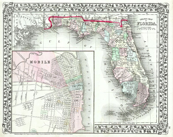
1867 Mitchell Map of Florida (w/ Mobile, Alabama inset)
1867 (dated) $160.00
1874 Mitchell Map of Florida w- Mobile, Alabama inset
FL-m-1874$80.00

Title
County Map of Florida.
1874 12 x 14 in (30.48 x 35.56 cm)
1874 12 x 14 in (30.48 x 35.56 cm)
Description
This hand colored antique map of Florida is a lithographic engraving dating to 1874 by the important American map publisher Samuel Augustus Mitchell, the younger. Map features a large inset of Mobile Alabama, indicating streets and important buildings. Florida itself is shown in considerable detail with interesting references such as 'Indian Hunting Grounds' and 'Mangrove Woods.' Prepared for inclusion in the 1874 issue of Mitchell's New General Atlas. Dated and copyrighted, 'Entered according to Act of Congress in the year of 1874 by S. Augustus Mitchell in the office of the Librarian of Congress at Washington.'
Cartographer
Samuel Augustus Mitchell (March 20, 1792 - December 20, 1868) began his map publishing career in the early 1830s. Mitchell was born in Bristol, Connecticut. He relocated to Philadelphia in 1821. Having worked as a school teacher and a geographical writer, Mitchell was frustrated with the low quality and inaccuracy of school texts of the period. His first maps were an attempt to rectify this problem. In the next 20 years Mitchell would become the most prominent American map publisher of the mid-19th century. Mitchell worked with prominent engravers J. H. Young, H. S. Tanner, and H. N. Burroughs before attaining the full copyright on his maps in 1847. In 1849 Mitchell either partnered with or sold his plates to Thomas, Cowperthwait and Company who continued to publish the Mitchell's Universal Atlas. By about 1856 most of the Mitchell plates and copyrights were acquired by Charles Desilver who continued to publish the maps, many with modified borders and color schemes, until Mitchell's son, Samuel Augustus Mitchell Junior, entered the picture. In 1859, S.A. Mitchell Jr. purchased most of the plates back from Desilver and introduced his own floral motif border. From 1860 on, he published his own editions of the New General Atlas. The younger Mitchell became as prominent as his father, publishing maps and atlases until 1887, when most of the copyrights were again sold and the Mitchell firm closed its doors for the final time. More by this mapmaker...
Condition
Very good condition.
References
Rumsey 2483.024, 0586.026. Newberry Library, A3417. Phillips 1511, 859.