This item has been sold, but you can get on the Waitlist to be notified if another example becomes available, or purchase a digital scan.
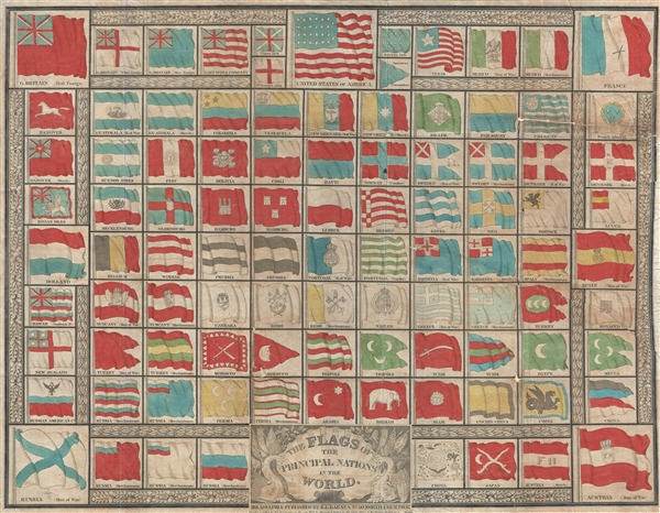
1837 Barnes Broadside Chart of the World's Flags (including Republic of Texas)
FlagsoftheWorld-barnes-1837$450.00

Title
The Flags of the Principal Nations in the World.
1837 (dated) 17.25 x 22.5 in (43.815 x 57.15 cm)
1837 (dated) 17.25 x 22.5 in (43.815 x 57.15 cm)
Description
A beautiful 1837 flag chart issued by R. L. Barnes including the martime ensign of the Republic of Texas. The chart features a total of 98 flags associated with countries in Asia, Africa, America, and Europe. In some cases, both merchant and naval ensigns are included. The chart also includes the ensigns of merchant companies, including the British East India Company and the Russian-American Company.
Flags of Interest
There are several flags of interest, including the Republic of Texas Naval Ensign (1837-1839), two unusual Guatemala (sp. Guatimala) flags, and the flags of two trading companies: the British East Indian Company (potentially the inspiration for the U.S. Flag) and the Russian American Company (a Russian joint stock company that administered Russian interests in Alaska).Publication History and Census
This rare flag chart was published by Rufus L. Barnes in 1837, making it one of his earliest publications. The flag chart was prepared to illustrate the Accompaniment to Mitchell's Map of the World, a volume composed by to supplement and describe Mitchell's great wall map. The copyright identifies Hinman and Dutton, who also hold the copyright on the book. There appear to be two states to this map, the present chart issued by 'Barnes' and another by S. A. Mitchell. Both are dated to 1837, so presumably they were published contemporaneously. The map is uncommon with the OCLC citing only 2 examples of the 'Barnes' issue.CartographerS
Rufus L. Barnes (fl. c. 1840 - 1867) was an American map publisher and seller based in Philadelphia during the early to mid-19th century. Barnes opened a map shop in Philadelphia in 1840 from which issued numerous maps on his account as well as reselling the work of others. Rufus' manuscript ledger, which is preserved in the Newbury Library, reveals connections to most of the prominent map publishers and cartographers of his period, including Robert Pearsall Smith, C.K. Stone, A.R.Z. Dawson, A. Pomeroy & Co., D.J. Lake and Company, Henry F. Walling, S. Willard Treat, John Homer French, R.S. Taintor, Jr. and Co., William Otis Shearer, surveyor Silas N. Beers, engravers Worley and Bracher, A.D. Ellis, Green and Wilbur, and O.W. Gray and Son. His work was used by both sides during the American Civil War and included some of the best Pennsylvania county maps available at the time. Barnes notably partnered with William Ellis Morris to reissue John Melish's important wall map of Pennsylvania in 1848. Barnes sold his business to his assistant John L. Smith in 1867. More by this mapmaker...
Hinman and Dutton (fl. c. 1836 - 1838), possibly Samuel Dutton and William Hinton, were map engravers based in Philadelphia, Pennsylvania in the first half of the 19th century. The firm engraved for several publishers, including Samuel Augusts Mitchell's Sr. in 1837. The firm was based upon 7 Commerce Street in Philadelphia. Learn More...
Source
OCOC 62715485.
Condition
Average. Map exhibits several tears and old fold splits. The whole is not quite square, possibly as issued. Backed on archival tissue for stability.