This item has been sold, but you can get on the Waitlist to be notified if another example becomes available, or purchase a digital scan.
1838 Bradford Map of Florida
Florida-bradford-1838$325.00

Title
Florida.
1838 (dated) 15 x 13 in (38.1 x 33.02 cm) 1 : 2217600
1838 (dated) 15 x 13 in (38.1 x 33.02 cm) 1 : 2217600
Description
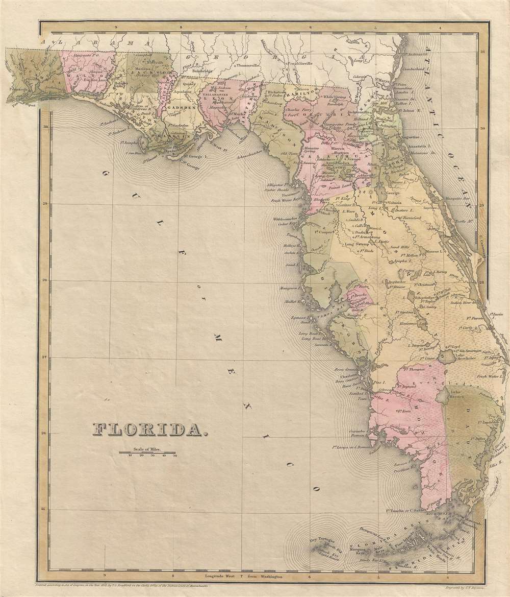
This is a scarce 1838 T.G. Bradford map of Florida. The map depicts all of Florida as it appeared at the height of the Second Seminole War (1835 - 1842). An early Florida county structure is presented with Mosquito County occupying most of eastern Florida. An inset map illustrates the western part of the Florida Panhandle.
Florida Land Grants
Bradford identifies two Land Grants, those of Arredondo and Miranda. Both grants were layovers of the Spanish Land Grant program, which bequeathed them as rewards for service to crown. With incredible difficulty and protest, the land grants were dissolved when Florida became part of the United States. Arredondo's grant, named after Fernando de la Maza Arredondo, is located to the west of St. Augustine in Alachua county. It was granted to Arredondo in 1817 by Alexander Ramirez of Havana. Miranda's Grant, citing Pedro Miranda, a Spanish sailor, is in the vicinity of modern-day Tampa. Both land grants were dissolved by the U.S. Courts on the basis that they were not properly developed and therefore forfeited. These cases were reviews by the courts I 1832 and 1842, respectively. This map was published in Thomas G. Bradford's 1838 Comprehensive Atlas Geographical, Historical and Commercial. The present map may have appeared as early as 1838 when it replaced a smaller scale map of Florida that appeared in earlier editions. This map was engraved by G. W. Boynton of Boston, who also engraved most of the maps for Bradford's later publication. While common in institutional collections, this map is today rare on the market.CartographerS
Thomas Gamaliel Bradford (1802 - 1887) was born in Boston, Massachusetts, where he worked as an assistant editor for the Encyclopedia Americana. Bradford's first major cartographic work was his revision and subsequent republishing of an important French geography by Adrian Balbi, Abrege de Geographie published in America as Atlas Designed to Illustrate the Abridgment of Universal Geography, Modern and Ancient. Afterwards Bradford revised and expanded this work into his own important contributions to American cartography, the 1838 An Illustrated Atlas Geographical, Statistical and Historical of the United States and Adjacent Countries. Bradford's cartographic work is significant as among the first to record Texas as an independent nation. In his long career as a map publisher Bradford worked with William Davis Ticknor of Boston, Freeman Hunt of New York, Charles De Silver of Philadelphia, John Hinton, George Washington Boynton, and others. We have been able to discover little of Bradford's personal life. More by this mapmaker...
George Washington Boynton (fl. c. 1830 - 1850) was a Boston based cartographer and map engraver active in the first half of the 19th century. Boynton engraved and compiled maps for numerous publishers including Thomas Bradford, Nathaniel Dearborn, Daniel Adams, and S. G. Goodrich. His most significant work is most likely his engraving of various maps for Bradford's Illustrated Atlas, Geographical, Statistical, and Historical, of the United States and the Adjacent Countries and Universal Illustrated Atlas. He also engraved for the Boston Almanac. In 1835, Boynton is listed as an employee of the Boston Bewick Company, an engraving, stereotype, and printing concern based at no. 47 Court Street, Boston. Little else is known of his life. Learn More...
Source
Bradford, T. G., A Comprehensive Atlas Geographical, Historical and Commercial (Boston), 1838.
Comprehensive Atlas Geographical, Historical and Commercial. Bradford published this atlas in several editions and with various partners. The first edition, 1835, was published by William D. Ticktor and did not contain the iconic Republic of Texas map (although we have in fact seen Ticktor examples with a Texas map, suggesting, against conventional wisdom, that there may have been two Ticktor editions). The second official edition, published in the same year by the American Stationers Company, was the first to contain the Republic of Texas map, which is based on Austin's map, with two pages of descriptive text. A third edition was issued in 1836, also by American Stationers (though still dated 1835), and contained an unaltered Republic of Texas map with only a single page of descriptive text. In this and all subsequent editions the Florida map was also enlarged. A fourth edition appeared later, possibly 1837, and included an updated and revised map of Texas that replaces the old Mexican land grants with new inchoate counties. Rumsey has an 1838 edition, which he identifies as the 3rd, but its probably the 5th.
Condition
Very good. Even overall toning. Very close right margin. Closed tear extending three quarters of an inch from the right margin professionally repaired on verso. Blank on verso.
References
Rumsey 0089.031.