This item has been sold, but you can get on the Waitlist to be notified if another example becomes available, or purchase a digital scan.
1842 Greenleaf Map of Florida w/ Leigh Read County
Florida-greenleaf-1848$550.00

Title
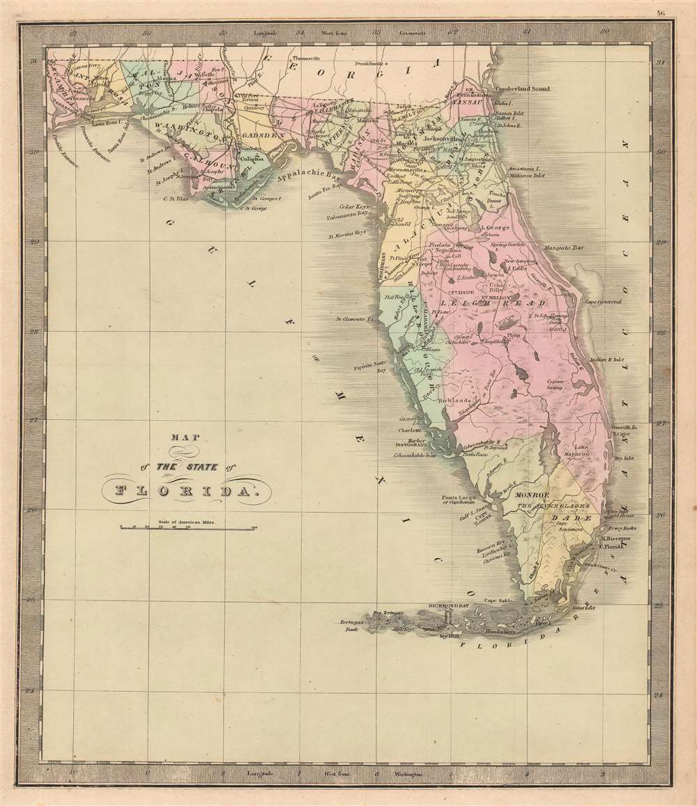
Map of the State of Florida.
1848 (undated) 13 x 11 in (33.02 x 27.94 cm) 1 : 2950000
1848 (undated) 13 x 11 in (33.02 x 27.94 cm) 1 : 2950000
Description
This is Jeremiah Greenleaf’s 1848 map of Florida, notable as being one of the few maps to include the ephemeral Leigh Read County (Mosquito County). The map depicts Florida in full, from the Perdido River to the Atlantic Ocean and from Georgia and Alabama to Key West. Roads connecting the towns, forts, and other settlements are illustrated, along with railroads (there were only 2 at the time) and canals. In addition, the map includes 'Fleming's Grant' on the San Sabastian River, considered a potential new homeland for Irish displaced by the Potato Famine (1845 - 1849).
Leigh Read County
This map is most significant for its inclusion of the ephemeral Leigh Read County, occupying most of east central Florida. In 1842, Florida Democrats proposed a bill that would have renamed 'Mosquito County' (modern-day Orange, Seminole, and Volusia Counties, and parts of Lake, Osceola, Polk, and Brevard) as 'Leigh Read County', in honor of Leigh Read, a recently assassinated general and legislator. The name change was never officially adopted, and accounts differ as to why. Some claim the legislative clerk withheld the bill, others argue that Governor Richard K. Call refused to sign it, still others claim that Governor Call did indeed sign it, 'but through some misadventure the law never appeared on the books'. Regardless, the county did appear on a few maps of the period - see census below.Leigh Read's Adventure
Leigh Read was born in Tennessee, served as a militia general during the Second Seminole War (1835 - 1842), and was a delegate to the Convention of 1837 lobbying for Florida statehood. Read and fellow Florida Democrats passed a constitutional amendment to prohibit the sale of bonds by the territorial government. The bill garnered Read a host of enemies who would have profited from the bond sales, among them former friend, Augustus Alston. In retribution, Alston challenged Read to a duel, a method frequently used by Florida Whigs to dominate territorial politics. Read initially refused the challenge, but, after being ridiculed as a coward, agreed. As the challenged, Read selected the weapon, Yager Rifles, and a site in Georgia (to avoid Florida's dueling ban). Alston, a confident and experienced dueler, told his wife to have a sumptuous dinner ready on his return. On a chilly morning in December 1839, Alston and Read faced off. The dueling protocol called for each to take four steps, turn, and fire. As Read and Alston separated, Alston stumbled and misfired. Read, on the other hand, calmly took aim at Alston's chest and fired, killing him instantly. Alston's sister, it is said, dug the bloody slug out of Alston's chest and sent it to his brother Willis Alston, then living in Texas. Bent on vengeance, Willis Alston travelled to Florida in January 1840 with a new bullet made from the old slug. He found Read at the Brown Hotel celebrating his election as the presiding officer of the territorial legislature. Alston shot Read in the shoulder, but Read returned fire, hitting Alston in the hand. Alston then stabbed Read with a Bowie knife and fled. While Read recovered from this attack, Alston was undeterred, attempting a second attack, firing unsuccessfully into Read's carriage. Alston made a third attempt on Read's life on April 26, 1841. Read was crossing a Tallahassee Street when Alston shot him in the back with a shotgun, followed by a second blast to the chest, killing him. Alston was arrested but allowed to post bond after which he fled to Texas. Shortly thereafter, the hotheaded Alston quarreled with and murdered a popular Texas doctor. A mob of as many as thirty Texans extracted frontier justice, dragged Alston out of town and 'executed him, each man taking a shot'.Leigh Read County on Maps
We are aware of only five instances of Leigh Read County appearing on a published map. The first is the 1842 Sidney Morse and Samuel Breese map of Florida. In 1848, Jeremiah Greenleaf published a map of Florida in a modestly revised edition of his 1842 Universal Atlas, that also identified Leigh Read County. In the 1844 Mitchell / Young wall map of the United States, Leigh Read County appears in the inset map of Florida. In 1845, H. S. Tanner published a map of Florida with Leigh Read County, which was the direct precursor to an 1846 Mitchell Map of Florida.Fleming's Grant - Irish in Florida
George Fleming was an Irishman who in 1816 was awarded a 20,000 acre land grant from the Spanish Government on Florida's east coast, near the San Sabastian River. This, like most other Spanish land grants, were annulled or held up in court when Florida joined the United States in 1821. Most were contested in court for decades, and generally disappeared from maps. The Fleming Grant was affirmed in U.S. Courts in 1845. Nonetheless, the presence here of the comparatively minor Fleming Grant, but no others, is of interest in light of massive Irish immigration to the United States due to the Potato Famine (1845 - 1849). Many Irish, including the Fleming family, settled in Florida and the old grant was seen as a potential new homeland for displaced Irish. The name Fleming also appears further north, on the St. John's River, at the site of modern-day Hibernia.Publication History and Census
This map is from the scarce 1848 edition of Greenleaf's Universal Atlas. The Greenleaf map exists in two states, the first edition issued in 1842, identifies Florida as a 'territory'. This was updated in the 1848 issued to 'state'. It also updated the cartography considerably, replacing Mosquito with 'Leigh Read' County, and adding both Monroe and Dade, among other changes. Rare. We note an example of the atlas, with this map, in the David Rumsey Collection at Stanford. No other examples in the OCLC.Cartographer
Jeremiah Greenleaf (1791 - 1864) is a little known but highly admired American cartographer of the early 19th century. He published from roughly 1830 to 1850. His most important work is A New Universal Atlas; Comprising of all the Principal Empires, Kingdoms, and States Throughout the World and Forming a distinct Atlas of the United States, published in several editions in the 1840s. Many of his maps are reformatted versions of his contemporary David Burr's much admired cartographic works. Greenleaf's maps are extremely rare and admired for their stunningly vivid pastel color washes. More by this mapmaker...
Source
Greenleaf, J. New Universal Atlas (Brattleboro, Vermont: Greenleaf), 1842.
Condition
Very good.
References
OCLC 727083405. Rumsey 2866.056.