This item has been sold, but you can get on the Waitlist to be notified if another example becomes available, or purchase a digital scan.
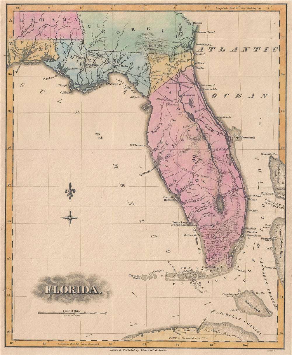
1823 Fielding Lucas Map of Florida
Florida-lucas-1823$625.00

Title
Florida.
1823 (undated) 12 x 9.75 in (30.48 x 24.765 cm) 1 : 3674880
1823 (undated) 12 x 9.75 in (30.48 x 24.765 cm) 1 : 3674880
Description
This is an 1823 Fielding Lucas, Jr. map of Florida published only two years after Florida's incorporation into the United States as a territory. The map depicts the region from the Perdido River to the Great Bahama Bank and from Georgia and Alabama to Cuba. Reminiscent of the 1823 map of Florida by H.S. Tanner, Florida's coastline is illustrated in significant detail, with numerous inlets and capes labeled, including Cape Canaveral. Tampa Bay is also illustrated, although here it is labeled as Spirito Santo Bay. Pensacola, Jacksonville, and St. Augustine are identified, as are numerous smaller settlements.
Fort Gadsden
Fort Gadsden, along the Apalachicola River, is noted. This fort was erected on the site of a former British fort that was demolished by the Americans during the War of 1812 when a shell landed on the ammunition depot, killing all but thirty-three of the 300 African-Americans defending the fort. Fort Gadsden was an outpost of United States Army in the heart of Spanish Florida until 1821, when Florida became a U.S. Territory. Fort St. Marks and Fort Poppa are also identified.St. John's River
Although sparsely illustrated, the St. John's River, the longest river in Florida, dominates the depiction of peninsular Florida, labeled here as St. John's County. The river is illustrated extending from Mayaco Lake in southern Florida north past Saint Augustine and Jacksonville until it empties into the Atlantic near Talbot Island. Lucas correctly illustrates the many lakes and smaller rivers that are part of the river system, along with the wetlands that stretch out from the river's banks. An Indian path and an Indian Ferry are some of the only noted details, along with numerous rivers.Census and Publication History
This map was engraved by B. Welch and published by Fielding Lucas, Jr. for his General Atlas in 1823. A second edition without updates was issued in 1826. Today Lucas's atlas and this map specifically are exceedingly rare on the market.Cartographer
Fielding Lucas Jr. (September 3, 1781 - March 12, 1854) was an American cartographer, chartmaker, and publisher active in Baltimore during the first half of the 19th century. Born in Fredericksburg, Virginia, little is known of Lucas's family and early life, but his lineage seems to have been established in Fredericksburg from at least the mid-1700s. Lucas founded Lucas Brothers, one of America's first stationers located at 116 East Baltimore Street, in 1804 and later, in 1806, he became the Baltimore manager of the Philadelphia based publishing firm Conrad, Lucas, and Company. Lucas is also known to have worked with the Matthew Carey firm in Philadelphia. Lucas entered the map trade around 1814, when he published an atlas of the United States - similar to, but in direct competition with, Matthew Carey, a matter which soured an otherwise profitable friendship. In 1825, Lucas also produced a world atlas. Over the course of his career, Lucas published several smaller atlases and numerous independent issue maps, including an important nautical chart of the Chesapeake and Delaware Bays. Many of his maps were engraved by H. S. Tanner, but he also worked with Robert Mills (Atlas of South Carolina) and others. Lucas attained considerable social prominence as a patron of the arts and philanthropist. He was a member of the committee that helped build Baltimore's Washington Monument and was one of the founding members of the Boston Harmonic Society and the Maryland Institute for the Promotion of Mechanical Arts. During the War of 1812, Lucas enlisted in Captain John Kanes' Company, 27th Maryland Regiment, although little is known of his actual service. From 1827 he served as a director of the Baltimore and Ohio Railroad and, later, as director of the Baltimore and Rappahannock Steam Packet Company. He died in Baltimore on March 12, 1854. (Foster, J. W., Fielding Lucas, Jr., Early 19th Century American Publisher of Fine Books and Maps, 'American Antiquarian Society', October 1955, Volume 64, Part 2, 162-212) More by this mapmaker...
Source
Lucas, Fielding Jr., A General Atlas Containing Distinct Maps Of all the Known Countries in the World, (Baltimore: Fielding Lucas) 1823.
Condition
Very good. Even overall toning. Blank on verso.
References
Rumsey 4584.072. OCLC 48766591.