
This item below is out of stock, but another example (left) is available. To view the available item, click "Details."
Details
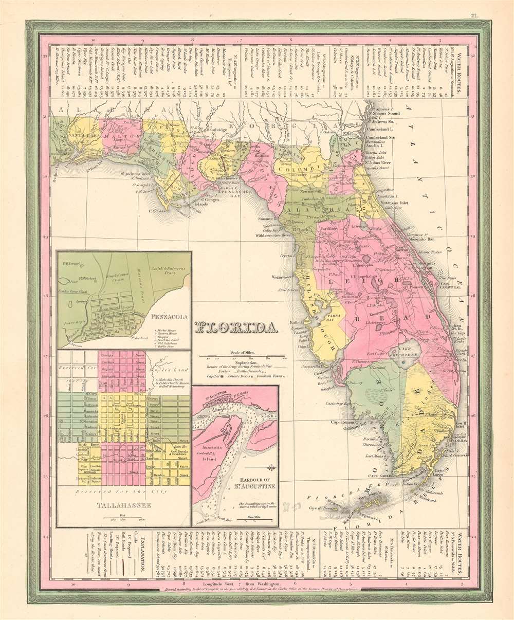
1867 Mitchell Map of Florida (w/ Mobile, Alabama inset)
1867 (dated) $160.00
1846 Mitchell / Tanner 1st Edition Map of Florida w/ Leigh Read County!
Florida-mitchell-1846$375.00

Title
Florida.
1839 (dated) 15 x 12 in (38.1 x 30.48 cm) 1 : 316800
1839 (dated) 15 x 12 in (38.1 x 30.48 cm) 1 : 316800
Description
This is a first edition 1846 Samuel Augustus Mitchell and Henry Schenck Tanner map of Florida, notable as being one of the few maps to include the ephemeral Leigh Read County (Mosquito County). The map depicts Florida in full, from the Perdido River to the Atlantic Ocean and from Georgia and Alabama to Key West. Roads connecting the towns, forts, and other settlements are illustrated, along with railroads (there were only 2 at the time) and canals. Inset maps in the lower left corner detail the cities of Pensacola and Tallahassee and the harbor of St. Augustine. Information concerning water routes is included along the top and bottom borders. The whole is surrounded by the Carey and Hart border, which Mitchell only used in this first edition of the atlas.
The Seminole were a composite tribe formed from various southeastern American Indian tribes that were relocated to a large reservation in Central Florida. These included the Alabamas, Choctaw, Yamasees, Yuchis and Creek people, as well as escaped slaves.
In 1834 the United States government forced the Seminole to sign the Treat of Payne's Landing, which gave the tribe three years to move west of the Mississippi and join the Creek in the Indian Territory. The Seminole, rightly claiming unfair negotiations, renounced the treaty and, instead of moving west, entrenched themselves in the Florida swamps. The subsequent war proved long and bloody, with neither side gaining a solid early advantage. Ultimately, the superior resources and numbers of the United States military proved decisive. Most of the Seminole were removed to the Indian Territory (Oklahoma) while the remaining Seminole in Florida settled in large informal reservation located between Lake Okeechobee and Tampa.
Due to a long publication run, confusing publication history, and lack of serious research, Mitchell atlas maps are considered 'common.' Nonetheless, the first edition, with the Carey and Hart borders, is in fact quite rare and some of the unique maps from that edition of the atlas, like the present 'Leigh Read' Florida are both cartographically significant and scarce.
Leigh Read County
This map is most significant for its inclusion of the ephemeral Leigh Read County, occupying most of east central Florida. In 1842, Florida Democrats proposed a bill that would have renamed 'Mosquito County' (modern-day Orange, Seminole, and Volusia Counties, and parts of Lake, Osceola, Polk, and Brevard) as 'Leigh Read County', in honor of Leigh Read, a recently assassinated general and legislator. The name change was never officially adopted, and accounts differ as to why. Some claim the legislative clerk withheld the bill, other argue that Governor Richard K. Call refused to sign it, still others claim that Governor Call did indeed sign it, 'but through some misadventure the law never appeared on the books'. Regardless, the county did appear on a few maps of the period - see census below.Leigh Read
Leigh Read was born in Tennessee, served as a militia general during the Second Seminole War (1835 - 1842), and was a delegate to the Convention of 1837 lobbying for Florida statehood. Read and fellow Florida Democrats passed a constitutional amendment to prohibit the sale of bonds by the territorial government. The bill garnered Read a host of enemies who would have profited from the bond sales, among them former friend, Augustus Alston. In retribution, Alston challenged Read to a duel, a method frequently used Florida Whigs to dominate territorial politics. Read initially refused the challenge, but, after being ridiculed as a coward, finally agreed. As the challenged, Read selected the weapon, Yager Rifles, and a site in Georgia (to avoid Florida's dueling ban). Alston, a confident and experienced dueler, and told his wife to have a sumptuous dinner ready on his return. On chilly morning in December 1839, Alston and Read faced off. The dueling protocol called for each to take four steps, turn, and fire. As Read and Alston separated, Alston stumbled and misfired. Read, on the other hand, calmly took aim at Alston's chest and fired, killing him instantly. Alston's sister, it is said, dug the bloody slug out of Alston's chest and sent it to his brother Willis Alston, then living in Texas. Bent on vengeance, Willis Alston travelled to Florida in January 1840 with a new bullet made from the old slug. He found Read at the Brown Hotel celebrating his election as the presiding officer of the territorial legislature. Alston shot Read in the shoulder, but Read returned fire, hitting Alston in the hand. Alston then stabbed Read with a Bowie knife and fled. While Read recovered from this attack, Alston was undeterred, attempting a second attack, firing unsuccessfully into Read's carriage. Alston made a third attempt on Read's life on April 26, 1841. Read was crossing a Tallahassee street when Alston shot him in the back with a shotgun, followed by a second blast to the chest, killing him. Alston was arrested, but allowed to post bond after which he fled to Texas. Shortly thereafter, the hotheaded Alston quarreled with and murdered a popular Texas doctor. A mob of as many as thirty Texans extracted frontier justice, dragged Alston out of town and 'executed him, each man taking a shot'.Leigh Read County on Maps
We are aware of only five instances of Leigh Read County appearing on a published map. The first is the 1842 Sidney Morse and Samuel Breese map of Florida. Later that same year, Jeremiah Greenleaf published a map of Florida that also identified Leigh Read County. In the 1844 Mitchell / Young wall map of the United States Leigh Read county appears in the inset maps of Florida. In 1845, H. S. Tanner published a map of Florida with Leigh Read County, which was the direct precursor of the currently offered 1846 Mitchell Map of Florida.Second Seminole War
Fought between 1835 and 1842, the Second Seminole War was a conflict between the United States Government and the various American Indian groups known collectively as the Seminole. Fought primarily in peninsular Florida, the Second Seminole War was the most significant of the three Seminole Wars, and the longest Indian War in U.S. history.The Seminole were a composite tribe formed from various southeastern American Indian tribes that were relocated to a large reservation in Central Florida. These included the Alabamas, Choctaw, Yamasees, Yuchis and Creek people, as well as escaped slaves.
In 1834 the United States government forced the Seminole to sign the Treat of Payne's Landing, which gave the tribe three years to move west of the Mississippi and join the Creek in the Indian Territory. The Seminole, rightly claiming unfair negotiations, renounced the treaty and, instead of moving west, entrenched themselves in the Florida swamps. The subsequent war proved long and bloody, with neither side gaining a solid early advantage. Ultimately, the superior resources and numbers of the United States military proved decisive. Most of the Seminole were removed to the Indian Territory (Oklahoma) while the remaining Seminole in Florida settled in large informal reservation located between Lake Okeechobee and Tampa.
The Second Seminole War on this Map
Movements of United States Army in southern Florida are traced and illustrated. Important forts are identified throughout. Several battles are referenced simply by date, and one, Dade's Massacre, by name. Dade's Massacre was a defeat of U.S. Army by the Seminole wherein 110 soldiers, led by Major Francis L. Dade, were ambushed and slaughtered.Publication History and Census
This map was engraved by J. H. Young and first published by Henry Schenck Tanner in 1839. Under Tanner and 'Carey and Hart', who acquired the map plate in the 1840s, the map went through several states and significant revisions. Carey and Hart added their distinctive border and published the first edition to include a proposed Leigh Read County, in 1845. Carey and Hart subsequently sold the map plates to Samuel Augustus Mitchell Sr. in 1845. Mitchell used them as the basis the 1846 first edition of his A New Universal Atlas. Later in 1846 he issued a second edition, replacing the Carey and Hart borders with his own distinctive strapwork border. Mitchell himself revised the plate several times to keep currently with fast-changing Florida politics before selling it to Thomas Cowperthwait and Company, who continued to publish the 'Mitchell' atlas until the late 1850s.Due to a long publication run, confusing publication history, and lack of serious research, Mitchell atlas maps are considered 'common.' Nonetheless, the first edition, with the Carey and Hart borders, is in fact quite rare and some of the unique maps from that edition of the atlas, like the present 'Leigh Read' Florida are both cartographically significant and scarce.
CartographerS
Samuel Augustus Mitchell (March 20, 1792 - December 20, 1868) began his map publishing career in the early 1830s. Mitchell was born in Bristol, Connecticut. He relocated to Philadelphia in 1821. Having worked as a school teacher and a geographical writer, Mitchell was frustrated with the low quality and inaccuracy of school texts of the period. His first maps were an attempt to rectify this problem. In the next 20 years Mitchell would become the most prominent American map publisher of the mid-19th century. Mitchell worked with prominent engravers J. H. Young, H. S. Tanner, and H. N. Burroughs before attaining the full copyright on his maps in 1847. In 1849 Mitchell either partnered with or sold his plates to Thomas, Cowperthwait and Company who continued to publish the Mitchell's Universal Atlas. By about 1856 most of the Mitchell plates and copyrights were acquired by Charles Desilver who continued to publish the maps, many with modified borders and color schemes, until Mitchell's son, Samuel Augustus Mitchell Junior, entered the picture. In 1859, S.A. Mitchell Jr. purchased most of the plates back from Desilver and introduced his own floral motif border. From 1860 on, he published his own editions of the New General Atlas. The younger Mitchell became as prominent as his father, publishing maps and atlases until 1887, when most of the copyrights were again sold and the Mitchell firm closed its doors for the final time. More by this mapmaker...
Henry Schenck Tanner (1786 - May 18, 1858) was one of the preeminent American map engravers and publishers of the early 19th century - what is considered to be the "Golden Age of American Map Publishing". Born in New York City but based in Philadelphia, Tanner's forty plus year career was almost entirely focused on cartographic work. His earliest map work appears in conjunction with another important map publisher, John Melish. Early in his career, Tanner partnered with his brother Benjamin, to engrave extensively for Melish as well as other Philadelphia publishers including Lucas Fielding (Baltimore), A. Bourne, Jason Torey, Samuel Harrison, and Samuel Lewis, among others. In 1818 Tanner convinced his fellow publishers and partners to finance the compilation of a New American Atlas. The atlas was sold by subscription and slowly emerged between 1819 and 1823. The New American Atlas, possibly the pinnacle of 19th century American cartography and was commended in its day as "one of the most splendid works of the kind ever executed in this country". It was subsequently republished in several updated editions until about 1839. Tanner had by this time become the most active and influential map publisher in the United States. Around 1832, recognizing the market for a less cost prohibitive atlas, Tanner began work on the smaller format New Universal Atlas. This popular and important atlas went through numerous editions before being bought out by Carey and Hart, and then, in 1846, by S. A. Mitchell, who would rise to become the preeminent publisher of the next generation. In addition to these important atlases, Tanner also issued numerous extremely important and influential travelers guides, state maps, wall maps, and pocket maps. He should not be confused with his brother, also an America map engraver, the New Yorker Benjamin Tanner. Learn More...
Source
Mitchell, S.A., A New Universal Atlas Containing Maps of the various Empires, Kindoms, States, and Republics of the World…(Philadelphia: Mitchell) 1846.
The New Universal Atlas is one of the great American atlases of the mid-19th century. Samuel Augustus Mitchell first issued the atlas in 1846 when he acquired the map plates and copyright for Tanner's New Universal Atlas from its publisher, Carey and Hart. The first transitional 1846 edition was published jointly with Carey and Hart, but a second edition was published in the same year with the Tanner imprint erased. This edition of the atlas also introduced the signature S. A. Mitchell green and pink color scheme. Most of the maps from the early editions of the atlas were engraved by H. N. Burroughs or C. S. Williams, often bearing their copyright. Burroughs maps also tended to have what map collector David Rumsey refers to as the 'Cary and Hart' borders, which featured a narrow vine motif. These borders were replaced, along with the Burroughs imprint, with the more traditional Mitchell strap work border used in the atlases until 1856. Mitchell published editions until late in 1850, when he sold the rights to Thomas, Cowperthwait and Company of Philadelphia. Under Cowperthwait, the atlases continued to be published and bear the Mitchell name until 1856, when the plates were again sold, this time to Charles Desilver. Desilver reworked the plates with new border art and a revised color scheme in the style of J. H. Colton. Desilver issued editions from 1857 to 1860, when the atlas was phased out in favor of Samuel Augustus Mitchell Jr.'s New General Atlas.
Condition
Very good. Even overall toning. Blank on verso.