This item has been sold, but you can get on the Waitlist to be notified if another example becomes available, or purchase a digital scan.
1844 E. and G.W. Blunt Nautical Chart or Map of Florida, Cuba, and the Bahamas
FloridaCubaBahamas-blunt-1844$2,250.00

Title
Southern Coast, U. States. Sheet VIII. / Cuba and the Windward Passages. / Southern Coast.. U. States. Sheet VII.
1844 (dated) 81 x 41 in (205.74 x 104.14 cm) 1 : 864000
1844 (dated) 81 x 41 in (205.74 x 104.14 cm) 1 : 864000
Description
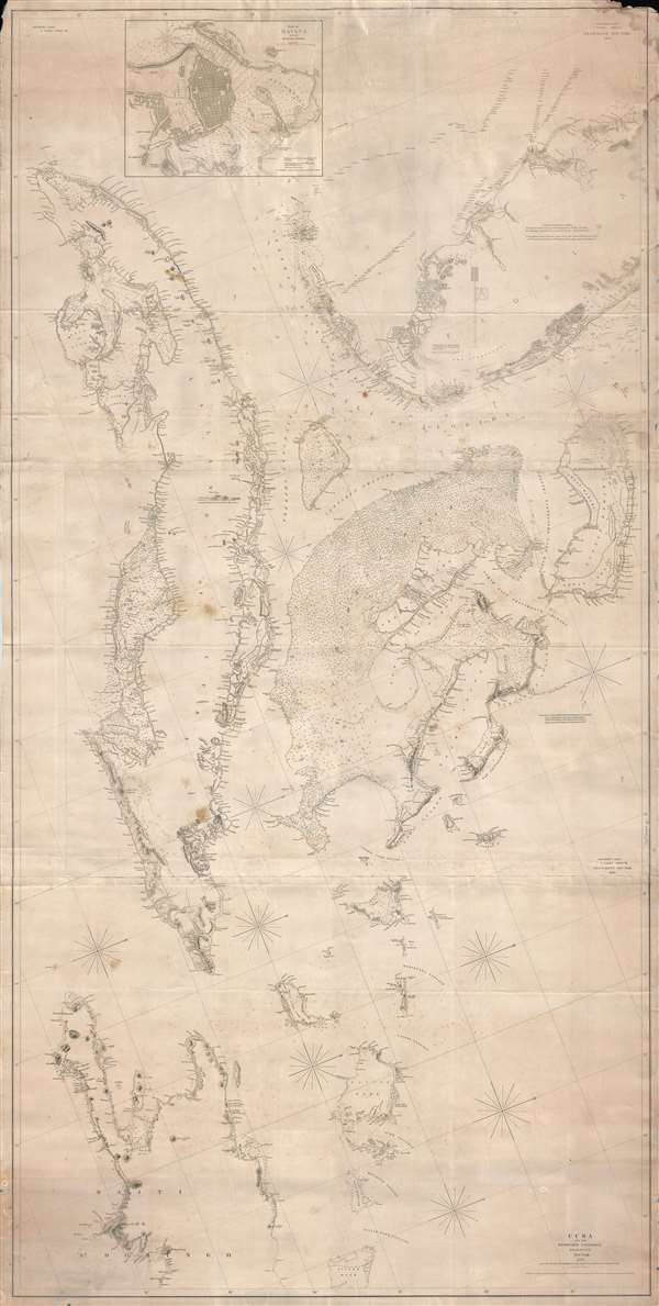
An enormous and expansive 1844 - 1857 nautical chart or maritime map of Southern Florida, the Bahamas, and Cuba. Curiously oriented to the northeast, this sprawling map covers from central Florida in the vicinity of Tampa Bay, to western Hispaniola (Santo Domingo, or modern day Haiti), including all of Cuba and most of the Bahamas. Blunt designed his charts to be joined to create massive maps custom tailored to each voyage. The present chart is no exception, being in fact a joined composite of three charts: Blunt's United States Southern Coast Sheet VII (1844), Blunt's United States Southern Coast Sheet VIII (1844), and a slightly newer chart, Cuba and the Windward Passages (1857).
The upper panel, containing Florida, is beautifully detailed with both nautical and coastal terrestrial detail. It identifies Hutchinson's Island, St. Lucie Sound, Fort Pierse, Fort Jupiter, the Boca Ratones, Fort Lauderdale, Biscayne Key, and Cape Florida (vicinity of Miami). In western Florida it identifies Charlott's Harbor, Tampa Bay (where a large military reserve surrounding Fort Brooke is identified), Fort Cross, and Fort Harrison. The Florida Keys are fully represented with lights on Key West, Sand Key, in the Tortugas, and on Sombrero Key. This sheet also includes western Cuba and contains a detailed inset of Havana.
The middle panel or sheet focuses on central Cuba and the Bahama Islands and is exceptionally rich in sounding and nautical detail, specifically on the Grand Bahama Bank. This map contains pencil note clearly referring to navigation between the Bahama Islands and The Dry Tortugas. The purpose of the voyage is unclear, but the map specifically identifies a location just north of the Dry Tortugas as, seemingly, the terminus of the voyage.
The lower panel, or eastern sheet, dated in 1857, was presumably added later, but meshes perfectly with the two 1844 charts. It details eastern Cuba and the western part of the Island of Hispaniola or Santo Domingo - a region roughly equivalent to modern day Haiti.
This map is owned jointly by Geographicus and Vetus Carta Maps.
Cartographer
Edmund March Blunt (June 20, 1770 - 1862) was an American navigator, bookseller, chartmaker, and cartographer based in Newburyport, Massachusetts. Blunt was born in Portsmouth, New Hampshire in 1770. In 1796, along with the nominal assistance of prominent navigator Captain Lawrence Furlong, Blunt published The American Coast Pilot, one of the most important published works on American navigation. Although much of the work was plagiarized from British publications, the Coast Pilot was an immediate popular success. In response to the popularity of his work, Blunt published 21 subsequent editions, each with important updates and revisions. The first edition to contain map plates was printed in 1804. Following a fire that destroyed his offices at The Sign of the Bible in 1811, Blunt moved his business to New York and opened a new shop, The Sign of the Quadrant. His sons Edmund Jr. (1799 - 1866) and George William (1802 - 1878), joined the firm in 1824 and eventually took over the family business, renaming the firm 'E. and G. W. Blunt'. They both produced their own nautical books, charts, and instruments, as well as republished their father’s work. In 1830, Edmund accepted a position under Ferdinand Hassler at the United States Office of the Coast Survey. Much of Blunt's original work eventually found its way into U.S. Coast Survey Publications. George closed the firm in 1872 and sold the plates and chart copyrights to the U.S. Coast Survey and the U.S. Navy Hydrographic Office. Due to the quality and detail of Blunt's work, revised editions of his most important charts were republished well into the 1880s. More by this mapmaker...
Condition
Good. A couple of minor verso repairs. Backed on blue paper. Minor loss to upper right and left corners, not affecting printed map. Even overall toning. Slight staining and creasing.