
This item below is out of stock, but another example (left) is available. To view the available item, click "Details."
Details
1914 Florida East Coast Railway Railroad Map of Florida
1914 (dated) $1,200.00
1903 Florida East Coast Railway Railroad Map of Florida
FloridaEastCoastRail-matthewsnorthrup-1903$600.00


Title
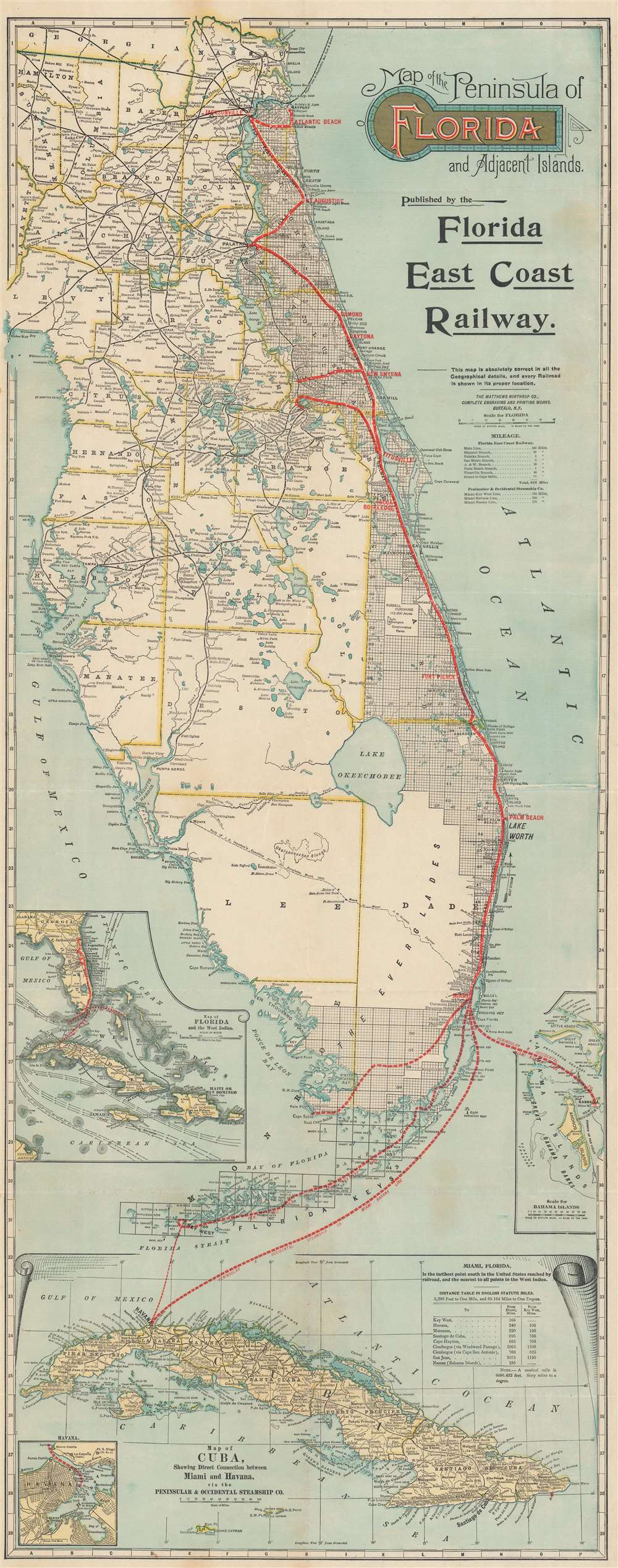
Map of the Peninsula of Florida and Adjacent Islands.
1903 (dated) 40 x 16 in (101.6 x 40.64 cm) 1 : 887000
1903 (dated) 40 x 16 in (101.6 x 40.64 cm) 1 : 887000
Description
A highly decorative 1903 map of Peninsular Florida issued by the Mathews-Northrup Company for Henry Morrison Flagler’s (1830 – 1913) Florida East Coast Railway. The map covers from the Georgia border to Key West and Cuba, and from Cedar Key to the Bahamas. The route of the railroad is illustrated in red overprinting extending from Jacksonville to just south of Miami, with major stops noted. The map also identifies drainage canals from Lake Okeechobee constructed by J. O. Wright to drain the Everglades. The routes of the Peninsular and Occidental Steamship Company from Miami to Key West, Havana, and Nassau are illustrated by thick dashed lines. Inset maps focus on the Bahamas, the West Indies, and Cuba.
Dating this Map
Since this map is undated, one must use the content of the map to arrive at a date. The Peninsular and Occidental Steamship Company was inaugurated on July 24, 1900, after the Florida East Coast Steamship Company and the Plant Steamship services merged, and operated for the next six and a half decades. The Florida East Coast Railway acquired the Enterprise Branch between Titusville and Enterprise Junction in 1902 from the Southeastern Railway. In 1903, the Florida East Coast Railway extended its line twelve miles south of Miami to better serve the agricultural community, and that extension is illustrated here. However, it does not reach as far south as Homestead, which the Florida East Coast Railway reached in 1904.The Florida East Coast Railway
The Florida East Coast Railway was a major force in the development of Eastern Florida in the late 19th and early 20th century. Spearheaded by the industrialist Henry Flagler (1830 - 1913), the Florida East Coast Railway fulfilled a vision dating back at least to the 1870s. Before Flagler, Florida south of Jacksonville was serviced by only a few rickety railroads unconnected to one another. Most access to Florida cities was limited to ferry and steamer services. Flagler bought up most of the failing existing railroads, upgraded them, and connected them with new lines, formally consolidating the network first as the 'Jacksonville, St. Augustine, and Indian River Railway', and then, on September 9, of 1895, as the 'Florida East Coast Railway'.The Empire Grows
The railroad reached New Smyrna in 1892, Cocoa in 1893, Palm Beach in 1894, and Miami in 1896. Flagler constructed sumptuous resorts and founded cities all along the route, among them The Ormond, the Royal Palm, the Royal Poinciana, the Continental, and more. Combined with his railroads, and the Peninsular and Occidental Steamship Company (P. and O. S.S.), Flagler commanded a resort empire spanning the entire east cost of the Florida peninsulaThe Key West Extension
The extension to Key West, possibly the greatest Railroad achievement of the era, was planned from about 1895, but not completed until 1912. It operated for little more than 20 years, heralding a golden age for the Key West and the Florida Keys in general. Business magnates, presidents, and dignitaries rode the rails to Miami or Key West before embarking with Flagler’s Peninsular and Occidental Steamship Company to Havana, Cuba, and the Bahamas. Long after Flagler’s death, the Labor Day Hurricane of 1935 destroyed some of the railroad bridges leading to Key West (the remains of which can still be seen) and the FEC, then insolvent, was unable to finance the repairs. The tracks were donated to the state, who used the infrastructure to construct the Overseas Highway (U.S. 1).Census and Publication History
There are multiple states of this map reflecting the development of the Florida East Coast Railway. We note only one other verifiable cataloged example of the present state of this map, which is part of the collection at the Touchton Map Library, although it is dated to 1908. The Library of Congress owns an example of the earliest known state, published for the 'Jacksonville, St. Augustine, and Indian River Railway', with the railroad terminating at Palm Beach, and a date of 1893. Rumsey’s example of 1896 sees the name changed to Florida East Coast Railroad, and shows tracks extending as far as Miami, with planned extensions as far as Key West. The Tampa Bay History Center, Touchton Map Library, owns an example showing the track extending as far as Key West dating to 1913. A more extensive version was published by the Florida Land Department in 1924, showing all railroads and roads in the peninsula.Cartographer
Matthews-Northrup Works (fl. c. 1895 - 1930) were a Buffalo, New York based, in their own words, "writing, designing, engraving, printing, [and] binding" firm. The firm was founded by James Newson Matthews (November 21, 1828 - December 20, 1888) as the J. N. Matthews Company. William Phelps Northrup (April 2, 1850 - February 2, 1929) later joined the company as an apprentice and then partner, at which point the firm was reincorporated as the Matthews-Northrup Works. The Matthews-Northrup Works rose to prominence as publishers and printers of railroad maps, with dozens to their credit. When James died, his shares were inhered by George Edward Matthews (1855 - 1910), who ran the business until his death in 1910. Also in 1910, they famously redesigned the cover of National Geographic Magazine. Despite some six previous cover changes in just 21 years, the Matthews-Northrup layout proved so popular that it was used for nearly 50 years. The firm can also take credit for the Winchell typeface, designed in 1903 under E. E. Winchell's tenure as art director. Curiously, the partners of Matthews-Northrup maintained an unusual affectation in which only the officers of the company could wear beards or mustaches. In this same spirit, the firm also had its own private social club, the Fellowcraft Club, where the all-male employees could relax, play pool, drink and dine. Matthews-Northrup maintained offices on Washington Street, Buffalo, where they were based, as well as Madison Square, New York City, Garden Tower, Boston, and the Citizens Building in Cleveland. More by this mapmaker...
Condition
Very good. Exhibits wear along original fold lines. Verso repairs to fold separations and at fold intersections. Exhibits two areas of minor infill at two fold intersections.
References
Tampa Bay History Center, Touchton Map Library L2018.078.033 (dated c. 1908). Library of Congress, G3931.P3 1893 .J3. Rumsey 3893.000. Modelski, A., Railroad Maps of North America: The First Hundred Years, #36.