This item has been sold, but you can get on the Waitlist to be notified if another example becomes available, or purchase a digital scan.
1884 Colton / Florida Land and Mortgage Company Map of Florida
FloridaLandMortgage-colton-1884$1,500.00

Title
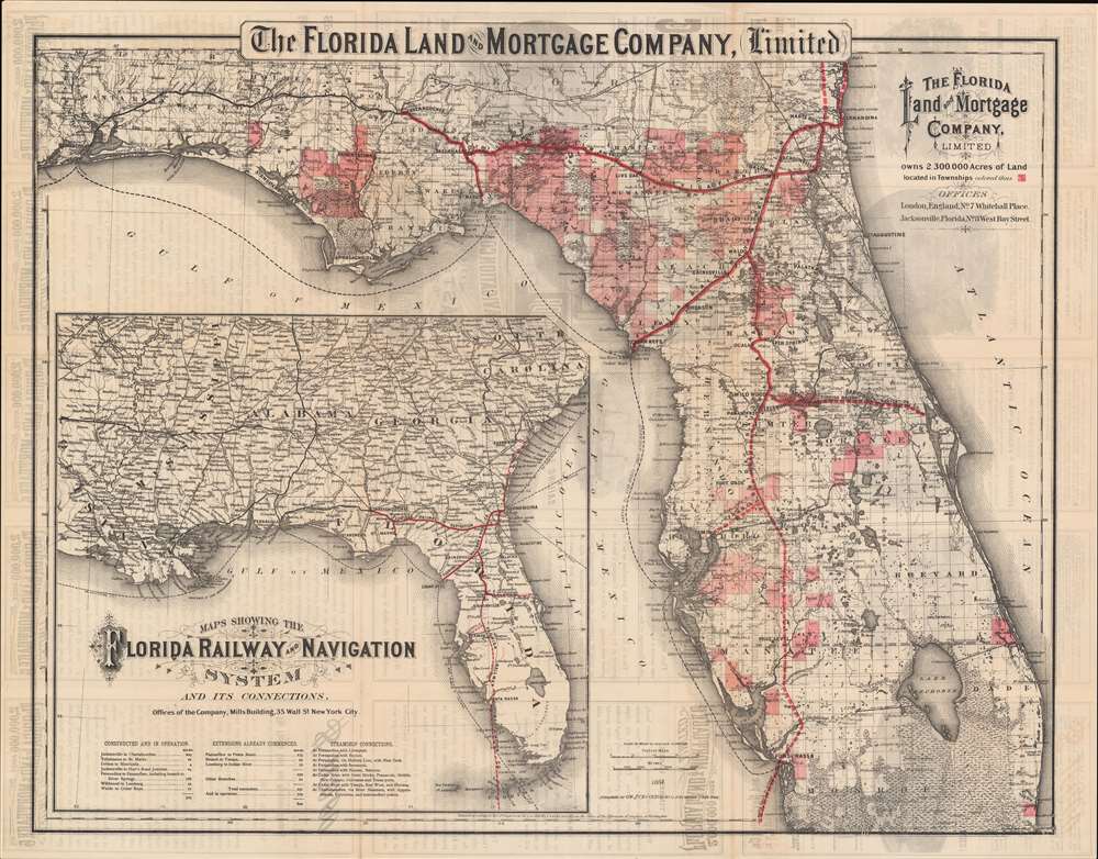
The Florida Land and Mortgage Company, Limited owns 2,300,000 Acres of Land...
1884 (dated) 20 x 26 in (50.8 x 66.04 cm) 1 : 1140000
1884 (dated) 20 x 26 in (50.8 x 66.04 cm) 1 : 1140000
Description
The map that launched the first Florida land boom. This important 1884 map of Florida was issued by the Colton firm for the Florida Land and Mortgage Company. The map captures the beginnings of the first Florida Land Boom (1881 - 1894), illustrating the vast Hamilton Disston (1844 - 1896) and Edward James Reed (1830 - 1906) real-estate empire. Operating as the Florida Land and Mortgage Company, Disston and Reed redefined central and western Florida.
Repaying Florida Debt
In the decades following the American Civil War (1861 - 1865), Florida, like many southern states, found itself strapped by debt. At the same time, Florida was seen as pristine untouched fertile land, ripe for colonization, cultivation, and investment. Governor George Franklin Drew and the Florida legislature concocted a scheme to sell state lands to private investors who would, it was hoped, proceed with settlement and infrastructure improvement. In 1881 the Internal Improvement Fund of Florida contracted to transfer some 4,000,000 acres of land, roughly 1/9th the state, to the Philadelphia financier Hamilton Disston. The sale resolved Florida's state debt issue.Improving the Land
Disston immediately partnered with the English industrialist Edward James Reed and the Dutchman Jacobus Wertheim, who jointly assumed half of Reed's debt to Florida, forming the Florida Land and Mortgage Company, Ltd. These gentlemen chose the best available lands in the state. To augment their real estate, they also acquired the Atlantic Gulf and West India Transit Company (Fernandina to Cedar Key), the Peninsular Railroad (Ocala to Waldo), and the Tropical Florida Railroad (Ocala to Wildwood), which were merged into the Florida Transit and Peninsular Railroad. Other railroads and ferry lines were added, forming the broad and projected railroad network on display here. In addition, he began extensive land reclamation projects throughout his vast land holdings, but most particularly in central Florida. By 1893 Disston and company conveyed about 1,200,000 acres of reclaimed land and lowered the level of Lake Okeechobee by about 4 1/2 feet.The First Florida Land Boom (1881 - 1894)
The work of the Florida Land and Mortgage Company, the attendant railroads, and Disston's various private enterprises, including the Disston Land Company and St. Cloud Sugar Plantation, inaugurated Florida's first major land boom. Claiming to own 1/3rd of the state, Disston, lured homesteaders and investors with real estate offices across America as well as England, Scotland, Germany, Italy, Sweden and Denmark. He used his political clout to convince presidents, other politicians, and celebrities to vacation in Florida, thus fostering cache and allure. Land prices soared and investors in the United States and abroad were increasingly excited by the prospective gains. Luminaries like Henry Ford and Thomas Edison built lavish homes in Fort Meyers.Crash and Burn
Economic enthusiasm came crashing down with the Panic of 1893, which devastated the national economy. In Florida, the situation was compounded by severe freezes in 1894 and 1895 that devastated both sugar and citrus production. Fledgling towns, plantations, and communities throughout Florida failed, many turning permanently into ghost towns Disston himself fell into destitution and took up riverboat gambling before committing suicide at 51.Verso Content
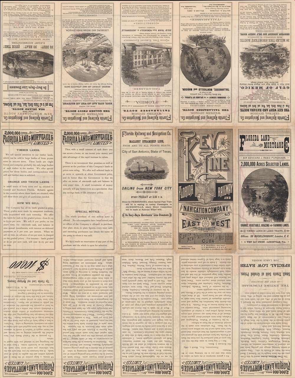
The verso of this map features promotions describing the lands offered by the Florida Land and Mortgage Company. It praises the vastness, diversity, and low costs of Florida land. Curiously, all of the promotions focus on Reed, suggesting that he financed the map's production, possibly for a British audience.Publication History and Census
This map was drafted by G. W. and C. B. Colton for the Florida Land ad Mortgage Company in 1884. It was printed in New York by Leve and Alden Printing, 107 Liberty Street. Examples are scarce, but we do note one at the Tampa Bay History Center's Touchton Collection.CartographerS
Joseph Hutchins Colton (July 5, 1800 - July 29, 1893), often publishing as J. H. Colton, was an important American map and atlas publisher active from 1833 to 1897. Colton's firm arose from humble beginnings when he moved to New York in 1831 and befriended the established engraver, Samuel Stiles. He worked under Stiles as the 'Co.' in Stiles and Co. from 1833 to 1836. Colton quickly recognized an emerging market in railroad maps and immigrant guides. Not a cartographer or engraver himself, Colton's initial business practice mostly involved purchasing the copyrights of other cartographers, most notably David H. Burr, and reissuing them with updated engraving and border work. His first maps, produced in 1833, were based on earlier Burr maps and depicted New York State and New York City. Between 1833 and 1855, Colton proceeded to publish a large corpus of guidebooks and railroad maps, which proved popular. In the early 1850s, Colton brought his two sons, George Woolworth Colton (1827 - 1901) and Charles B. Colton (1832 - 1916), into the map business. G. W. Colton, trained as a cartographer and engraver, was particularly inspired by the idea of creating a large and detailed world atlas to compete with established European firms for the U.S. market. In 1855, G.W. Colton issued volume one of the impressive two-volume Colton's Atlas of the World. Volume two followed a year later. Possibly because of the expense of purchasing a two-volume atlas set, the sales of the Atlas of the World did not meet Colton's expectations, and so, in 1856, the firm also issued the atlas as a single volume. The maps contained in this superb work were all original engravings, and most bear an 1855 copyright. All of the maps were surrounded by an attractive spiral motif border that would become a hallmark of Colton's atlas maps well into the 1880s. In 1857, the slightly smaller Colton's General Atlas replaced the Atlas of the World. Most early editions of the General Atlas published from 1857 to 1859 do not have the trademark Colton spiral border, which was removed to allow the maps to fit into a smaller format volume. Their customers must have missed the border because it was reinstated in 1860 and remained in all subsequent publications of the atlas. There were also darker times ahead; in 1858, Colton was commissioned at a sum of 25,000 USD by the government of Bolivia to produce and deliver 10,000 copies of a large format map of that country. Although Colton completed the contract in good faith, delivering the maps at his own expense, he was never paid by Bolivia, which was at the time in the midst of a series of national revolutions. Colton would spend the remainder of his days fighting with the Bolivian and Peruvian governments over this payment, and in the end, after a congressional intervention, he received as much as 100,000 USD in compensation. Nonetheless, at the time, it was a disastrous blow. J. H. Colton and Company is listed as one of New York's failed companies in the postal record of 1859. This led Colton into the arms of Alvin Jewett Johnson and Ross C. Browning. The 1859 edition of Colton's General Atlas lists Johnson and Browning as the 'Successor's to J. H. Colton' suggesting an outright buyout, but given that both companies continued to publish separately, the reality is likely more complex. Whatever the case may have been, this arrangement gave Johnson and Browning access to many of Colton's map plates and gave birth to Johnson's New Illustrated (Steel Plate) Family Atlas. The Johnson's Atlas was published parallel to Colton's atlases well into the 1880s. The Colton firm itself subsequently published several other atlases including an Atlas of America, the Illustrated Cabinet Atlas, the Octavo Atlas of the Union, and Colton's Quarto Atlas of the World. They also published a large corpus of wall maps, pocket maps, and guides. The last known publications of the Colton firm date to 1897 and include a map and a view, both issued in association with the Merchant's Association of New York. Alice M. Colton married August R. Ohman (May 3, 1859 - April 22, 1934) on January 5, 1897. In 1898, Ohman joined the Colton firm, which continued to publish as Colton, Ohman & Co. until 1901. More by this mapmaker...
Gustave Leve (1847 - February 1, 1919), also known as Gaetan Leve, was a German American inventor, travel agent, investor, and printer based in New York. Leve was born in Breslau, Germany and emigrated to New York in 1863. In the 1870s he ran the Grand American Excursion Company, which organized luxury tours throughout New England. Later, with Henry Philip Alden (February 12, 1826 - December 31, 1897), he founded the Leve and Allen Printing Company. The firm printed mostly travel and real-estate promotional materials. In 1885, the firm went insolvent after Leve became involved in a fraud dispute with ink manufacturer William D. Wilson. Leve went back to tourism, capitalizing on rail travel to the south. He also patented multiple useful inventions, including a new kind of bed and a railroad car. Leve died in New York in 1919. Learn More...
Condition
Very good. Verso reinforcement of slight loss at most fold intersections. Even toning.
References
Tampa Bay History Center, Touchton Map Library, #M1630 / L2011.070.152.