This item has been sold, but you can get on the Waitlist to be notified if another example becomes available, or purchase a digital scan.
1729 Van Der Aa Map of Taiwan or Formosa and the Penghu Islands
FormosaTaiwan-vanderaa-1729$900.00

Title
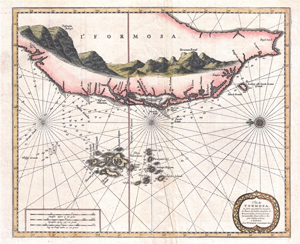
L'Île de Formosa, ou sont exactement marquez les bancs de sables, rochers et brasses d'eau, le tout fait sur les nouvelles observations des plus habiles pilotes.
1729 (undated) 12 x 14.25 in (30.48 x 36.195 cm) 1 : 380160
1729 (undated) 12 x 14.25 in (30.48 x 36.195 cm) 1 : 380160
Description
One of the few obtainable truly antique maps to focus specifically on Taiwan or Formosa, this is Pieter Van der Aa's 1729 nautical chart L'Île de Formosa. Oriented to the East, the map covers the southwestern three-fourths of the island as well the adjacent Penghu Islands, or Pescadores. Although this map dates to 1729, this map reflects Taiwan during the Dutch Colonial Period, when the island was under VOC rule, from 1624 to 1662. From 1622 the Dutch maintained a trading entrepôt on the Pescadore Islands. In 1624 they were driven from the islands by the Ming Chinese and fled to the mainland of Taiwan, where they established Fort Zeekam, or Fort Zeelandia, the Dutch base near the modern city of Tainan, here identified as Tayouan. The Dutch subsequently expanded to control much of Formosa and it became one of their most profitable East Asian factories. They developed extensive rice and sugar plantations, taking advantage of extensive imported Han labor from mainland China. In 1661 the Ming Chinese general Koxinga landed a large army at Lakjemuyse. He rallied the indigenous Taiwanese, as well as the Han workers imported from mainland China, against the Dutch, successfully driving them from the island after some 38 years of occupation. This map was printed in Leiden for Van Der Aa's 1729 Galerie Agreable du Monde.
Cartographer
Pieter van der Aa (1659 - 1733) was a Dutch publisher of maps and atlases active in the late 17th and early 18th centuries. Van der Aa was born in Leyden in 1659. At nine he was apprenticed to a local bookseller and, by 21, had established his own publishing, printing, and auctioneering house. In 1692 Van der Aa was appointed to be one of the High Commissioners of the Booksellers Guild. During his long and impressive career Van der Aa produced thousands of maps, including a vast 28 volume atlas containing no less than 3,000 maps. Few of Van der Aa's maps were original productions, most being copied from the work of earlier cartographers. Nonetheless, when one of Van der Aa's rare original pieces does appear, his style, with unusual projections, elegant engraving, and precise detail, is instantly recognizable and highly desirable. He also pioneered the cartographic idea of separating border artwork from the map plate itself such that every map in a collection could have a similar elaborate border without actually having to re-engrave the complex plates. This technique was used to great effect by later 18th century publishers like Brion de la Tour. Following Van der Aa's death in 1733, his much admired Nouvel Atlas was reissued by the Dutch firm of Covens & Mortier. Today Van der Aa's work is admired for its fine delicate engraving and unusual projections and is considered highly desirable among collectors. More by this mapmaker...
Source
Van der Aa, P., Galerie Agreable du Monde, (Leiden) 1729.
Condition
Very good. Slight wear on original fold lines. Platemark visible. Blank on verso.
References
OCLC 63835769.