This item has been sold, but you can get on the Waitlist to be notified if another example becomes available.
1962 Dolph Map of Fort Lauderdale, Florida
FortLauderdale-dolph-1962$225.00


Title
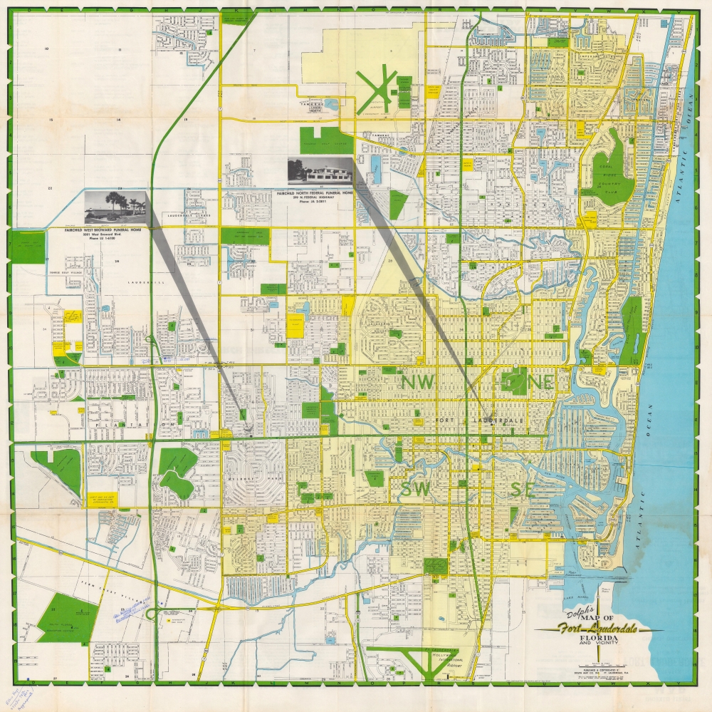
Dolph's map of Fort Lauderdale, Florida and vicinity.
1962 (undated) 30 x 30 in (76.2 x 76.2 cm) 1 : 22750
1962 (undated) 30 x 30 in (76.2 x 76.2 cm) 1 : 22750
Description
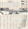
A large and colorful map of Fort Lauderdale, Florida produced c. 1962 by the Dolph Map Co., based in the same city. It depicts Fort Lauderdale in the midst of its postwar population boom, when it also became nationally renowned as a tourist destination.
A Closer Look
Schools, churches, hospitals, parks, the Florida East Coast Railway's route, and other features are indicated. Golf courses, housing developments, and proposed new construction are evident along the city's outskirts, reflecting its ongoing growth. Revealingly, this piece includes references to the Jim Crow era in the South, clearly labelling segregated schools and cemeteries (local beaches were also strictly segregated, a situation against which the active local chapter of the NAACP continuously fought). Two locations of Fairchild Funeral Homes, the map's sponsor, are prominently labelled. Light-yellow shading denotes Fort Lauderdale proper, while unshaded areas are neighboring towns and census-designated places (some of which have since been incorporated into Fort Lauderdale).Historical Context
After World War II, Fort Lauderdale (and Florida in general) experienced a massive population boom because returning soldiers trained in Florida before being sent overseas decided to settle there. With the end of the war, the decommissioning of the city's two airfields and their conversion to civilian use were a boon to the local economy. Tourism also increased dramatically during the 1940s and 1950s with the advent of affordable automobiles, plentiful jobs, and numerous highways. Fort Lauderdale became especially popular with students travelling during their spring break, a trend both reflected and reinforced by the 1960 film Where the Boys Are.Dating the Map
Several features of the map suggest a date in the early 1960s. Fort Lauderdale–Hollywood International Airport appears with its current name, instead of the earlier Broward County International Airport. The name 'Sunshine State Parkway' is used for the Florida Turnpike, yet Interstate-95 does not appear, consistent with the early 1960s. Moreover, 'Yankee Stadium' next to Executive Airport and the inclusion of the Florida Air Academy indicate a date of 1962 or later. The retention of 'colored' institutions is likely anachronistic or a reflection of local resistance to desegregation rather than a reflection of the law at the time of the map's publication.Publication History and Census
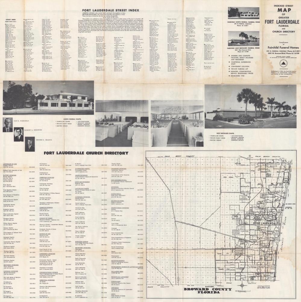
This map was produced and published by the Dolph Map Co., Inc. around the year 1962. Being based in Fort Lauderdale, Dolph naturally published maps of the city regularly (including from c. 1947 and c. 1955 previously sold by us). This appears to be a scarce variant of the map; the examples cataloged in the OCLC and at the Tampa Bay History Center's Touchton Map Library include a street index for Fort Lauderdale on the recto and a map of Pompano Beach, Deerfield Beach, Margate, Boca Raton and other nearby towns and cities on the verso. But the present example, sponsored by Fairchild Funeral Homes, places the Fort Lauderdale index on the verso along with a church directory, photos of the sponsor's funeral homes and some local churches, and a map of Broward County.Cartographer
Frank B. Dolph (October 3, 1897 - November 26, 1975) was an American businessman and map publisher. Born in Great Neck, Long Island, New York, Dolph served as a Navy storekeeper during World War I. He began selling maps in 1919 after returning from England, likely for the George F. Cram Company, where he ultimately became an administrative aide. He also worked for the Rand McNally Company for some time before he founded his own map publishing firm, Dolph and Stewart, with his friend, sometime in the 1920s. Dolph and Stewart made maps throughout the 1920s and 1930s until they sold the firm in 1945 when Dolph decided to return to Florida. Dolph opened a new map publishing business, the Frank B. Dolph Map Co. in Ft. Lauderdale and published city plans of cities throughout the United States. Many of his maps were distributed by Chambers of Commerce or sold at newsstands. Real estate developers greatly appreciated his maps, those published by both the Dolph and Stewart Company and the Frank B. Dolph Company. Dolph retired as president of his firm around 1965, when he handed the business off to his son, Frank B. Dolph, Jr. Dolph worked with cartographer Theodore M. Politano for decades while operating the Frank B. Dolph Map Company. More by this mapmaker...
Condition
Good. Light toning at top-left, soiling at bottom-right. Some handwritten annotation in ink.
References
OCLC 5415715 (variant). Tampa Bay History Center, Touchton Map Library 2019.030.014.