1707 J. B. Homann Map of France
France-homann-1702$550.00

Title
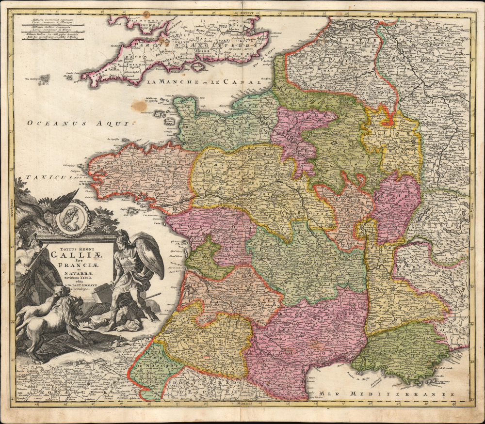
Totius Regni Galliae Sive Francia et Navarrae novissima Tabula edita a Io. Bapt. Homann. Norimbergae.
1702 (undated) 19 x 22.5 in (48.26 x 57.15 cm) 1 : 408000
1702 (undated) 19 x 22.5 in (48.26 x 57.15 cm) 1 : 408000
Description
This is a 1702/1710 Johann Baptist Homann map of France, produced at the opening of the War of the Spanish Succession (1701 - 1714). Its detail and its allegorical cartouche emphasize the might of France during the last years of the reign of Louis XIV (1638 - 1715), which coincided with the war.
A Closer Look
The map depicts the Kingdoms of France. Bordering regions of Italy, Switzerland, and Germany are detailed along the right border, and southern England appears at the top of the map. In the southwest, the Kingdom of Navarre and the frontier regions of Spain are delineated. Beyond Navarre, the coast of Spain is overshadowed by the martial cartouche flattering the French king. The map is richly detailed, illustrating fortified cities, villages, roads, bridges, forests, and castles. Topography is indicated pictorially. Note in particular the Canal Royal that connects Toulouse to the Mediterranean and was one of the great works completed during the Sun King's reign.The Cartouche
The map's allegorical title cartouche features armed and armored Ares, bearing a shield emblazoned with the fleurs-de-lis of France. He stands astride a corpse - unidentified, although the style of its coat and frilly sleeves was fashionable among Spanish nobility of the turn of the 18th century, and a very similar coat can be seen worn by King Philip V of Spain in contemporary paintings. Accompanying warriors arrayed against this French Ares represent the Holy Roman Empire, and a pair of lions represent England and the Dutch Republic. Atop this warlike cartouche is a laurel-wreathed medallion of King Louis XIV.Publication History and Census
This map was engraved as early as 1700, and appeared in Homann's first atlases published by David Funcke beginning in 1702. It was also included in Homann's 1707 Neuer Atlas, the present example being from the 1710 2nd edition of that work. Following Louis XIV's 1715 death and the end of the war, the map was heavily reworked, the present military cartouche replaced by a more reverent one alluding to the achievements of the late king. The separate map is well represented in institutional collections and dealers' catalogs, albeit frequently misdated.Cartographer
Johann Baptist Homann (March 20, 1664 - July 1, 1724) was the most prominent and prolific map publisher of the 18th century. Homann was born in Oberkammlach, a small town near Kammlach, Bavaria, Germany. As a young man, Homann studied in a Jesuit school and nursed ambitions of becoming a Dominican priest. Nonetheless, he converted to Protestantism in 1687, when he was 23. It is not clear where he mastered engraving, but we believe it may have been in Amsterdam. Homann's earliest work we have identified is about 1689, and already exhibits a high degree of mastery. Around 1691, Homann moved to Nuremberg and registered as a notary. By this time, he was already making maps, and very good ones at that. He produced a map of the environs of Nürnberg in 1691/92, which suggests he was already a master engraver. Around 1693, Homann briefly relocated to Vienna, where he lived and studied printing and copper plate engraving until 1695. Until 1702, he worked in Nuremberg in the map trade under Jacob von Sandrart (1630 - 1708) and then David Funck (1642 - 1709). Afterward, he returned to Nuremberg, where, in 1702, he founded the commercial publishing firm that would bear his name. In the next five years, Homann produced hundreds of maps and developed a distinctive style characterized by heavy, detailed engraving, elaborate allegorical cartouche work, and vivid hand color. Due to the lower cost of printing in Germany, the Homann firm could undercut the dominant French and Dutch publishing houses while matching their diversity and quality. Despite copious output, Homann did not release his first major atlas until the 33-map Neuer Atlas of 1707, followed by a 60-map edition of 1710. By 1715, Homann's rising star caught the attention of the Holy Roman Emperor Charles VI, who appointed him Imperial Cartographer. In the same year, he was also appointed a member of the Royal Academy of Sciences in Berlin. Homann's prestigious title came with several significant advantages, including access to the most up-to-date cartographic information as well as the 'Privilege'. The Privilege was a type of early copyright offered to very few by the Holy Roman Emperor. Though less sophisticated than modern copyright legislation, the Privilege offered limited protection for several years. Most all J. B. Homann maps printed between 1715 and 1730 bear the inscription 'Cum Priviligio' or some variation. Following Homann's death in 1724, the firm's map plates and management passed to his son, Johann Christoph Homann (1703 - 1730). J. C. Homann, perhaps realizing that he would not long survive his father, stipulated in his will that the company would be inherited by his two head managers, Johann Georg Ebersberger (1695 - 1760) and Johann Michael Franz (1700 - 1761), and that it would publish only under the name 'Homann Heirs'. This designation, in various forms (Homannsche Heirs, Heritiers de Homann, Lat Homannianos Herod, Homannschen Erben, etc.) appears on maps from about 1731 onwards. The firm continued to publish maps in ever-diminishing quantities until the death of its last owner, Christoph Franz Fembo (1781 - 1848). More by this mapmaker...
Source
Homann, J. B., Neuer Atlas bestehend in einig curieusen Astronomischen Kuppren und vielen auserlesenen accuratensten Land-Charten über die Gantze Welt, (Nuremberg: Homann) 1710.
Homann's Neuer Atlas bestehend in einig curieusen Astronomischen Kuppren und vielen auserlesenen accuratensten Land-Charten über die Gantze Welt was first publihsed in 1707 with 33 maps. A second edition followed in 1710 with 60 maps. Subsequent editions followed until about 1730. The title page notes proudly that the atlas features measurements based on the 'Copernican principle of the moving sky', a truly state-of-the-art innovation for the period. Regardless of editions, collations of the atlas are inconsistent, with some examples having less, while others have more maps - a consequence of the fact that the map sheets were delivered loose, to be bound at the buyer's discretion, and so some buyers chose to omit maps they did not consider relevant, or add others they did. Between editions, the constituent maps, particularly of European regions, were regularly updated to reflect the most recent political events. The atlas continued to be published by Homann's son, J. C. Homann (1703 - 1730), and then by Homann Heirs. Most examples also feature a fine allegorical frontispiece with the title Atlas Novus Terrarum Orbis Imperia, regna et Status, which was used for multiple Homann atlases, including the Neuer Atlas and the Atlas Minor.
Condition
Very good. Few spots in upper left quadrant. Verso repair to centerfold separation. Original outline and wash color.
References
OCLC 611423095. Rumsey 12499.073 (1716 state).