This item has been sold, but you can get on the Waitlist to be notified if another example becomes available, or purchase a digital scan.
1678 Sanson Map of France and her Prizes from the Thirty Years' War
France-sanson-1678$200.00

Title
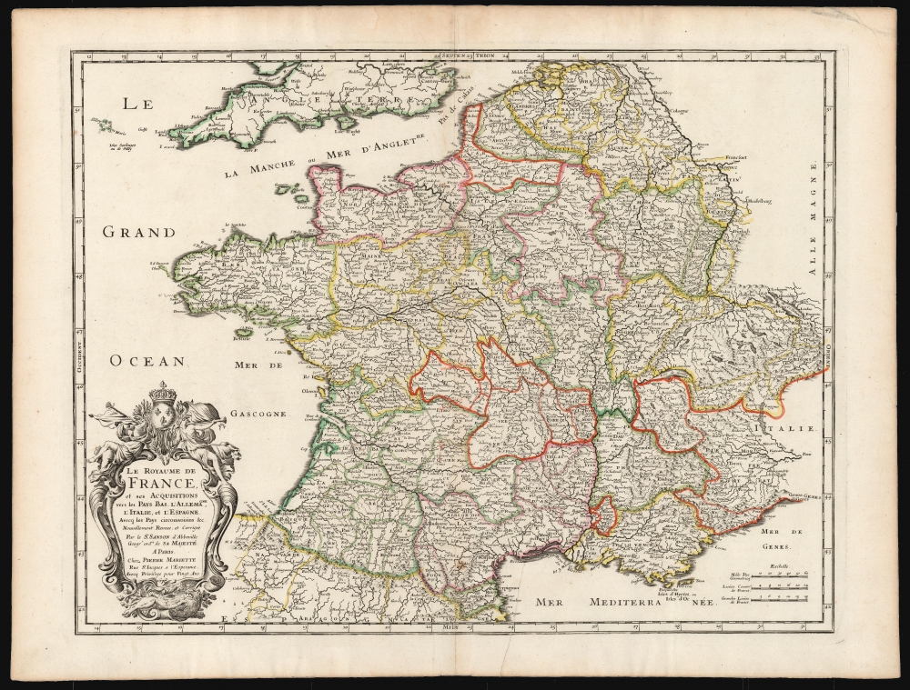
Le Royaume De France et ses Acquisitions vers les Pays Bas, L'Allemagne, L'Italie, et L'Espagne. Avec les Pays Circomvoisins etc. Nouvellement Revue, et Corrigee Par le Sr. Sanson d'Abbeville Geogr. Ordre. de sa Majesté A Paris.
1678 (dated) 15.5 x 20.5 in (39.37 x 52.07 cm) 1 : 2900000
1678 (dated) 15.5 x 20.5 in (39.37 x 52.07 cm) 1 : 2900000
Description
This is a beautiful, original-color example of Nicolas Sanson's 1678 folio map of the Kingdom of France. Sanson was the preeminent French geographer of the 17th century, and his austere, elegant aesthetic set the standard for French mapmakers into the next century - easily distinguishing the works of French mapmakers from the florid work produced at the same time in the Netherlands.
A Closer Look
Sanson's map is detailed throughout the Kingdom of France, but it was intended to focus on France's acquisitions in the Thirty Years' War (1618 - 1648). Sanson's title explicitly notes that the map includes France's acquisitions from the Netherlands, Germany, Italy, and Spain. Thus, for example, Sanson's map details France's holds on the Alsace, Artois, Monferrat in the Piedmont, and Perpignan on the Spanish Mediterranean border.A Revised Edition
The first edition of this map was printed in 1665; the present map represents almost certainly a newly engraved plate, as there are a multitude of small changes, more than would be reasonable to expect were the first plate simply reworked. It also includes geographic features not present on the 1665. In the south of France, the Cap du Sete and the Fort de Brescou are added; the place name near Toulon given as 'Sixtours' on the 1665 has here been corrected to 'Sixfours.' The placename for Lugano, lacking on the first edition, is here added. Off the coast of England, the Isles of Scilly are added. In the main, the re-engraved work is bolder and more legible than its precursor, with features such as its mountains and lakes more confidently engraved.Publication History and Census
The map was engraved in 1665 for inclusion in Sanson's Cartes générales de toutes les parties du monde, published in Paris by his collaborator Pierre Mariette. This example is a second plate of the map, printed in the 1678 edition of the same work. We are aware of 15 examples of the separate map in institutional collections, of which 6 are cataloged as this 1678 plate.CartographerS
Nicolas Sanson (December 20, 1600 - July 7, 1667) and his descendants were the most influential French cartographers of the 17th century and laid the groundwork for the Golden Age of French Cartography. Sanson was born in Picardy, but his family was of Scottish Descent. He studied with the Jesuit Fathers at Amiens. Sanson started his career as a historian where, it is said, he turned to cartography as a way to illustrate his historical studies. In the course of his research some of his fine maps came to the attention of King Louis XIII who, admiring the quality of his work, appointed Sanson Geographe Ordinaire du Roi. Sanson's duties in this coveted position included advising the king on matters of geography and compiling the royal cartographic archive. In 1644, he partnered with Pierre Mariette, an established print dealer and engraver, whose business savvy and ready capital enabled Sanson to publish an enormous quantity of maps. Sanson's corpus of some three hundred maps initiated the golden age of French mapmaking and he is considered the 'Father of French Cartography.' His work is distinguished as being the first of the 'Positivist Cartographers,' a primarily French school of cartography that valued scientific observation over historical cartographic conventions. The practice result of the is less embellishment of geographical imagery, as was common in the Dutch Golden Age maps of the 16th century, in favor of conventionalized cartographic representational modes. Sanson is most admired for his construction of the magnificent atlas Cartes Generales de Toutes les Parties du Monde. Sanson's maps of North America, Amerique Septentrionale (1650), Le Nouveau Mexique et La Floride (1656), and La Canada ou Nouvelle France (1656) are exceptionally notable for their important contributions to the cartographic perceptions of the New World. Both maps utilize the discoveries of important French missionaries and are among the first published maps to show the Great Lakes in recognizable form. Sanson was also an active proponent of the insular California theory, wherein it was speculated that California was an island rather than a peninsula. After his death, Sanson's maps were frequently republished, without updates, by his sons, Guillaume (1633 - 1703) and Adrien Sanson (1639 - 1718). Even so, Sanson's true cartographic legacy as a 'positivist geographer' was carried on by others, including Alexis-Hubert Jaillot, Guillaume De L'Isle, Gilles Robert de Vaugondy, and Pierre Duval. More by this mapmaker...
Pierre Mariette (1569 - 1657) was a French publisher and engraver active in Paris during the first half of the 19th century. Mariette established himself as successful publisher of art prints, but decided to turn his energy to cartography with the purchase of the plates for Melchior Tavernier's maps in 1644. Tavernier had partnered with Sanson before his death and Mariette followed suit. Around 1644- 1648 Mariette partnered with Nicolas Sanson, a then nascent figure in French cartography, to produce folio maps and atlases. The Sanson-Mariette relationship depended upon Sanson to draw and obtain rights for the maps while Mariette engraved them and paid for the expensive printing process. The two then shared rights to the maps into perpetuity. The finished copper plates were split between two such that neither could publish an atlas without the other's assent. The relationship seemed reasonably amicable until Mariette's death in 1657, when disputes arose between Sanson and Mariette's heirs. A court battle finally returned the most of the plates to Sanson's own heirs in 1674. As a consequence, some printings feature the Mariette imprint, others the Sanson imprint, and still others both imprints. Learn More...
Source
Sanson, N. and Mariette, P., Atlas du Monde, (Paris) 1678.
Condition
Very good. Printer's crease at bottom, else an excellent example with bright original outline color and a bold strike.
References
OCLC 1177082720.