This item has been sold, but you can get on the Waitlist to be notified if another example becomes available, or purchase a digital scan.
1851 Pease Map of French and English Grants on Lake Champlain
FrenchEnglishChamplain-pease-1851-3$150.00

Title
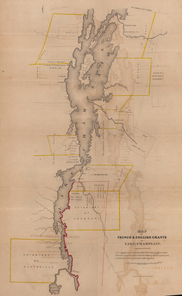
Map of French and English Grants on Lake Champlain.
1851 (undated) 22 x 13 in (55.88 x 33.02 cm) 1 : 253440
1851 (undated) 22 x 13 in (55.88 x 33.02 cm) 1 : 253440
Description
This is an 1851 Richard H. Pease map of Lake Champlain illustrating French and English land grants. These grants were key to both French and English attempts to establish control over the strategically and commercially signficant lake.
A Closer Look
French grants are illustrated in yellow and English grants in black. The Dominic Dellius Grant of 1696 is highlighted, as the northern part of the Dellius grant is outlined in red. Apart from the depiction of the grants, very little detail is included. Within Lake Champlain, both Grand Isle and Long Island are named.Comments on the Grants
While the chronology of the grants is unclear, it is apparent that, except for that of Dominic Dellius, the French grants were much larger than the English. Given the work in which this map was included, it is possible that better records were available regarding English grants, which allows for their more precise presentation.Granting Control of Lake Champlain
The Lake Champlain region, straddling what is now the border between New York and Vermont, and extending into Quebec, was a focal point of French and English colonial ambitions in North America. The French, arriving first in the early 17th century, established strategic military outposts and engaged in fur trading. They fortified Lake Champlain as far south as Crown Point, building Fort St. Frederick and Carillon (Ticonderoga). French King Louis XV established land grants, known as seigneuries, along the lake's shores. French settlers slowly moved into the region. The area became increasingly contested during the 18th century during the French and Indian War (1754 - 1763), which saw the English establish regional hegemony. Post-war, the British issued colonial grants to solidify their presence and encourage settlement, even as the region remained a hotbed of contention between New York and the New Hampshire Grants, the latter of which eventually became Vermont. The strategic value of Lake Champlain, underscored by its use in subsequent conflicts like the American Revolutionary War (1775 - 1783), highlights its importance in the colonial struggle for control and influence in North America.Publication History
This map was engraved and printed by Richard H. Pease of Albany, and included in Edmund Bailey O'Callaghan's 1851 Documentary History of the State of New York. We note perhaps a dozen examples of the separate map cataloged in OCLC.Cartographer
Richard H. Pease (1813 - 1869) was an American merchant and lithographer active in Albany, New York, during the middle part of the 19th century. Pease is best recognized for his publication of America's first Christmas card for the 1849 -1850 holiday season. He also played a role in populating the American version of Santa Claus and tying it to consumerism in the holiday advertisements his produced for his 'Temple of Fancy or Pease's Great Variety Store.' Pease operated the Great Variety Store in tandem with his lithography business until he passed the store on to his son, Harry E. Pease, in 1855. The store was located at 516 Broadway, Albany. Pease also published hand-colored lithographs of fruit for Ebenezer Emmons’s book Agriculture of New York State, published between 1846 and 1854. From 1856 to 1867 he worked with the lithography firm of Hoffman, Knickerbocker and Co. More by this mapmaker...
Source
O'Callaghan, E.B., The Documentary History of the State of New York, (Albany: Weed, Parsons, and Co.) 1851.
Condition
Good. Even overall toning. Offsetting. Verso repairs to fold separations. Close bottom margin.
References
New York Public Library Map Div. 16-5833. OCLC 78904405.