This item has been sold, but you can get on the Waitlist to be notified if another example becomes available, or purchase a digital scan.
1777 Cook Map of the Friendly Islands or Tonga
FriendlyIsles-cook-1777$125.00

Title
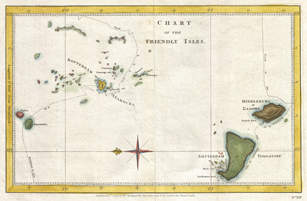
Chart of the Friendly Isles.
1777 (dated) 8.5 x 13 in (21.59 x 33.02 cm)
1777 (dated) 8.5 x 13 in (21.59 x 33.02 cm)
Description
A highly uncommon chart of the Friendly Islands, or Tonga, from 1777. Oriented to the East, this map depicts the Tongatapu Island Group and the Ha'Apai Group that make up the Kingdom of Tonga. Shows the routes of the Resolution and the Adventure on Captain Cook's second voyage, 1772-1774. Cook's second voyage was intended to discover the apocryphal Terra Australis a theoretical southern continent that is not to be confused with Australia or Antarctica. On this voyage Cook crossed the Antarctic Circle and nearly, but not quite, spotted the Antarctic mainland. He landed at the Friendly Islands and laid on this map on the return portion of his voyage in 1773 and 1774. Published in 1777 by Thomas Cadell of London.
Cartographer
Captain James Cook (7 November 1728 - 14 February 1779) is a seminal figure in the history of cartography for which we can offer only a cursory treatment here. Cook began sailing as a teenager in the British Merchant Navy before joining the Royal Navy in 1755. He was posted in America for a time where he worked Samuel Holland, William Bligh, and others in the mapping of the St. Lawrence River and Newfoundland. In 1766 Cook was commissioned to explore the Pacific and given a Captaincy with command of the Endeavour. What followed were three historic voyages of discovery, the highlights of which include the first European contact with eastern Australia, the discovery of the Hawaiian Islands (among many other Polynesian groups), the first circumnavigation of New Zealand, some of the first sightings of Antarctica, the first accurate mapping of the Pacific Northwest, and ultimately his own untimely death at the hands of angry Hawaiians in 1779. The influence of Cook work on the mapping and exploration of the Pacific cannot be understated. More by this mapmaker...
Source
Cook, James, A Voyage towards the South Pole, and Tound the World. Performed in His Majesty's ships the Resolution and Adventure, in the years 1772, 1773, 1774, and 1775, 2nd edition, London: Printed for W. Strahan; and T. Cadell in the Strand, 1777.
Condition
Very good condition. Original centerfold. Blank on verso.
References
Rumsey 3404.018. David, A., The Charts and Coastal Views of Captain Cook's Voyages, 2.111A. National Library of Australia, Map Collection, Rex Nan Kivell Collection Map NK 2456/54.