1790 Liesganig Massive Case Map of Galicia (Poland / Ukraine)
Galicia-liesganig-1790$6,500.00


Title
Regna Galicia, et Lodomeriae Josephi II et M. Theresiae Augg. iussu methodo astronomico-trigonometrica, nec non Bukovina geometrice dimensa...
1790 (dated) 65.5 x 87 in (166.37 x 220.98 cm) 1 : 288000
1790 (dated) 65.5 x 87 in (166.37 x 220.98 cm) 1 : 288000
Description
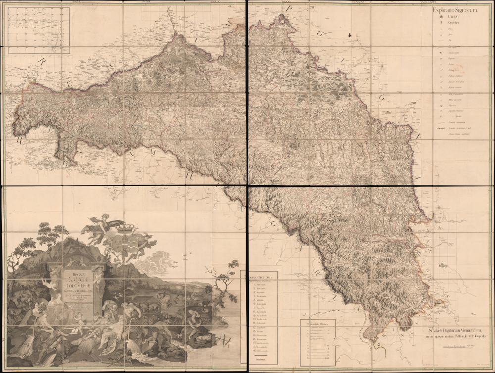
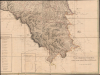
This is the 1790 first edition of Joseph Liesganig's seminal and massive map of Galicia, a territory roughly conforming to the modern border between Poland and Ukraine. The region, which had been granted to the Habsburgs in the First Partition of Poland, was virtually unmapped using modern methods before Liesganig and his team spent months preparing the present work, making it one of the most important maps of Eastern Europe of the era.
The name Galicia is derived from the Medieval town of Halych (here as Halicz, towards the bottom-center of the top-right quadrant). Lodomeria is the Latin name for Volhynia, which comes from the city of Volodymyr (here as Włodzimirz, ironically just beyond the borders of the kingdom), which itself is named for Vladimir (Volodymyr) the Great, who was born near there in the 10th century.
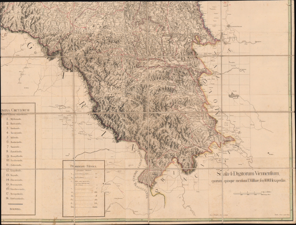
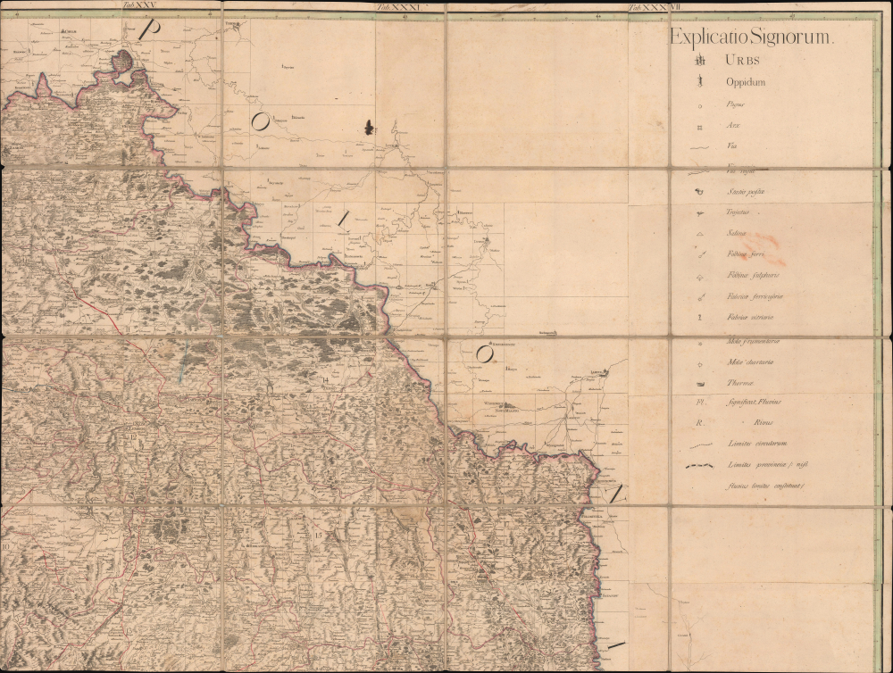
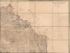
The map provides granular detail on the Kingdom of Galicia and Lodomeria, noting cities, towns, villages, fortifications, roads (including the 'Via regia'), post offices, river crossings, mines, glassworks, mills, hot springs, terrain, waterways, mountains, and administrative divisions, as explained in a Latin legend at the top-right. A key map at the top-left depicts forty-two individual panels (which do not perfectly align with the sixty-four dissected sheets). It presents a simple breakdown of the kingdom's eighteen 'circles' (circulorum / kreise, similar to a district or county). These are listed at the bottom along with a scale and a Polish pronunciation guide. The use of Polish placenames is indicative of the region's recent acquisition from Poland and its long history in the orbit of the Polish-Lithuanian Commonwealth.
Both on the map and in the list of 'circles,' Bukovina is recorded separately. At the border of the Habsburg (Austrian), Ottoman, and Russian Empires, the region's boundaries were negotiated following the establishment of the Kingdom of Galicia and Lodomeria. The Austrians occupied the area in 1774, arguing that a necessary road linking the new Galician territory to Transylvania (also under Habsburg rule) ran through Bukovina. Initially ruled as a separate military district centered on Czernowitz, following a 1786 visit by Emperor Joseph II to Lviv, it was decided to annex Bukovina to Galicia-Lodomeria. However, it remained a distinct district, separate from the eighteen 'circles.'
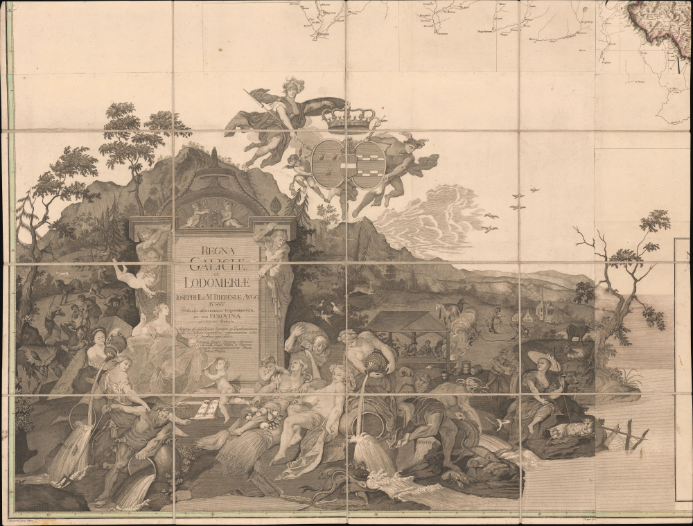
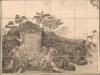
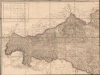
The large and elaborate cartouche that takes up nearly the entire bottom-left quadrant depicts the personifications of the rivers Vistula, Dunajec, San, Seret, Prut, Cheremosh, Stryi, and Dniester. Also visible are figures of animals, surveyors at work, laborers, and carpenters. In the upper part, the deities Minerva and Mercury lift an ornamental cartouche with the coats of arms of Galicia and Lodomeria under the imperial crown. In the background is a mountain landscape, suggestive of the Carpathian Mountains, which divide Galicia from Slovakia, Hungary, and Transylvania.
Soon after the partition, Vienna determined to produce a political map of the region made by civilian cartographers (led by Liesganig), concurrent with a military map of the region prepared by military cartographers (the Quartermaster General's Staff). Initially, these two groups worked closely, and some military cartographers were part of Liesganig's team, but he was allowed to operate independently of the military hierarchy.
Liesganig's two most important assistants were, like him, Jesuits: Franz Güssman (1741 - 1806) and Ignaz Rain (who also worked as an assistant to Hungarian Jesuit astronomer Maximilian Hell). Ludwik Hoszowski and Jastrzębowski, also aided Lisganig's surveying work, as did a troublesome enfant terrible, Franz Xaver von Zach (1754 - 1832), who later published widely in astronomy while also castigating Hell and Liesganig. Astronomical observations for the map were conducted from the observatory of the Jesuit college in Lviv, the tower of the Lubomirski Palace in Rzeszów, and the Kościuszko Mound (then known as Wzgórze Błogosławionej Bronisławy) near Kraków.
Meanwhile, Ruthenians in the eastern part of Galicia chafed at both Habsburg rule and the increasingly prominent Polish nationalist movement, which recalled earlier Polonization policies while under Polish-Lithuanian rule. While the term Ruthenian was historically vague (and, unhelpfully, an exonym to the people themselves), it came to refer to Russian, Ukrainian, and Belarusian speakers of the Austrian (later Austro-Hungarian) Empire. As the 19th century progressed, these Ruthenians tended to divide into pro-Russian and pro-Ukrainian camps. By the end of the 19th century, most of these people began to identify as Ukrainian. The complex ethno-linguistic landscape of Galicia led to the area becoming a site of continual and horrific violence after the collapse of the Austro-Hungarian and Russian Empires in 1917 - 1918, violence which continued into and straight through World War II.
Catalog listings variously date the map to 1790 or 1794, suggesting two printings (they also vary on the number of sheets between 42, 49, and 64; several institutions appear to lack the bottom-left quadrant with the title cartouche). In any event, the map is held by Yale University, the Library of Congress, the University of Wisconsin - Milwaukee, the University of Alberta, the University of London, the British Library, the National Archives in Kew, and roughly twelve institutions in Continental Europe. A second edition was produced in 1824, tracing territorial changes brought about by the Napoleonic Wars and the Congress of Vienna.
A Closer Look
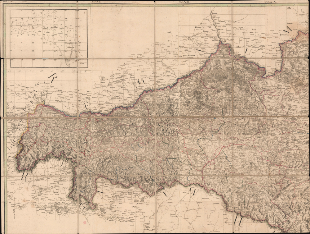
This map consists of 64 panels, mounted on linen into 4 sections, which combined measure more than 5 x 7 feet. Coverage spans the modern border of Poland and Ukraine, while the region at the top around Chełm is very close to the modern border of both countries with Belarus. It covers Habsburg-ruled Galicia (the Kingdom of Galicia and Lodomeria) from Oświęcim and Bielsko-Biała in the west to Chernivtsi (Czernowitz) in the east, with portions of surrounding territories also depicted. Lviv (Lemberg / Lwow), the cultural and administrative center of the region, was located near its geographic center, at the left-center of the upper-right quadrant here.The name Galicia is derived from the Medieval town of Halych (here as Halicz, towards the bottom-center of the top-right quadrant). Lodomeria is the Latin name for Volhynia, which comes from the city of Volodymyr (here as Włodzimirz, ironically just beyond the borders of the kingdom), which itself is named for Vladimir (Volodymyr) the Great, who was born near there in the 10th century.
The map provides granular detail on the Kingdom of Galicia and Lodomeria, noting cities, towns, villages, fortifications, roads (including the 'Via regia'), post offices, river crossings, mines, glassworks, mills, hot springs, terrain, waterways, mountains, and administrative divisions, as explained in a Latin legend at the top-right. A key map at the top-left depicts forty-two individual panels (which do not perfectly align with the sixty-four dissected sheets). It presents a simple breakdown of the kingdom's eighteen 'circles' (circulorum / kreise, similar to a district or county). These are listed at the bottom along with a scale and a Polish pronunciation guide. The use of Polish placenames is indicative of the region's recent acquisition from Poland and its long history in the orbit of the Polish-Lithuanian Commonwealth.
Both on the map and in the list of 'circles,' Bukovina is recorded separately. At the border of the Habsburg (Austrian), Ottoman, and Russian Empires, the region's boundaries were negotiated following the establishment of the Kingdom of Galicia and Lodomeria. The Austrians occupied the area in 1774, arguing that a necessary road linking the new Galician territory to Transylvania (also under Habsburg rule) ran through Bukovina. Initially ruled as a separate military district centered on Czernowitz, following a 1786 visit by Emperor Joseph II to Lviv, it was decided to annex Bukovina to Galicia-Lodomeria. However, it remained a distinct district, separate from the eighteen 'circles.'
The large and elaborate cartouche that takes up nearly the entire bottom-left quadrant depicts the personifications of the rivers Vistula, Dunajec, San, Seret, Prut, Cheremosh, Stryi, and Dniester. Also visible are figures of animals, surveyors at work, laborers, and carpenters. In the upper part, the deities Minerva and Mercury lift an ornamental cartouche with the coats of arms of Galicia and Lodomeria under the imperial crown. In the background is a mountain landscape, suggestive of the Carpathian Mountains, which divide Galicia from Slovakia, Hungary, and Transylvania.
Making the Map
The preparation of this map took several years, including 18 months of surveying and taking astronomical-trigonometrical measurements. It was the earliest detailed, modern map of the lands seized by Austria from Poland in the First Partition in 1772. It can also be seen as the first large-scale triangulation carried out in Polish (that is, largely or primarily Polish-speaking) lands.Soon after the partition, Vienna determined to produce a political map of the region made by civilian cartographers (led by Liesganig), concurrent with a military map of the region prepared by military cartographers (the Quartermaster General's Staff). Initially, these two groups worked closely, and some military cartographers were part of Liesganig's team, but he was allowed to operate independently of the military hierarchy.
Liesganig's two most important assistants were, like him, Jesuits: Franz Güssman (1741 - 1806) and Ignaz Rain (who also worked as an assistant to Hungarian Jesuit astronomer Maximilian Hell). Ludwik Hoszowski and Jastrzębowski, also aided Lisganig's surveying work, as did a troublesome enfant terrible, Franz Xaver von Zach (1754 - 1832), who later published widely in astronomy while also castigating Hell and Liesganig. Astronomical observations for the map were conducted from the observatory of the Jesuit college in Lviv, the tower of the Lubomirski Palace in Rzeszów, and the Kościuszko Mound (then known as Wzgórze Błogosławionej Bronisławy) near Kraków.
Historical Background and Subsequent Developments
In 1772, parts of Lesser Poland, Podolia, Ruthenia, and the Carpathian Foothills, which had previously belonged to Poland-Lithuania passed to the Austrian House of Habsburg as part of the First Partition of Poland. The new 'Kingdom of Galicia and Lodomeria' (also known as 'Austrian Galicia' and unofficially as 'Austrian Poland') went through several territorial changes in the tumult of the following years, including the Third Partition of Poland and the Napoleonic Wars. The Third Partition of Poland in 1795 added more heavily Polish territory ('West Galicia') and, after the failed Polish Revolution of 1830, even more Poles arrived in Galicia and continued to pursue their revolutionary aspirations, including a failed 1846 revolt against the Austrians.Meanwhile, Ruthenians in the eastern part of Galicia chafed at both Habsburg rule and the increasingly prominent Polish nationalist movement, which recalled earlier Polonization policies while under Polish-Lithuanian rule. While the term Ruthenian was historically vague (and, unhelpfully, an exonym to the people themselves), it came to refer to Russian, Ukrainian, and Belarusian speakers of the Austrian (later Austro-Hungarian) Empire. As the 19th century progressed, these Ruthenians tended to divide into pro-Russian and pro-Ukrainian camps. By the end of the 19th century, most of these people began to identify as Ukrainian. The complex ethno-linguistic landscape of Galicia led to the area becoming a site of continual and horrific violence after the collapse of the Austro-Hungarian and Russian Empires in 1917 - 1918, violence which continued into and straight through World War II.
Publication History and Census
This map was prepared by a team of surveyors led by astronomer Joseph Liesganig. It was engraved by Gottfried Prixner, and the intricate cartouche was originally painted by Franz Anton Maulbertsch. Johann von Liechtenstern (perhaps a relation of cartographer Joseph von Liechtenstern) 'elaborated and described' the map. The subtitle indicates that a separate index of placenames was printed in addition to the map.Catalog listings variously date the map to 1790 or 1794, suggesting two printings (they also vary on the number of sheets between 42, 49, and 64; several institutions appear to lack the bottom-left quadrant with the title cartouche). In any event, the map is held by Yale University, the Library of Congress, the University of Wisconsin - Milwaukee, the University of Alberta, the University of London, the British Library, the National Archives in Kew, and roughly twelve institutions in Continental Europe. A second edition was produced in 1824, tracing territorial changes brought about by the Napoleonic Wars and the Congress of Vienna.
CartographerS
Joseph Xaver Liesganig (February 13, 1719 - March 4, 1799) was an Austrian Jesuit astronomer, mathematician, and surveyor. He was born in Graz, where his father was Hofmeister, giving him an entrée into the elite circles of the Habsburg empire. Liesganig studied at the Jesuit College in Vienna, graduating in 1734, and later became both a professor of mathematics at the University of Graz and an ordained Jesuit. The rest of his life was dedicated to the study of astronomy and related subjects. In 1752, he became a professor at the University of Vienna and an assistant at the important Jesuit observatory at his alma mater, the Jesuit College in Vienna. In 1756, he succeeded Maximilian Hell (1720 - 1792) as director of the observatory; Liesganig and Hell had many similarities, including being Jesuits, and the two became the most prominent astronomers of their age in the Habsburg realms. Among the important achievements during his tenure at the observatory in Vienna was the 1761 Transit of Venus, which led to several important discoveries, including the measurement of the distance between the Earth and the Sun. Much of Liesganig's research was dedicated to determining the exact size and shape of the Earth, a particular interest of Empress Maria Theresa. After years of geodetic measurements and astronomical observations, he published his findings in 1770 in Dimensio graduum meridiani Viennensis et Hungarici. After the First Partition of Poland in 1772, Liesganig led a team to map the new lands annexed by the Habsburgs (the 'Kingdom of Galicia and Lodomeria'), after which he became head of a new astronomical observatory in Lviv, which he headed until his death, even following the suppression of the Jesuits. He is credited with introducing the science of triangulation to Habsburg Austria. More by this mapmaker...
Gottfried Prixner (1746 - October 19, 1819) was an Austrian copperplate engraver and draughtsman. A product of the Habsburg realms in Central and Eastern Europe, he worked at various points in Vienna, Lviv, Pressburg (Bratislava), and Pest. He engraved a wide range of works, especially portraits, building and city views, and maps, including Joseph Liesganig's 'Regna Galicia, et Lodomeriae' and Janos Lipszky's 'Mappa Generalis Regni Hungariae' (1808). Learn More...
Franz Anton Maulbertsch (June 7, 1724 - August 8, 1796) was a German-Austrian painter, artist, and engraver. He was born in Langenargen near the Bodensee in Baden-Württemberg to a father (Anton Maulbertsch) who was also a painter. The younger Maulbertsch studied at the Akademie der bildenden Künste in Vienna, where he studied with Jacob van Schuppen (1670 - 1751), among others. He won first prize in the Academy's painting competition and was set for a very promising career, but was denied a professorship at his alma mater for having an 'overly bold spirit.' Maulbertsch nevertheless excelled, particularly with large paintings and frescoes, which he painted primarily in churches throughout the Habsburg lands, particularly Hungary. Along with Martin Johann Schmidt (1718 - 1801), Maulbertsch is considered the paragon of Austrian late Baroque or Rococo painting. Nevertheless, Maulbertsch's 'overly bold spirit' led him to buck conventions and experiment with different styles; on the one hand, he tended towards Neoclassicism later in life, but on the other, he has been seen as a precursor to Impressionism and Modernism, movements that appeared decades after his death. Learn More...
Condition
Very good. Dissected and mounted on linen in 4 sections with 16 panels each. Slight soiling and dampstaining.
References
OCLC 556368026, 5450143. LCCN 75694251. Olszewicz, B., Polska kartografja wojskowa (Zarys historyczny) (Warsaw: Główna Księgarnia Wojskowa) 1921, pp. 54 - 57 et passim. Aspaas, P. and Kontler, L., Maximilian Hell (1720–92) and the Ends of Jesuit Science in Enlightenment Europe, (Leiden: Brill) 2020. Dörflinger, J., Österreichische Karten des 18. Jahrhunderts, (Wien : Verlag der Akademie) 1984, pp. 61, 151. Edney, M. and Pedley, S., The History of Cartography, Volume 4: Cartography in the European Enlightenment, (Chicago: The University of Chicago Press) 2019, pp. 732 - 734.