Digital Image: 1794 Laurie and Whittle Nautical Chart or Map of the Gaspar Strait, Indonesia
Gaspar-lauriewhittle-1794_d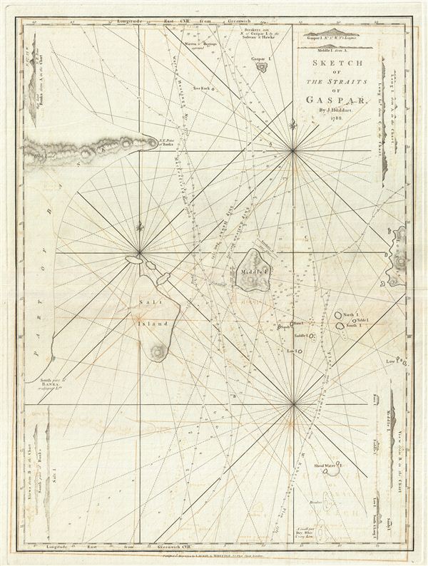

Title
Sketch of the Straits of Gaspar.
1794 (dated) 26 x 20 in (66.04 x 50.8 cm) 1 : 1930000
1794 (dated) 26 x 20 in (66.04 x 50.8 cm) 1 : 1930000
Description
FOR THE ORIGINAL ANTIQUE MAP, WITH HISTORICAL ANALYSIS, CLICK HERE.
Digital Map Information
Geographicus maintains an archive of high-resolution rare map scans. We scan our maps at 300 DPI or higher, with newer images being 600 DPI, (either TIFF or JPEG, depending on when the scan was done) which is most cases in suitable for enlargement and printing.
Delivery
Once you purchase our digital scan service, you will receive a download link via email - usually within seconds. Digital orders are delivered as ZIP files, an industry standard file compression protocol that any computer should be able to unpack. Some of our files are very large, and can take some time to download. Most files are saved into your computer's 'Downloads' folder. All delivery is electronic. No physical product is shipped.
Credit and Scope of Use
You can use your digial image any way you want! Our digital images are unrestricted by copyright and can be used, modified, and published freely. The textual description that accompanies the original antique map is not included in the sale of digital images and remains protected by copyright. That said, we put significant care and effort into scanning and editing these maps, and we’d appreciate a credit when possible. Should you wish to credit us, please use the following credit line:
Courtesy of Geographicus Rare Antique Maps (https://www.geographicus.com).
How Large Can I Print?
In general, at 300 DPI, you should at least be able to double the size of the actual image, more so with our 600 DPI images. So, if the original was 10 x 12 inches, you can print at 20 x 24 inches, without quality loss. If your display requirements can accommodate some loss in image quality, you can make it even larger. That being said, no quality of scan will allow you to blow up at 10 x 12 inch map to wall size without significant quality loss. For more information, it is best consult a printer or reprographics specialist.
Refunds
If the high resolution image you ordered is unavailable, we will fully refund your purchase. Otherwise, digital images scans are a service, not a tangible product, and cannot be returned or refunded once the download link is used.
Cartographer S
Laurie and Whittle (fl. 1794 - 1858) were London, England, based map and atlas publishers active in the late 18th and early 19th century. Generally considered to be the successors to the Robert Sayer firm, Laurie and Whittle was founded by Robert Laurie (c. 1755 - 1836) and James Whittle (1757-1818). Robert Laurie was a skilled mezzotint engraver and is known to have worked with Robert Sayer on numerous projects. James Whittle was a well-known London socialite and print seller whose Fleet Street shop was a popular haunt for intellectual luminaries. The partnership began taking over the general management of Sayer's firm around 1787; however, they did not alter the Sayer imprint until after Sayer's death in 1794. Apparently Laurie did most of the work in managing the firm and hence his name appeared first in the "Laurie and Whittle" imprint. Together Laurie and Whittle published numerous maps and atlases, often bringing in other important cartographers of the day, including Kitchin, Faden, Jefferys and others to update and modify their existing Sayer plates. Robert Laurie retired in 1812, leaving the day to day management of the firm to his son, Richard Holmes Laurie (1777 - 1858). Under R. H. Laurie and James Whittle, the firm renamed itself "Whittle and Laurie". Whittle himself died six years later in 1818, and thereafter the firm continued under the imprint of "R. H. Laurie". After R. H. Laurie's death the publishing house and its printing stock came under control of Alexander George Findlay, who had long been associated with Laurie and Whittle. Since, Laurie and Whittle has passed through numerous permeations, with part of the firm still extant as an English publisher of maritime or nautical charts, 'Imray, Laurie, Norie and Wilson Ltd.' The firm remains the oldest surviving chart publisher in Europe. More by this mapmaker...
Joseph Huddart (January 11, 1741 - August 19, 1816) was a prominent English sea captain, hydrographer, chartmaker, inventor, and entrepreneur. Born into a fishing family in Allonby, near Maryport in Cumberland, he began his career at sea with his father as a fisherman. By 1762, he commanded the sloop Allonby, carrying cured fish to Ireland for the West Indian market. Later, he designed and built the first ship he would own privately, the Patience, launched in 1768 for the West Indies trade. In 1773, Huddart entered the service of the East India Company as Fourth Officer aboard the York, sailing to St. Helena and Bencoolen. During this voyage, he carried out extensive scientific surveys and observations along the western coast of Sumatra. His efforts came to public notice in 1777 when Robert Sayer published Huddart's charts of the Sumatran coastline and commissioned him to survey St. George's Channel, a project completed in the summer of 1778. The resulting chart, noted for its precision, secured his reputation as one of Britain's foremost hydrographers and ensured his financial success. Later, in 1777, he returned to the East India Company, where he rose to the position of Captain of the Royal Admiral. For nearly ten years, he sailed routes between India and China. In 1786, his chart of the Tigris (Pearl River, China) delta was issued by Robert Sayer. Huddart retired from active service in 1791 but continued to play a central role in maritime affairs. That same year, he was elected a Fellow of the Royal Society, and in 1798, he became one of the founding directors of the East India Dock Company, laying its first foundation stone in 1804. He also served for 25 years as one of the Elder Brethren of Trinity House, offering his expertise on harbor and dock improvements. His inventive work included the three-arm protractor used by hydrographers and a system for using high-water marks in the London docks - a method that remained in practice until the 1960s. Perhaps his most significant contribution to the maritime arts was the development of steam-powered machinery for rope-making, which he transformed into a highly profitable enterprise. Learn More...