This item has been sold, but you can get on the Waitlist to be notified if another example becomes available, or purchase a digital scan.
1608 Ortelius / Vrients Map of the Republic of Genoa, Italy
Genoa-vrients-1608$2,000.00

Title
Serenissimae Reipublicae Genuensis Ducatus Et Dominii Nova Descriptio.
1608 (dated) 15.5 x 21 in (39.37 x 53.34 cm) 1 : 750000
1608 (dated) 15.5 x 21 in (39.37 x 53.34 cm) 1 : 750000
Description
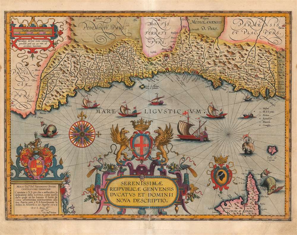
This is a beautiful example of Jan Baptista Vrients' map of the Republic of Genoa, added to Ortelius' Theatrum Orbis Terrarum in 1608. It is among the scarcest of the maps appearing in the Ortelius opus, having appeared in only the four final editions of the work. Typical of the maps thus included by Vrients, it is a tour de force of decorative cartography and stands among the most sumptuously engraved of the maps to appear in Ortelius' opus. Also, Ortelius atlases printed by Vrients enjoyed hand coloring of a very high quality, and the present map exemplifies this: the coloration on the cartouches, compass roses and ships is particularly rich.
Sivori's dedication, indeed, is superb, a plinth surmounted with the family arms, and surrounded with strapwork and vividly colored leaves. The dedicatory plinth features a mermaid crowned with clams and crab legs. The center is dominated with a bold title cartouche, surmounted with the Genoese arms and two gryphons.
In addition to the Ligurian coast, the northern part of the island of Corsica is included in the lower right. It is accompanied with the 'Moor's head' of the Corsican arms.
The sea is engraved with a stippled pattern, rhumb lines and a superb compass rose. The Ligurian sea is sailed by six grand Genoese galleys, and two other sailing ships. Two sea monsters prowl the coasts of Nizza and Corsica.
The Cartographic Lineage
Ortelius is well known as a compiler - most of the maps in his Theatrum were carefully sourced from the best sources available to him, and cited. Vrients provides a long list of authors for readers desiring 'a broad description of the cities, lands, places, enterprises and wars of the Genoese' but Vrients' direct source for the present map is not provided. According to Peter Meurer, the map is a compilation of Giovanni Antonio Magini's 1597 maps of east and west Liguria. These would be his extremely rare, separately issued first edition maps 'Liguria Overo Riviera di Genova Occidentale' and 'Liguria overo Riviera di Genova di Levante.' Vrients did not copy them wholesale. The coastline presented is significantly less concave than is indicated (accurately) on Magini's maps. Vrients appears to have wished the map to be more visually consistent with Ortelius' map of the Piedmont, which conformed to the authoritative Gastaldi maps of the mid-16th century. The specific details along the Ortelius/Gastaldi coastline such as bays, rivers and promontories have been replaced with detail from Magini's 1597 works.Dedicated to a Scion of Spain's Financial Powerhouse
The map reflects a period of great financial and political power for the Republic of Genoa. Over the course of the 16th century, many aristocratic Genoese families amassed tremendous fortunes via banking and trade, including chattel slavery, much of which was connected to the exploration and exploitation of the New World. The Spanish Empire, in particular, relied on Genoese financiers in the second half of the 16th century and the first quarter of the 17th. Genoese merchant nobility consequently became patrons of the arts - an example of this might be the dedicatee of the present map, 'Sigr. Antonioto Sivori,' (a 'Genoese Gentleman' whose name appears to have survived nowhere in the historical record but in this dedication.)Sivori's dedication, indeed, is superb, a plinth surmounted with the family arms, and surrounded with strapwork and vividly colored leaves. The dedicatory plinth features a mermaid crowned with clams and crab legs. The center is dominated with a bold title cartouche, surmounted with the Genoese arms and two gryphons.
In addition to the Ligurian coast, the northern part of the island of Corsica is included in the lower right. It is accompanied with the 'Moor's head' of the Corsican arms.
The sea is engraved with a stippled pattern, rhumb lines and a superb compass rose. The Ligurian sea is sailed by six grand Genoese galleys, and two other sailing ships. Two sea monsters prowl the coasts of Nizza and Corsica.
Publication History and Census
This map was engraved in 1608, either by or on behalf of Jan Baptista Vrients for inclusion in Ortelius' Theatrum, which Vrients continued to publish as Ortelius' executor. Thus, it only appeared in the final four editions of the Ortelius atlas, and is consequently one of the scarcest of the maps appearing in that work. Van den Broecke estimates only 925 to have been printed. Ten separate examples are cataloged in OCLC. This specific example corresponds typographically with the 1608 Italian edition of the Theatrum.CartographerS
Johannes Baptista Vrients (1552 - 1612) was a Flemish engraver, publisher, and mapseller. Little is known of his early years, but it is to be assumed he came up as an apprentice among the mapmakers of Antwerp, where the guild named him a master in 1575. In the 1590s, he executed world maps for Plancius and Linschoten. (In 1600, after Ortelius died, he became the estate's executor and acquired the plates for the Theatrum.) He would go on to publish further editions of the Ortelius atlas between 1606 and 1612. Vrients also acquired the plates for Gerard De Jode's (1516/17 - 1591) Speculum in and around 1600, but he did not republish that work - though he would preserve the De Jode plates depicting the Electors of the Holy Roman Empire, reprinting it in his editions of the Ortelius atlas after 1603. Most likely, his purchase of the De Jode plates was a play to keep them off the market. Vrients' editions of the Theatrum were not published in Antwerp (that city having fallen during the Dutch war with Spain) but in Amsterdam. More by this mapmaker...
Abraham Ortelius (April 14, 1527 - June 28, 1598) also known as Ortels, was a cartographer, geographer, and cosmographer of Brabant, active in Antwerp. He was the creator of the first modern atlas, Theatrum Orbis Terrarum and is a seminal figure in the history of cartography. Along with Gerard Mercator and Gemma Frisius, he was a founder of the Netherlandish school of cartography. His connections with Spain - culminating in his 1575 appointment as Royal Cartographer to King Phillip II of Spain - gave him unmatched access to Spanish geographical knowledge during a crucial period of the Age of Discovery. Ortelius was born in 1527 in Antwerp. In 1547 he entered the Antwerp Guild of Saint Luke as an illuminator of maps. He began trading in books, prints, and maps, traveling regularly to the Frankfurt book and print fair, where in 1554 he met Mercator. He accompanied Mercator on journeys throughout France in 1560 and it was at this time, under Mercator's influence, that he appears to have chosen his career as a scientific geographer. His first published geographic work appeared in 1564, an eight-sheet cordiform world map. A handful of other maps preceded the 1570 publication of the first edition of the Theatrum Orbis Terrarum, which would prove to be his life work. Appearing with but 53 maps in its first edition, Ortelius' work expanded with new maps added regularly. By 1592, it had 134 maps. Many of Ortelius' maps remained the standard for nearly a century. He traveled extensively, but his genius was as a compiler, locating the best informed maps on which to base his own. His contacts throughout Europe and extending even (via the Portuguese) to the Far East were formidable. Moreover, many of his maps were based on his own scholarship, particularly his historical works. His theories of geography were particularly ahead of his time with respect to the notion of continental drift, the possibility of which he mused on as early as 1596, and which would be proven correct centuries later.
In a sense his greatest achievement was his successful navigation of the religious and political violence endemic to his city throughout his adult life: The Dutch Revolt, or Eighty Years' War (1568 - 1648), fully embroiled Antwerp. Although outwardly and officially recognized as Catholic (Arias Montanus vouched for Ortelius' Catholic orthodoxy prior to his appointment as Royal Geographer), Ortelius was able to separate himself from the religious furor which characterized the war in the low countries. Ortelius showed a glimpse of himself in a letter to a friend, regarding humanist Justus Lipsius: 'I do not know whether he is an adherent of the Pope or a Calvinist, but if he has ears to hear, he will neither be one nor the other, for sins are committed on both sides'. Ortelius' own explorations of Biblical history in his maps, and the Christogram contained in his own motto, suggest him to be a religious man, but his abjuration of political religious authorities mark him as an individualist. His tombstone at St Michael's Præmonstratensian Abbey in Antwerp bears the inscription, Quietis cultor sine lite, uxore, prole. ('served quietly, without accusation, wife, and offspring.') Learn More...
Giovanni Antonio Magini (June 13, 1555 - February 11, 1617) was an Italian astronomer, astrologer, cartographer, and mathematician. Born in Padua, he completed his studies in philosophy in Bologna in 1579. In 1588 he was chosen over Galileo Galilei as the chair of mathematics at the University of Bologna after the death of Egnatio Danti. Magini was a prolific writer, putting forth theories of celestial motion (he was a supporter of a geocentric solar system), the use of quadrants in surveying and astronomy, and trigonometry. In 1608, Magini produced the first map of Italy to improve on that of Gastaldi: his meticulously researched and beautifully engraved 8-sheet Italia Nuova was hugely influential: upon its publication, Blaeu promptly copied it to produce his own wall map of Italy; the rest of the mapmaking establishment swiftly followed suit. Consequently, virtually every 17th century map of Italy can be identified as a derivative of Magini's monumental achievement. His atlas, Atlante geografico d’Italia, was published posthumously by his son in 1620. This work was intended to include maps of every Italian region with exact nomenclature and historical notes. He also served as court astrologer for the Duke of Mantua. Learn More...
Condition
Very good. Old mend to lower centerfold with no loss, but some separation. Few marginal mends away from printed image. Superb original color.
References
OCLC 557504969. Rumsey 10001.233. van den Broecke, M. Ortelius Atlas Maps: An illustrated Guide (second edition) 126.