This item has been sold, but you can get on the Waitlist to be notified if another example becomes available, or purchase a digital scan.
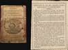
1806 Paris Geography and Astronomy Card Game (42 Cards) - With the Rules!
GeographyCards-paris-1806-2$1,750.00

Title
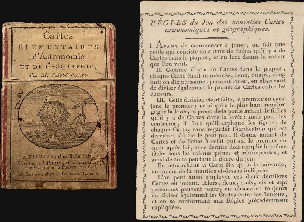
Cartes Elementaires d'Astronomie et de Géographie.
1806 (undated) 4 x 2.5 in (10.16 x 6.35 cm)
1806 (undated) 4 x 2.5 in (10.16 x 6.35 cm)
Description
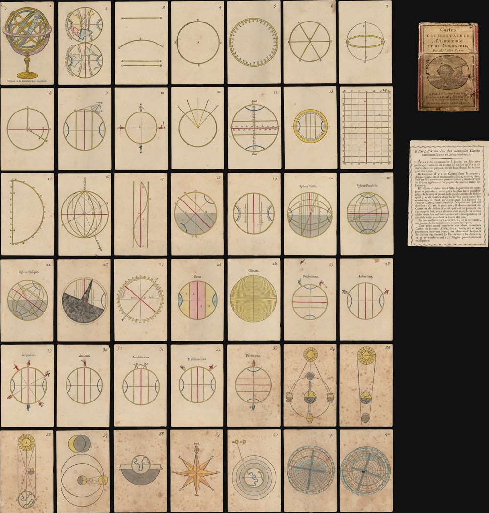
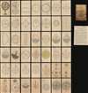
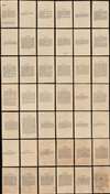
This is an extremely rare complete set of French c. 1807 hand-colored woodcut playing cards prepared as an introductory course on geography and astronomy - possibly the only surviving fully complete set. The forty-two cards feature a compass rose, an armillary sphere, maps, three volvelles, and more. On the verso of each is explanatory text.
The cards are the work of Louis-Michel Pâris, a French cleric and teacher active in Normandy. He published them as a teaching aid for his secondary school in Argentan. Although the card set is not dated, it was probably printed in 1805 or 1806. We know that Pâris was working on a second edition, which was never published, when he died in 1806.
The cards are the work of Louis-Michel Pâris, a French cleric and teacher active in Normandy. He published them as a teaching aid for his secondary school in Argentan. Although the card set is not dated, it was probably printed in 1805 or 1806. We know that Pâris was working on a second edition, which was never published, when he died in 1806.
The Rules
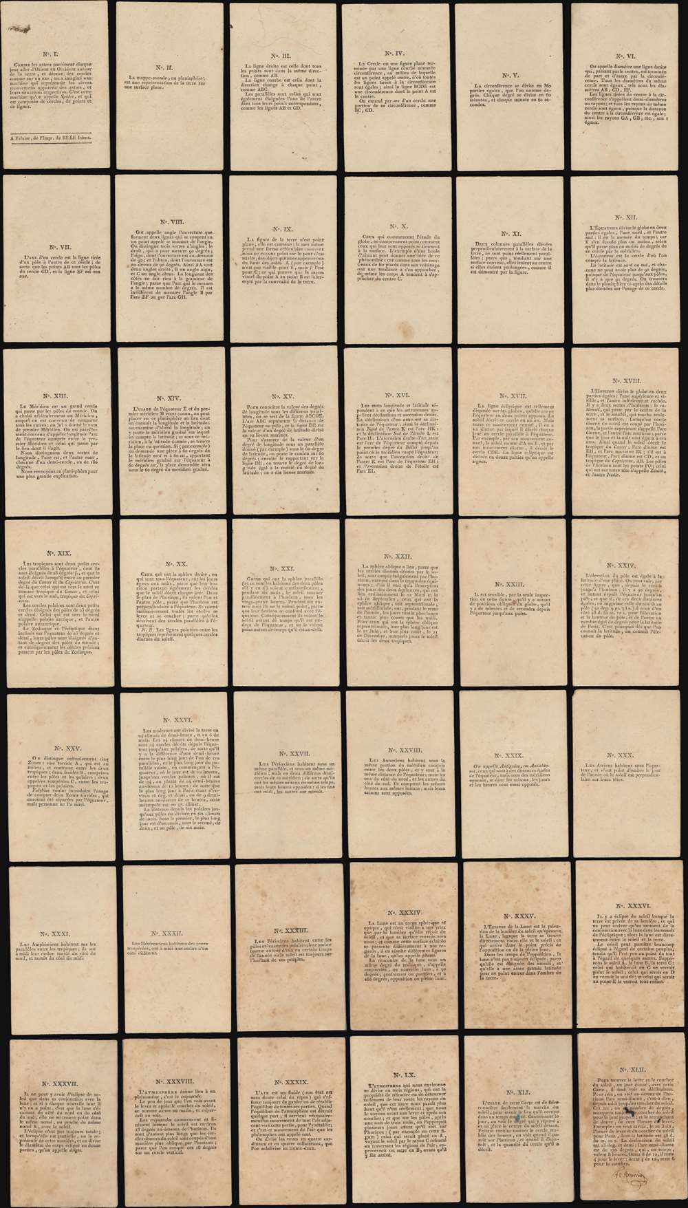
The following rules are translated from the accompanying rule sheet:'The Rules of the Game of New Astronomical and Geographical Cards'.
- Before starting to play, make a pile consisting of as many pieces of paper as there are cards in the Deck and assign them the value that you want.
- Since there are forty cards in the Deck, each card being numbered, two, four, five, six, or ten people can play, and divide the cards in the Deck equally between the players.
- After this division has been done, the eldest hand goes first. [Note: Elder is the non-dealer in two-hand games, otherwise, the player who has the lowest priority and who e.g. is the last to bid or play at the start of a game, often the dealer.] The player with the highest number wins the round and takes from the pile the corresponding number of pieces of paper as there are Cards played in the round. But to keep them, the player must explain the diagram on each card without looking at the explanation printed on the back. If they cannot explain them all, the player gives as many Cards and pieces of paper to the next eldest hand, and they fulfill the same task with the same penalties and rewards, and play continues in this manner for the rest of the game.
- The game can also be played in this manner without Cards 41 and 42.
- These last two cards can also be used during play. In that case two, three, six, and seven people can play, while still dividing the Cards equally amongst the players, and following the rules previously described.
Publication History and Census
The cards were engraved in Alençon, Normandy, by Pierre-François Godard, and published by Breé Freres of Falaise, France. The design and text are the work of Louis-Michel Pâris. We note a single cataloged example in OCLC: Yale University. This may be the only surviving complete set, including instructions, functional volvelles, box, and all cards.CartographerS
Louis-Michel Pâris (September 29, 1740 - June 16, 1806) was a French cleric, teacher, printer, and scientist. He was born in the town of Argentan, Normandy in 1740. Pâris entered the priesthood and upon taking orders, began teaching in his hometown of Argentan. During the French Revolution, Pâris was one of the priests who refused to take the Obligatory Oath, a statement of primary allegiance to France required by the July 12, 1790 law Constitution Civile du Clergé. Facing censure and possible arrest by the Revolutionary government, Pâris fled France on September 17 of 1792 and, along with many other refugees fleeing the revolution, established himself in London. There he befriended L'Abbé Carron of Rennes, and together they established a school for French Refugees in London, where hew taught for two years. Pâris remained in England for nine years, finally returning to Argentan in December of 1801, when the Concordat of 1801, an agreement between France and Pope Pius VII that reaffirmed the Roman Catholic Church as the majority church of France and restored some of its civil status, eliminated the Obligatory Oath requirement. Back in France, Pâris resumed his work teaching local children, ultimately founding a secondary school in 1803. He published several works, including one on geography and another on French grammar intended to aid his students. He also issued a set of geographical and astronomical cards. Pâris died suddenly in 1806. More by this mapmaker...
Pierre-François Godard (January 21, 1768 - July 22, 1838) was a French woodcut engraver active in Normandy during the late 18th and early 19th centuries. Pierre-François was born in Alençon, Normandy, where his father, Jean Godard (1735 - 1802), was also an engraver, printer, and bookbinder, although self-taught. As a young man he travelled to Nantes where he perfected engraving before returning to Alençon to establish himself as a bookseller and engraver. His earliest engravings date to 1787. He engraved various woodcuts for historical and fictional publications as well as card games for Bree Freres and Étienne de Jouy (1764-1846). Around 1814, citing deteriorating eyesight, Godard stopped engraving, and instead focused on his bookstore. Retiring, Godard sold his bookstore to Auguste-Jean Ruel in 1834. He died 4 years later. His son, Pierre-François Godard, generally known as Godard II d'Alençon (November 8, 1797 - December 15, 1864) was also a wood engraver and followed in the family tradition of bookselling and printing. Learn More...
Condition
Very good. 42 cards accompanied by the rules. All cards complete. Accompanied by original cardboard slipcase with the publisher's paper label.
References
D'Orville, M., Recherches historiques sur la Ville, les Évêques et le Diocèse de Sécy, (Falaise: Brée Freres) 1829, page 343-344. Daniel Crouch Rare Books, Catalog VI, No. 50. OCLC 1301756761.