This item has been sold, but you can get on the Waitlist to be notified if another example becomes available, or purchase a digital scan.
1878 Hayden Geological Map of Yellowstone National Park, Wyoming
GeologicalYellowstoneNP-hayden-1878$425.00

Title
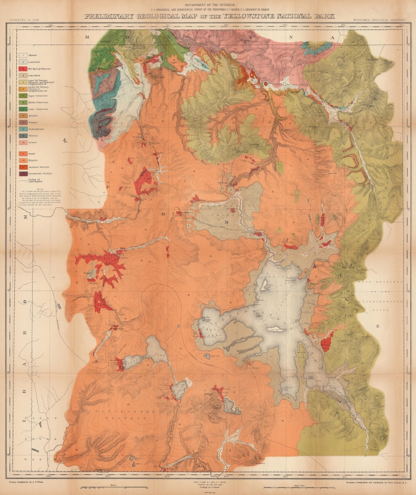
Preliminary Geological Map of the Yellowstone National Park.
1878 (dated) 34.5 x 28.5 in (87.63 x 72.39 cm) 1 : 126720
1878 (dated) 34.5 x 28.5 in (87.63 x 72.39 cm) 1 : 126720
Description
This is an 1878 Ferdinand V. Hayden geological map of Yellowstone National Park. Published only six years after the park's creation, this map represents one of the great American 19th century survey expeditions. Hayden's work was instrumental in inspiring Congress to create Yellowstone National Park, and the park system as an institution, in 1872.
A Closer Look
Brilliant colors differentiate eighteen geological zones: three different Cretaceous-era, Jurassic, and Triassic, along with hot springs deposits, dry lake beds, granite, and basalt. Additionally geyser basins, sulfur springs, mud geysers, and hot springs are labeled alongside waterfalls, rivers, creeks, and mountain peaks. Yellowstone Lake dominates the bottom right. The emerging road system is approximately mapped. The Continental Divide is illustrated by a black dashed line.The U.S. Geological and Geographical Survey of the Territories and the Hayden Survey
The U.S. Geological and Geographical Survey of the Territories (Hayden Survey) was created under the U.S. Department of the Interior in 1870, with Hayden as its director. It operated through 1879. The first year the Survey operated in Wyoming on a budget of $25,000 with twelve assistants and eight teamsters and cooks. The following year (1871), the Survey received $40,000 and employed thirty-two individuals, including artist Thomas Moran and photographer W. H. Jackson. That year they launched from Ogden, Utah (which the Union Pacific Railroad had reached) and spent the summer in what is now Yellowstone National Park. The work conducted by the survey that year played a critical role in convincing the U.S. Senate to create Yellowstone, the first U.S. National Park. The Survey worked in Colorado from 1873 through 1876 because of hostilities between white settlers and Native Americans in Wyoming. The team returned to the Yellowstone in 1877 and 1878. Then, in 1879, the Hayden Survey, along with surveys led by John Wesley Powell (the Colorado River and the Grand Canyon) and Clarence King (Fortieth Parallel Survey), were merged to create the U.S. Geological Survey.Publication History and Census
This map was created by William Henry Holmes and Ferdinand V. Hayden with triangulation work by Allen D. Wilson and Henry Gannett. It was issued as part of the Maps and Panoramas supplement to the Twelfth Annual Report of the United States Geological and Geographical Survey of the Territories, printed by Julius Bien. We note three examples cataloged in OCLC: University of California Davis, University of California Berkeley, and the David Rumsey Map Collection at Stanford. We also note an example at Northwestern University. The Maps and Panoramas supplement to the Twelfth Annual Report of the United State Geological and Geographical Survey of the Territories appears in just over two dozen collections per OCLC.CartographerS
Ferdinand Vandeveer Hayden (September 7, 1829 - December 22, 1887) was an American geologist remembered for leading late 19th century pioneering surveying expedition in the Rocky Mountains and served as a doctor in the Union Army during the U.S. Civil War. Born in Westfield, Massachusetts, and discovered a fascination with nature and wildlife in his youth. He studied at Oberlin College and graduated in 1850, then attended the Albany Medical College and earned his degree in 1853. While at Albany, Hayden garnered the attention of Professor James Hall, then the state geologist of New York. Professor Hall convinced Hayden to join an expedition to the Nebraska Territory, where he collected fossils and studied geology. He accompanied expeditions led by Gouverneur K. Warren in 1856 and 1857 and the Raynolds Expedition of 1860 led by Captain William F. Raynolds. He served as an army surgeon during the U.S. Civil War and rose to become the chief medical officer of the Army of the Shenandoah. After the war, Hayden resumed working on geologic and geographic surveys in the Nebraska and Western Territories and was appointed geologist-in-chief of the United States Geological and Geographical Survey of the Territories in 1867. Hayden led the first federally funded geological survey into the Yellowstone Region in northwestern Wyoming in 1871 under orders from Secretary of the Interior Columbus Delano. The expedition included fifty men, including painter Thomas Moran and Civil War photographer William Henry Jackson. Hayden's report on the expedition, Preliminary Report of the United State Geological Survey of Montana and Portions of Adjacent Territories; Being a Fifth Annual Report of Progress played an instrumental role in persuading Congress to establish Yellowstone as the first U.S. National Park. More by this mapmaker...
William Henry Holmes (December 1, 1846 - April 20, 1933) was an American geologist, cartographer, artist, explorer, archaeologist, scientific illustrator, anthropologist, museum curator, and mountain climber. Born on a farm near Cadiz, Ohio, and, in 1870, graduated from the McNeely Normal School in Hopedale, Ohio. Holmes briefly taught painting, drawing, geology, and natural history at the school before moving to Washington, D.C. to study art under Theodore Kaufmann in 1871. Holmes's talent for art soon garnered the attention of scientists at the Smithsonian Institution, who employed him to draw and sketch fossil shells and the shells of live mollusks. Holmes replaced Thomas Moran as the artist/topographer of the government survey of Ferdinand Vandeveer Hayden in 1872 and made his first expedition west to Yellowstone National Park. He earned a national reputation as a scientific illustrator during the 1870s and helped Hayden produce the Geological and Geographical Atlas of Colorado, And Portions of Adjacent Territory, published in 1877 and 1881. The Hayden Survey was absorbed by the U.S. Geological Survey in 1879, which allowed Holmes to leave for Munich, Germany, to further his art education under Frank Duveneck. While in Germany, he also studied 'museum making' at Dresden's Anthropology Museum under Adolphe B. Meyer. Holmes 'returned' to the U.S. Geological Survey upon his return to the United States and worked as a geologist and illustrator. In 1889 Holmes left the Geological Survey to join the Smithsonian Institution's Bureau of American Ethnology as an archaeologist. Then he worked as the curator of anthropology at the Field Columbian Museum in Chicago, Illinois from 1894 through 1897. In 1897 Holmes returned to Washington, D.C. to serve as the U.S. National Museum's head curator of anthropology. He served as chief of the Bureau of American Ethnology from 1902 through 1905 and then became the chairman of the U.S. National Museum's Division of Anthropology in 1910. He became the director of the National Gallery of Art (now the Smithsonian American Art Museum) in 1920. He retired from his position as Director of the National Gallery of Art in 1932 and moved to Royal Oak, Michigan, to live with his son. Learn More...
Henry Gannett (August 24, 1846 - November 5, 1914) was an American geographer who is described as the 'Father of American topographic map making'. Born in Bath, Maine, Gannett entered Harvard at the age of twenty and received a bachelor's degree in 1869. He earned the degree of mining engineer from the Hooper Mining School in 1870. He joined the Hayden Survey in 1871, at the age of twenty-one, and continued worked for its successor, the U.S. Geological Survey until his death. Gannett was among those lobbying to centralize all government mapmaking under one agency. Before the creation of the United States Geological Survey, individual mapmakers and agencies had to compete for money from Congress to fund projects. He became chief geographer of the U.S. Geological Survey, a position he held for fifteen years. Most of the Survey's map-making methods developed during his tenure as chief geographer. Gannett also earned a reputation as an indefatigable compiler of geographic materials. His first job with the USGS was geographer of the 1880 United States Census. The completion of the census in 1882 is considered the start of true topographical work in the United States and the birth of the quadrangle. Gannet served as chief geographer on two subsequent censuses, 1890 and 1900, and was one of the founding members of the National Geographic Society. Gannett was also one of the founders of the Association of American Geographers and the Geological Society of America. Gannet organized the Board of Geographic Names, which became a permanent part of the federal government and considers geographic names in official use. Gannett served as chairman of this Board from 1894. Upon his death, the Annals of the Association of American Geographers lamented, 'in the death of Henry Gannett American Science has lost one of the pioneers who had an important share in the development of geography in this country into an organized science'. Gannett married Mary E. Chase in 1874 with whom he had two daughters and a son. Learn More...
Allen David 'A.D.' Wilson (September 17, 1844 - February 21, 1920) was an American cartographer. Born in Sparta, Illinois, Wilson left school at twenty-three and enlisted in the Geological Survey of California, where he learned triangulation. He joined the Geological Exploration of the Fortieth Parallel led by Clarence King. He also participated in King's 1872 expedition to investigate the diamond hoax in the northwest corner of the Colorado Territory. Then, he joined the Hayden Geological Survey, and led a survey party throughout western Colorado, western Wyoming, and eastern Idaho from 1873 until 1878. The Hayden Survey merged with the U.S. Geological Survey in 1879 and that year Clarence King named Wilson U.S. Geological Survey chief topographer. Wilson remained with the U.S. Geological Survey until 1881, when he resigned to become the chief topographer of the Northern Transcontinental Survey. Wilson moved to Oakland, California, in the 1890s and helped organize the Athenian Bank, which was later renamed the Security Bank and Trust of Oakland. The bank was absorbed by the Bank of Italy in 1918 and soon became known as the Bank of America. Wilson died on February 21, 1920, of influenza. Learn More...
Julius (Julien) Bien (September 27, 1826 - December 21, 1909) was a German-Jewish lithographer and engraver based in New York City. Bien was born in Naumburg, Germany. He was educated at the Academy of Fine Arts, Cassell and at Städel's Institute, Frankfurt-am-Main. Following the suppression of the anti-autocratic German Revolutions of 1848, Bien, who participated in the pan-German movement, found himself out of favor in his home country and joined the mass German immigration to the United States. Bien can be found in New York as early as 1849. He established the New York Lithographing, Engraving & Printing Company in New York that focused on the emergent chromo-lithograph process - a method of printing color using lithographic plates. His work drew the attention of the U.S. Government Printing Office which contracted him to produce countless government maps and surveys, including the Pacific Railroad Surveys, the census, numerous coast surveys, and various maps relating to the American Civil War. Bien also issued several atlases both privately and in conjunction with a relation, Joseph Bien. At the height of his career Bien was elected president of the American Lithographers Association. After his death in 1909, Bien's firm was taken over by his son who promptly ran it into insolvency. The firm was sold to Sheldon Franklin, who, as part of the deal, retained the right to publish under the Julius Bien imprint. In addition to his work as a printer, Bien was active in the New York German Jewish community. He was director of the New York Hebrew Technical Institute, the New York Hebrew Orphan Asylum, and president of the B'nai B'rith Order. Learn More...
Condition
Good. Wear and toning along original fold lines. Verso repairs to fold separations and at fold intersections. Small areas of infill at some fold intersections. Closed tear extending two-and-one-half (2.5) inches into printed area from bottom edge professionally repaired on verso.
References
Rumsey 5947.000. OCLC 21604642, 953570025.