This item has been sold, but you can get on the Waitlist to be notified if another example becomes available, or purchase a digital scan.
1847 Bonner First Edition Wall Map of Georgia - First official map of Georgia
Georgia-bonner-1847$42,500.00

Title
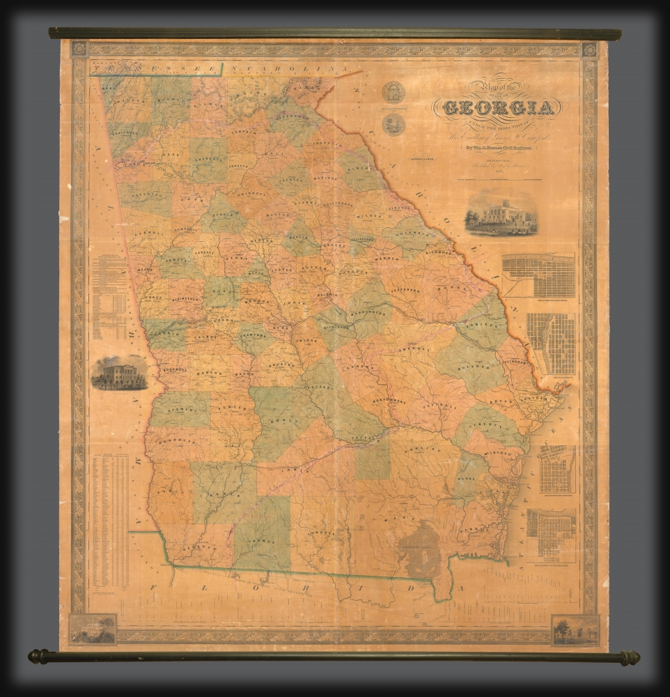
Map of the State of Georgia compiled under the direction of His Excellency George W. Crawford by Wm. G. Bonner, Civil Engineer.
1847 (dated) 62 x 52 in (157.48 x 132.08 cm) 1 : 362057
1847 (dated) 62 x 52 in (157.48 x 132.08 cm) 1 : 362057
Description
An excellent example of William G. Bonner's rare, important, and monumental 1847 map of Georgia, here in its first edition, first state. When issued, this was the first major map of the state to appear in almost 20 years, and thus the first to represent Georgia with some approximation of its modern borders. It is, moreover, the first major map to illustrate the westward expansion of Georgia in the 1830s and 40s, with the annexation of Creek and Cherokee territory. It is also one of the few maps to clearly delineate the Georgia-Florida border dispute.
A Closer Look
The map is large and meticulously rendered, illustrating topography, river systems, roads (with mileage), railroads (extant and proposed), counties, cities, and towns. There are inset plans of Augusta, Columbus, Macon, and Savannah, as well as vignettes of the State House, Governor's Mansion, the Female College at Macon, Augusta Medical College, and the University of Georgia. Elevation charts in the lower quadrants detail the routes of several early Georgia railroads. The whole is surrounded by a neoclassical border with vignettes and rosette medallions in the corners.A New Map of Georgia
By the mid-1840s, the existing cartography of Georgia was woefully inadequate for state-wide administrative purposes. The best available cartography remained the 1818 Daniel Struges map, which predated Georgia's 1828 annexation of Creek and Cherokee Territory and the 1830 Indian Removal Act: events that, combined, more than doubled Georgia's size. With settlers flooding into western Georgia, new towns and counties were being chartered at a breakneck pace. The situation was described by the New York Herald,The first knowledge we have of the geography of Georgia, was obtained from a map of that State published between forty and fifty years ago, by Elizur Early [i.e., the Sturges map]. At that time, the country west of the Ocmulgee and north-west of the Chattahoochee River, was in the occupancy of the Creek and Cherokee Indians, and never having been surveyed, was represented on Early's map as unexplored territory. About the year 1833, Orange Green published a small map of the State, on which was delineated the districts of the Creek and Cherokee purchases, as they had been laid off into lots by authority of the Legislature. Since the publication of Green's map, the number of counties has increased from 90 to 112, Over one thousand miles of railroad have been constructed, and fifty cotton factories, and four hundred and fifty post offices have been established. There are now, besides, the above, 1,500 miles [of railroad] mapped and in course of construction.- (New York Herald, reprinted in Macon Weekly Telegraph, vol. XXVII no. 45, June 20, 1854, p. 2)The Georgia General Assembly, nonetheless, lacked the means and commitment to produce its own map, a sharp contrast to well-funded cartographic efforts, such as in Massachusetts. Enter William Bonner, a capable and driven civil engineer and Georgia native with a prestigious West Point pedigree. Bonner proposed an ambitious reconsideration of existing cartographic materials held at the Milledgeville statehouse. With this data, he argued one could compile a new accurate map without the onerous expenditure of extensive new survey efforts. To supplement this data, he petitioned individual towns and counties for available data, ranging from privately funded property surveys, to railroad surveys, to local incorporation documents. His work is described in the Macon Weekly Telegraph,
We have witnessed the progression of this work, since its commencement, almost daily. It has been executed at the Capitol, where reference has been easy to the statutes regulating boundary lines, and to all the surveys ever ordered by the State authorities (November 24, 1846).The final work, submitted for engraving and printing in late 1846 or early 1847, was justly received with glowing praise. It was the largest scale map of Georgia to date, emphasizing both the evolving political structures and the state's varied natural topography. It was lauded in local and national newspapers, and received the backing of the General Assembly, which ordered 130 copies of the first edition for distribution to each county and other states. Even Georgia Governor George W. Crawford, praised Bonner. In a November 2, 1847 message to the State Assembly, he suggests,
It appears that Mr. B[onner] is exceedingly desirous of having a particularly correct outline of each county, with all the public places therein, or whatever may be of local or general interest, noted with care. For this purpose, he has furnished a number of counties in the State, through the Executive, with a rough map upon which the Inferior Court were requested to [sic] have dotted and marked the particulars above referred to, and return the same (June 9, 1846).
Whether in respect to his toil or the value of [Bonner's] work in a public view, I am of opinion that the subscription [to 130 copies] already mentioned is not an adequate recompense to him, and cheerfully recommend additional compensation to such amount as may comport with the justice and liberality of the Legislature.
Florida-Georgia Boundary Dispute
This map provides one of the best and most detailed illustrations of the Florida-Georgia Boundary Dispute. Although dating to the colonial period, the dispute reached its apex after 1845, when Florida achieved statehood. The confusion relates to the location of the 'true' headwaters of the St. Mary's River – the point agreed upon as the eastern terminus of the border by the 1795 Pinckney's Treaty between the United States and Spain. Three conflicting boundaries are indicated. All run eastward from the confluence of the Chattahoochee and Thronateeska Rivers (Flint River), which thus form the Apalachicola River. The southernmost line agrees with the 1831 Georgia-sponsored Crawfurd-Cooper boundary commission, which determined the source of the St. Mary's to be Lake Randolph, well to the south of all previous borders. A second line, slightly further north, described here as 'the supposed true line', terminates at a point where the St. Mary's River divides into Northern and Western Branches. Further north still, terminating at Ellicot's Mound, named after Andrew Ellicot, the surveyor who built the mound in 1799, is McNeil's Line, surveyed in 1825. While Georgia pushed for the 1831 Crawfurd-Cooper Boundary, Florida argued for the more northerly McNeil Line. The dispute was finally resolved in 1855, when state governors both agreed on McNeil's Line, an agreement later backed up by the Supreme Court. Although this map significantly predates the formal adoption of the McNeil Line, all examples of this 1847 first edition terminate color coding at McNeil's Line - suggesting perhaps that Bonner himself believed it to be the correct boundary.Manuscript Annotation of De Soto's Supposed Route
Faint but readable old manuscript annotation traces the likely track of the Hernando de Soto expedition, naming American Indian villages along the route. The scholar who annotated this map proposes a route almost entirely in Georgia, situating major settlements recorded by the De Soto narrative well to the south of most conventional scholarship. The route proposed here enters Georgia from the west along the Coosa River, then runs northeast towards the Tugaloo River, which it loosely follows southwest until it turns into the Savannah River. The route turns southwest near Jacksonville until it reaches the Oconee River, which it follows south, crossing at that river's convergence with the Ocmulgee and Altamaha Rivers. It then follows the Ocmulgee River west until breaking off to the southwest near Spalding. The expedition then traveled southwest and south overland, crossing into Florida near Lake Iamonee (Lake Iamonia). The large American Indian settlements De Soto's chroniclers describe are named, among them Cofitachequi, Tuscaluza, Coosa, Ocute, Joara, and others. To this day, few, if any, of these sites have been positively identified and remain the subject of significant scholarly debate.Publication History and Census
Bonner began compiling this map in 1845 or 1846, with the work taking a reported 18 months. It was engraved and printed in New York by Sherman and Smith, but published in Milledgeville, then Georgia's state capital. We see records that some 130 examples of this first edition were ordered, one of which was disseminated to each state of the Union. Others were sold by subscription, so no true tally is available. Editions followed in 1851, 1854, 1857, and 1859. Extremely rare. This first edition is held in 3-4 institutions. We locate just one other example of the first state appearing on the market, and very few examples of subsequent states.CartographerS
William G. Bonner (c. 1813 - 1889) was an American civil engineer, surveyor, and cartographer based in Milledgeville, Georgia. Bonner was born in Hancock County, Georgia. He is extremely elusive. We believe it is the W. G. Bonner of Georgia who was admitted as a cadet to the U.S. Military academy at West Point in 1828, when he was 14, and dismissed in 1831. It is likely there that he was trained in surveying and civil engineering. We next find him in Milledgeville, where he complied the seminal 1847 Map of the State of Georgia. Perhaps riding on the success and good reception of this map, in 1848 Bonner was elected Chief Engineer of the East Tennessee and Georgia Railroad. He later served in the same role for the Macon and Warrington Railroad, and the Vicksburg and Shreveport Railroad. He served the Confederate cause during the American Civil War (1861 - 1865), with the rank of colonel. He appears to have owned one slave, a servant named Abram. Afterwards, in 1869, we find a 'William G. Bonner' working as a Civil Engineer in Kingston, New York, and, in 1870, in New York City. We see no records past 1889. More by this mapmaker...
Sherman and Smith (fl. c. 1829 - 1855), sometimes working as Stiles, Sherman & Smith, were American engravers active in New York City during the middle part of the 19th century. The firm including John Calvin Smith (surveyor and engraver), George E. Sherman, and sometimes, Samuel Stiles. Their work primarily focused on government publications, including the maps and engravings prepared to illustrate the official records of the 1838-42 United States Exploring Expedition (U.S. Ex. Ex.), maps issued for the Army Corps of Topographical Engineers, and various U.S. Coast Survey Charts. They also engraved privately for Thomas Bradford and John Disturnell, among others. Sherman and Smith maintained offices at the corner of Broadway and Liberty Street in New York City and were highly regarded as the finest cartographic engravers in the city. Their non-cartographic legacies include George Inness, who apprenticed with them for two years before going on to become a well regarding American landscape painter of the Hudson River School. Learn More...
Condition
Good. Overall toning. Some edge chipping. Some verso reinforcement to linen at top. Otherwise a clean example in original unrestored condition.
References
OCLC 36724614.