This item has been sold, but you can get on the Waitlist to be notified if another example becomes available, or purchase a digital scan.
1794 Laurie and Whittle Map of Florida, Georgia, Carolina
GeorgiaFlorida-lauriewhittle-1794$1,975.00

Title
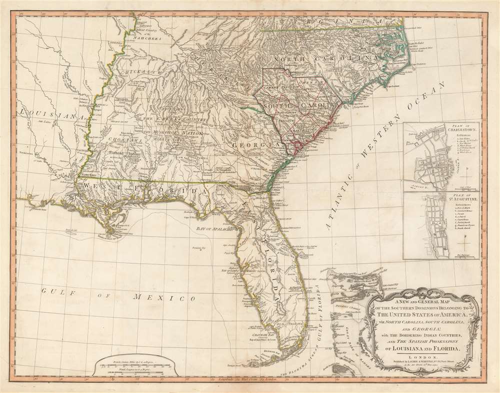
A New and General Map of the Southern Dominions Belonging to The United States of America, viz: North Carolina, South Carolina, and Georgia: with the Bordering Indian Countries, and The Spanish Possessions of Louisiana and Florida.
1794 (dated) 20.5 x 26.25 in (52.07 x 66.675 cm) 1 : 3168000
1794 (dated) 20.5 x 26.25 in (52.07 x 66.675 cm) 1 : 3168000
Description
A scarce 1794 map of the southeastern part of the United States and Florida issued by the London firm of Laurie and Whittle. The coverage extends from North Carolina to the Florida Keys and from just beyond the Mississippi River to the Atlantic seaboard and the Bahamas. It encompasses the modern-day states of North Carolina, South Carolina, Georgia, Kentucky, Tennessee, Alabama, Mississippi, Louisiana (very little detail), and Florida. At right, there are inset detail maps of Charleston and St. Augustine.
A Field Aid During the Revolutionary War
This map was initially designed by Robert Sayer to be an essential field aid to British officers during the American Revolutionary War (1775 - 1783). As such, it offers a wealth of fascinating detail, particular as regards the American Indian nations in the western part of the map. It identifies lands and territories associated with various important Amerindian nations, including the Creek, Muskogee, Cherokee, Choctaw, Chickasaw, Natchez, and multiple subgroups and smaller tribes. It further notes trade routes to the various tribal nations, including the famed Upper Path, the Middle Path, and the Lower Path - major trade arteries to the Creek nations.Sources
Cartographically it is a compilation of the finest maps available of the region c. 1776, and was derived from the works of Bernard Romans (c. 1720 - 1784), William Gerard De Brahm (1717 - 1799), Collet (Collett), John Abraham Collet (Collett, fl. 1756 - 1789) and Henry Mouzon (1741 - 1807). Although the present edition postdates the first edition by nearly 20 years, the cartography remains largely unchanged.Publication History and Census
This map was first issued Robert Sayer and John Bennett in 1776 for British field officers during the American Revolutionary War (1775 - 1783). It was part of a six-map dissected pocket atlas known, comonly, as the Holster Atlas. The present example is the second edition, engraved for Laurie and Whittle in 1794 for their edition of Thomas Kitchin's General Atlas. While cartographically similar, the present edition is notable for its revision to include the 'United States of America' in the title.CartographerS
Laurie and Whittle (fl. 1794 - 1858) were London, England, based map and atlas publishers active in the late 18th and early 19th century. Generally considered to be the successors to the Robert Sayer firm, Laurie and Whittle was founded by Robert Laurie (c. 1755 - 1836) and James Whittle (1757-1818). Robert Laurie was a skilled mezzotint engraver and is known to have worked with Robert Sayer on numerous projects. James Whittle was a well-known London socialite and print seller whose Fleet Street shop was a popular haunt for intellectual luminaries. The partnership began taking over the general management of Sayer's firm around 1787; however, they did not alter the Sayer imprint until after Sayer's death in 1794. Apparently Laurie did most of the work in managing the firm and hence his name appeared first in the "Laurie and Whittle" imprint. Together Laurie and Whittle published numerous maps and atlases, often bringing in other important cartographers of the day, including Kitchin, Faden, Jefferys and others to update and modify their existing Sayer plates. Robert Laurie retired in 1812, leaving the day to day management of the firm to his son, Richard Holmes Laurie (1777 - 1858). Under R. H. Laurie and James Whittle, the firm renamed itself "Whittle and Laurie". Whittle himself died six years later in 1818, and thereafter the firm continued under the imprint of "R. H. Laurie". After R. H. Laurie's death the publishing house and its printing stock came under control of Alexander George Findlay, who had long been associated with Laurie and Whittle. Since, Laurie and Whittle has passed through numerous permeations, with part of the firm still extant as an English publisher of maritime or nautical charts, 'Imray, Laurie, Norie and Wilson Ltd.' The firm remains the oldest surviving chart publisher in Europe. More by this mapmaker...
Robert Sayer (1725 - January 29, 1794) was an important English map publisher and engraver active from the mid to late 18th century. Sayer was born in Sunderland, England, in 1725. He may have clerked as a young man with the Bank of England, but this is unclear. His brother, James Sayer, married Mary Overton, daughter-in-law of John Overton and widow of Philip Overton. Sayer initially worked under Mary Overton, but by December of 1748 was managing the Overton enterprise and gradually took it over, transitioning the plates to his own name. When Thomas Jefferys went bankrupt in 1766, Sayer offered financial assistance to help him stay in business and, in this way, acquired rights to many of the important Jefferys map plates as well as his unpublished research. From about 1774, he began publishing with his apprentice, John Bennett (fl. 1770 - 1784), as Sayer and Bennett, but the partnership was not formalized until 1777. Bennett retired in 1784 following a mental collapse and the imprint reverted to Robert Sayer. From 1790, Sayer added Robert Laurie and James Whittle to his enterprise, renaming the firm Robert Sayer and Company. Ultimately, Laurie and Whittle partnered to take over his firm. Sayer retired to Bath, where, after a long illness, he died. During most of his career, Sayer was based at 53 Fleet Street, London. His work is particularly significant for its publication of many British maps relating to the American Revolutionary War. Unlike many map makers of his generation, Sayer was a good businessman and left a personal fortune and great estate to his son, James Sayer, who never worked in the publishing business. Learn More...
Condition
Very good. Minor wear on old fold lines.
References
OCLC 51953179. Tooley (Amer) pp. 98-9, #78-b.