1710 Homann Map of the Holy Roman Empire
Germany-homann-1707$750.00

Title
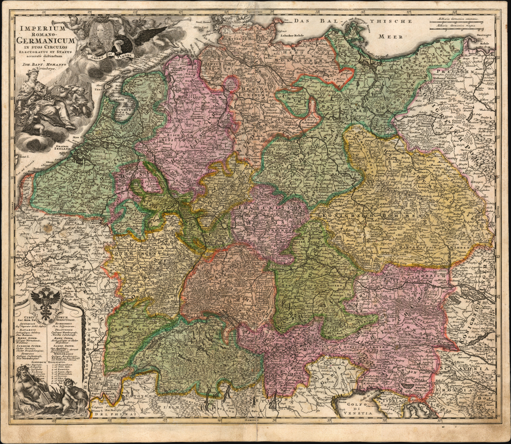
Imperium Romano-Germanicum in suos Circulos Electoratus et Status accurate distinctum a Ioh. Bapt. Homanno Norimbergae.
1707 (undated) 19.25 x 23 in (48.895 x 58.42 cm) 1 : 2350000
1707 (undated) 19.25 x 23 in (48.895 x 58.42 cm) 1 : 2350000
Description
This is the scarce 1707/10 first plate of Johann Baptist Homann's map of the Holy Roman Empire, produced shortly after the 1705 elevation of Joseph I as Emperor.
In the lower left is a framed table listing the ten circles (administrative regions) of the Empire and a key to symbols and numbers used. The table is surmounted with the Imperial arms, while at its foot are two Potamoi, river gods here symbolizing the Rhine and the Danube.
A Closer Look
The map presents the Holy Roman Empire following the 1648 Peace of Westphalia. Coverage incorporates not only the area of modern-day Germany and Austria, but also what is now the Czech Republic, the Low Countries, Switzerland, and the County of Burgundy. This is Homann's second map of the Holy Roman Empire (the first was engraved in 1690 for David Funck). The 1707 edition of Homann's atlas included this newly-engraved map, which is notably superior to the earlier Funck engraving. Cartographically, its detail is comparable, albeit changing many of the Latinized placenames to their German orthography (for example, Mähren instead of Moraviae). But the primary impetus behind Homann's new map was to honor the new Emperor: with the death of Leopold I, Joseph I succeeded to both the thrones of Bohemia and the Holy Roman Empire. This is clearest in the allegorical cartouche. Joseph's portrait is presented amid a flock of putti, with his Latin motto - Amore et Timore, 'By Love and Fear' - emblazoned on a banner below; the putti bear his crown, and blow horns - a symbol of fame. Below, others of the flock attend a seated Italia turrita, a symbol of the Italian state and by extension the Holy Roman Empire. One of her putti lifts a pillow towards Joseph, bearing the two keys symbolizing his authority over the Church.In the lower left is a framed table listing the ten circles (administrative regions) of the Empire and a key to symbols and numbers used. The table is surmounted with the Imperial arms, while at its foot are two Potamoi, river gods here symbolizing the Rhine and the Danube.
A Short-Lived Plate
As early as 1712, this plate was replaced with another, replacing Joseph I's portrait and motto with that of his successor Charles VI; we see yet another plate with the cartouche altered to include a stylized globe beside the Italia Turrita, and still another with a 1732 date. There is no consistency between institutional listings of these maps, and no credible chronology of these latter plates.Publication History and Census
This map was engraved as early as 1705, but first appeared in Homann's 1707 Neuer Atlas, the present example being from the 1710 2nd edition of that work. Given the profusion of later plates and universal confusion over their dating, it is not possible to make a definitive census; however, the four-year window within which this plate was in production makes it likely that this is a scarce imprint.Cartographer
Johann Baptist Homann (March 20, 1664 - July 1, 1724) was the most prominent and prolific map publisher of the 18th century. Homann was born in Oberkammlach, a small town near Kammlach, Bavaria, Germany. As a young man, Homann studied in a Jesuit school and nursed ambitions of becoming a Dominican priest. Nonetheless, he converted to Protestantism in 1687, when he was 23. It is not clear where he mastered engraving, but we believe it may have been in Amsterdam. Homann's earliest work we have identified is about 1689, and already exhibits a high degree of mastery. Around 1691, Homann moved to Nuremberg and registered as a notary. By this time, he was already making maps, and very good ones at that. He produced a map of the environs of Nürnberg in 1691/92, which suggests he was already a master engraver. Around 1693, Homann briefly relocated to Vienna, where he lived and studied printing and copper plate engraving until 1695. Until 1702, he worked in Nuremberg in the map trade under Jacob von Sandrart (1630 - 1708) and then David Funck (1642 - 1709). Afterward, he returned to Nuremberg, where, in 1702, he founded the commercial publishing firm that would bear his name. In the next five years, Homann produced hundreds of maps and developed a distinctive style characterized by heavy, detailed engraving, elaborate allegorical cartouche work, and vivid hand color. Due to the lower cost of printing in Germany, the Homann firm could undercut the dominant French and Dutch publishing houses while matching their diversity and quality. Despite copious output, Homann did not release his first major atlas until the 33-map Neuer Atlas of 1707, followed by a 60-map edition of 1710. By 1715, Homann's rising star caught the attention of the Holy Roman Emperor Charles VI, who appointed him Imperial Cartographer. In the same year, he was also appointed a member of the Royal Academy of Sciences in Berlin. Homann's prestigious title came with several significant advantages, including access to the most up-to-date cartographic information as well as the 'Privilege'. The Privilege was a type of early copyright offered to very few by the Holy Roman Emperor. Though less sophisticated than modern copyright legislation, the Privilege offered limited protection for several years. Most all J. B. Homann maps printed between 1715 and 1730 bear the inscription 'Cum Priviligio' or some variation. Following Homann's death in 1724, the firm's map plates and management passed to his son, Johann Christoph Homann (1703 - 1730). J. C. Homann, perhaps realizing that he would not long survive his father, stipulated in his will that the company would be inherited by his two head managers, Johann Georg Ebersberger (1695 - 1760) and Johann Michael Franz (1700 - 1761), and that it would publish only under the name 'Homann Heirs'. This designation, in various forms (Homannsche Heirs, Heritiers de Homann, Lat Homannianos Herod, Homannschen Erben, etc.) appears on maps from about 1731 onwards. The firm continued to publish maps in ever-diminishing quantities until the death of its last owner, Christoph Franz Fembo (1781 - 1848). More by this mapmaker...
Source
Homann, J. B., Neuer Atlas bestehend in einig curieusen Astronomischen Kuppren und vielen auserlesenen accuratensten Land-Charten über die Gantze Welt, (Nuremberg: Homann) 1710.
Homann's Neuer Atlas bestehend in einig curieusen Astronomischen Kuppren und vielen auserlesenen accuratensten Land-Charten über die Gantze Welt was first publihsed in 1707 with 33 maps. A second edition followed in 1710 with 60 maps. Subsequent editions followed until about 1730. The title page notes proudly that the atlas features measurements based on the 'Copernican principle of the moving sky', a truly state-of-the-art innovation for the period. Regardless of editions, collations of the atlas are inconsistent, with some examples having less, while others have more maps - a consequence of the fact that the map sheets were delivered loose, to be bound at the buyer's discretion, and so some buyers chose to omit maps they did not consider relevant, or add others they did. Between editions, the constituent maps, particularly of European regions, were regularly updated to reflect the most recent political events. The atlas continued to be published by Homann's son, J. C. Homann (1703 - 1730), and then by Homann Heirs. Most examples also feature a fine allegorical frontispiece with the title Atlas Novus Terrarum Orbis Imperia, regna et Status, which was used for multiple Homann atlases, including the Neuer Atlas and the Atlas Minor.
Condition
Very good. Mended centerfold separation at bottom. Original outline and wash color.
References
OCLC 1029761136 (misdated 1724). Not in Rumsey: compare 12499.092 (c. 1716 second plate).