
1540 / 1552 Münster Map of Germany

This item has been sold.
Germania VI. Nova Tabula.
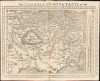
Attractive, southern-oriented map of Germany.
- Digital Map Information
- Suitable for large format printing
- Full resolution TIFF file
- ICC color profile embedded
- Delivered instantly via download link
Attractive, southern-oriented map of Germany.
This is a superb example of Sebastian Münster's modern map of Germany and Central Europe, in a desirable 1552 Geographia edition. It is one of the earliest acquirable modern maps of the heart of Europe.A Closer Look
This beautifully executed woodcut, oriented to the south, presents Central Europe from Gdansk in the east to Antwerp in the west and from Hamburg and Lübeck in the north to part of Croatia in the south. While focusing primarily on Germany, the map highlights Austria, Bavaria, Swabia, and Bohemia; parts of Poland and Prussia are shown in the east, while the Rhineland is detailed in the west, from Holland to Switzerland. The Alps dominate the top of the map and are pictorially rendered; forests are also depicted throughout, particularly those circling Bohemia. At right, a scale of common German miles is provided. Surrounding the map are coordinate bars - not latitude or longitude, but a number guide to aid in guiding students to locations on the map (a feature unique to the 1552 edition of Geographia). In the lower right, a Viking longship can be seen rowing into view.The Southern Orientation
The southern orientation, which distinguishes this map (as well as Münster's 1540 map of Europe, among others), was neither an error, nor a regression, nor a touch of whimsy. It was an indication of the map's modernity. The convention of keeping north at the 'top' of a map was inherited from Ptolemy's maps. Maps produced by Münster based on Ptolemaic sources retained that second-century geographer's northern orientation. However, regional maps printed in Germany in the first part of the 16th century for the use of travelers were oriented to the south, to be used in conjunction with a solar compass. Since these represented Münster's most accurate and detailed modern sources, his maps derived from them virtually all shared the same southern orientation. Münster's adherence to a southern orientation derives from his study of Martin Waldseemüller (1470 - 1520) and Erhard Etzlaub (1455 - 1532) before him.Publication History and Census
This map first appeared in the 1540 edition of Münster's Geographia and appeared in all four editions of that work. Only the 1552 edition of it included the coordinate bars. The map also appeared in all editions of Münster's Cosmographia from 1544 to 1578. The present example corresponds both typographically and with respect to the bars to the map found in the 1552 Geographia edition. The book is well represented in institutional collections; this specific 1552 state of the map is not cataloged separately in OCLC. The map appears on the market from time to time in its various editions, but the 1552 Geographia state is scarce, and examples of any edition of this map in this quality grow difficult to find.Cartographers
Sebastian Münster (January 20, 1488 - May 26, 1552), was a German cartographer, cosmographer, Hebrew scholar and humanist. He was born at Ingelheim near Mainz, the son of Andreas Munster. He completed his studies at the Eberhard-Karls-Universität Tübingen in 1518, after which he was appointed to the University of Basel in 1527. As Professor of Hebrew, he edited the Hebrew Bible, accompanied by a Latin translation. In 1540 he published a Latin edition of Ptolemy's Geographia, which presented the ancient cartographer's 2nd century geographical data supplemented systematically with maps of the modern world. This was followed by what can be considered his principal work, the Cosmographia. First issued in 1544, this was the earliest German description of the modern world. It would become the go-to book for any literate layperson who wished to know about anywhere that was further than a day's journey from home. In preparation for his work on Cosmographia, Münster reached out to humanists around Europe and especially within the Holy Roman Empire, enlisting colleagues to provide him with up-to-date maps and views of their countries and cities, with the result that the book contains a disproportionate number of maps providing the first modern depictions of the areas they depict. Münster, as a religious man, was not producing a travel guide. Just as his work in ancient languages was intended to provide his students with as direct a connection as possible to scriptural revelation, his object in producing Cosmographia was to provide the reader with a description of all of creation: a further means of gaining revelation. The book, unsurprisingly, proved popular and was reissued in numerous editions and languages including Latin, French, Italian, and Czech. The last German edition was published in 1628, long after Münster's death of the plague in 1552. Cosmographia was one of the most successful and popular books of the 16th century, passing through 24 editions between 1544 and 1628. This success was due in part to its fascinating woodcuts (some by Hans Holbein the Younger, Urs Graf, Hans Rudolph Manuel Deutsch, and David Kandel). Münster's work was highly influential in reviving classical geography in 16th century Europe, and providing the intellectual foundations for the production of later compilations of cartographic work, such as Ortelius' Theatrum Orbis Terrarum Münster's output includes a small format 1536 map of Europe; the 1532 Grynaeus map of the world is also attributed to him. His non-geographical output includes Dictionarium trilingue in Latin, Greek, and Hebrew, and his 1537 Hebrew Gospel of Matthew. Most of Munster's work was published by his stepson, Heinrich Petri (Henricus Petrus), and his son Sebastian Henric Petri. Further Details...
Heinrich Petri (1508 - 1579) and his son Sebastian Henric Petri (1545 – 1627) were printers based in Basel, Switzerland. Heinrich was the son of the printer Adam Petri and Anna Selber. After Adam died in 1527, Anna married the humanist and geographer Sebastian Münster - one of Adam's collaborators. Sebastian contracted his stepson, Henricus Petri (Petrus), to print editions of his wildly popular Cosmographia. Later Petri, brought his son, Sebastian Henric Petri, into the family business. Their firm was known as the Officina Henricpetrina. In addition to the Cosmographia, they also published a number of other seminal works including the 1566 second edition of Nicolaus Copernicus's De Revolutionibus Orbium Coelestium and Georg Joachim Rheticus's Narratio. Further Details...
Source
Münster, S., Geographia, (Basel: Petri) 1552.
Following in the footsteps of Martin Waldseemuller and Lorent Fries before him, Sebastian Munster edited and published a modernized version of Claudius Ptolemy's Geographia. This appeared in six Latin editions in 1540, 1541, 1542, 1545, 1551 and 1552. According to Karrow, Munster based the text on the Latin translation of Willibald Pirkheimer, but he carefully collated it with previous editions, adding notes of his own. The first three editions contained 48 maps, consisting of 27 based on Ptolemy's ancient geography, and 21 maps based on modern geographical knowledge. The latter three editions contained 54 maps, comprised of the same ancient works but with six of the modern maps discarded, and twelve new ones added. For the collector, the modern maps are of sharpest interest. Some were based on Waldseemuller's geography, but many were based on Munster's own surveys and those of other European geographers whose assistance Munster had been able to enlist. Most of these would be reprised in Munster's magnum opus, Cosmographia Universalis. A disproportionate number of Munster's modern maps show contemporary geographical knowledge of the their respective areas for the very first time: The first map to show the continents of the Western Hemisphere; the first map to focus on the continent of Asia; the first modern map to name the Pacific Ocean. Even in cases where earlier maps exist, Munster's works very often remain the earliest such acquirable by the collector.
Condition
Excellent. Light toning. Small wormhole at bottom centerfold outside image, else fine.
References
OCLC 1246291271 (1540). Rumsey 11623.075 (1540).