
1946 U.S. State Department Map of Germany Post World War II Allied Occupation Zones

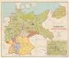
Germany Zones of Occupation.
An official U.S. State Department map of Occupation Zones in Post-War Germany.
$950.00
Choose a Collection:
- Digital Map Information
- Suitable for large format printing
- File Size: 178.99 MB
- File Type: ZIP / TIFF
- ICC color profile embedded
- Delivered instantly via download link
This Item
Enquire
An official U.S. State Department map of Occupation Zones in Post-War Germany.
This is a 1946 Division of Map Intelligence and Cartography map of occupied Germany after World War II (1939 - 1945). Bold lines delineate British, American, French, Soviet, and Polish occupation zones. Berlin, within the Soviet Occupation Zone, was jointly occupied by the British, Americans, French, and Soviets, as detailed in the lower right.The Allied Occupation of Germany
The United States, Great Britain, and the Soviet Union agreed to divide conquered Germany into zones of occupation at the February 1945 Yalta Conference. The more comprehensive plan to create four separate zones was ratified at the subsequent Potsdam Conference. Unfortunately, the cordiality between the Western Allies and the Soviet Union began evaporating soon after the war, and by 1947 any effort to govern Germany jointly floundered. The British and American zones merged on January 1, 1947, creating the jointly administered 'Bizone'. This entity was soon joined by the French zone, necessitating a name change to 'Trizone'. In May 1949, these zones merged to form the Federal Republic of Germany (West Germany). In October 1949, the Soviets established the German Democratic Republic (East Germany). The occupation in West Germany continued until May 5, 1955, when the General Treaty transferred governance from the Allied military governments to civilian German leaders. East Germany remained under Soviet control until 1990.Publication History and Census
This map was created and published by the Division of Map Intelligence and Cartography of the United States Department of State. It is well represented in institutional collections. Rare on the private market.Condition
Very good. Light wear along original fold lines.
References
OCLC 36052909.