This item has been sold, but you can get on the Waitlist to be notified if another example becomes available, or purchase a digital scan.
1844 Missionary Double Hemisphere Pictorial Map of the World
Weltkarte-missionsanstaltbasel-1844$475.00

Title
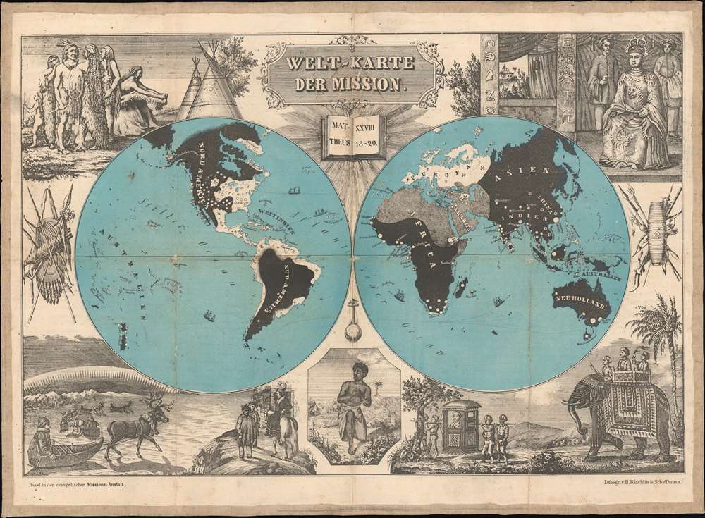
Welt-Karte der Mission.
1844 (undated) 14 x 19 in (35.56 x 48.26 cm)
1844 (undated) 14 x 19 in (35.56 x 48.26 cm)
Description
This is an early edition of a missionary map published by the Basel Evangelical Mission (Der evangelischen Missions-Anstalt Basel) in Switzerland. It illustrates the Mission's ongoing struggle to convert the world - believed to be a prerequisite for the Second Coming. A striking allegorical surround illustrates the unconverted peoples of the world, perhaps with the intention if inspiring future missionaries with wonder at the exoticism.
In the lower right, we see the Indian Maharajah in a splendid four-person litter followed by a regally draped elephant. In the center of the bottom panel is a disturbing image of a shackled African whose face expresses the unimaginable fear and confusion associated with his condition. And finally, in the lower left corner, we see a scene representing the wild peoples of the Polar regions, seemingly represented by Sami or Siberian peoples. Floating above it all is an ornate title cartouche, under which is depicted a radiant book with the Biblical call to mission:
A Closer Look
The world is here divided into three distinct spheres: Christian areas (white), the Islamic World (Arabien; gray), and areas still unexposed to the gospel of Jesus Christ (black). The surrounding oceans rendered in a contrasting blue' The geography is not only indicative of the time in which the map was produced - with era-specific labels such as New Holland and Greater India maintained - but it is also clearly a map that focuses on its fundamental message: see the darkness that must be expelled by light.Allegorical Surround
The most impressive element is the semi-allegorical illustrations surrounding map. While the map's message is unequivocal, these images are meant to engage viewers' imagination and emotions. Moving clockwise from the upper left, we find a depiction of Native Americans adorned with the attire, weaponry, and wigwams that European audiences had come to expect. In the upper right, we find the Chinese Emperor enthroned wearing magnificent silken robes, flanked by courtiers. Below, as below the Native American scene, is an artistic composition of exotic weapons and shields forming a heraldic vignette.In the lower right, we see the Indian Maharajah in a splendid four-person litter followed by a regally draped elephant. In the center of the bottom panel is a disturbing image of a shackled African whose face expresses the unimaginable fear and confusion associated with his condition. And finally, in the lower left corner, we see a scene representing the wild peoples of the Polar regions, seemingly represented by Sami or Siberian peoples. Floating above it all is an ornate title cartouche, under which is depicted a radiant book with the Biblical call to mission:
All authority in heaven and on earth has been given to me. Therefore go and make disciples of all nations, baptizing them in the name of the Father and of the Son and of the Holy Spirit, and teaching them to obey everything I have commanded you.'Matthew 28:18-20
Publication History and Census
This map was lithographed in Schaffhausn, a Swiss town due north of Zürich by H. Bäschlin for Der evangelischen Missions-Anstalt Basel. It was issued in multiple states for over fifty years, all in German. Our map and the associated booklet date to 1844; newer editions were printed well into the 1890s. Our example maintains its original linen backing and, unlike most later editions, folds into a bound case that includes a 29-page description of the map in German (printed in Gothic lettering). Scarce, particularly in early states.Cartographer
Missions-Anstalt Basel (1815 - 2001) was a Protestant non-denominational missionary society based in Basel, Switzerland. It was founded in 1815 after Calvinists, and Lutherans from Württemberg swore a holy oath to form a joint seminary school, eventually establishing the Basel Mission (initially founded as the German Missionary Society). In addition to local and German missionaries, the school trained prospects from Britain and the Netherlands. During its almost two centuries, the Basel Mission was active in Russia, India, China, Borneo, Cameroon, Ghana, Nigeria, Sudan, and Latin America. In 2001, the Basel Mission was subsumed under Mission 21, the new and largest multi-denominational missionary organization in Switzerland. More by this mapmaker...
Godefroy Engelmann (August 17, 1788 – April 25, 1839) was a Franco-German lithographer and chromolithographer. Englemann was born in Mühlhausen, a small town near the France/Switzerland/Germany border. At the time of his birth Mühlhausen was a free German republic associated with the Swiss Confederation, but was annexed by France 10 years later. He trained in Switzerland and France, where he studied painting and sketching. In 1814 he travelled to Munich, Germany to study lithography under its inventor, Johann Alois Senefelder ( 1771 - 1834). The following spring, he founded La Société Lithotypique de Mulhouse. In June 1816 he opened a workshop in Paris. Engelmann is largely credited with bringing lithography to France, and commercializing chromolithography - a technique for which he was granted an English Patent in 1837. He died in 1839 in Mühlhausen, the town where he was born, of a neck tumor. Learn More...
Condition
Very good. Some wear on old fold lines, especially at fold intersections. Accompanies original 24 page booklet.
References
OCLC 222378511. Cornell University Library, P.J. Mode collection of persuasive cartography, #8548 (1860 edition).