This item has been sold, but you can get on the Waitlist to be notified if another example becomes available, or purchase a digital scan.
1938 Walter Riemer Pictorial Propaganda / Tourist Map of Germany
GermanyTravel-riemer-1938$225.00

Title
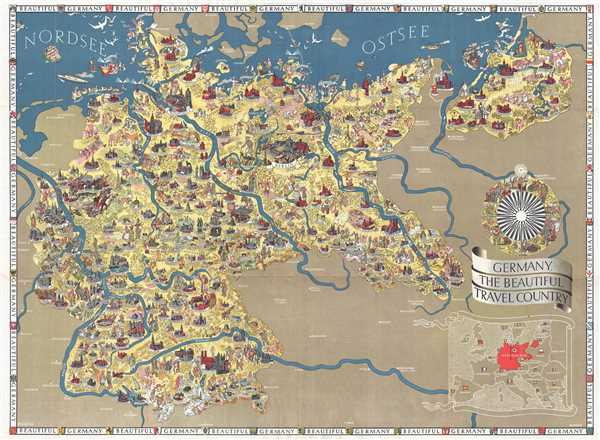
Germany, The Beautiful Travel Country.
1938 (undated) 22.25 x 30.5 in (56.515 x 77.47 cm) 1 : 1654000
1938 (undated) 22.25 x 30.5 in (56.515 x 77.47 cm) 1 : 1654000
Description
This is a 1938 Walter Riemer pictorial propaganda / tourist map of Nazi Germany. The map depicts Germany from its western border with France, Luxembourg, Belgium, and the Netherlands to its eastern border with Poland and from the North Sea to its southern border with Austria and Czechoslovakia. The most striking and disturbing (with the benefit of history) aspect of the map is the plethora of swastikas and Nazi flags. Nuremberg, for example, was home of the Congresses of the Nazi Party, and a phalanx of Brownshirts carrying a Nazi flag is illustrated there. Other cities marked by flags include Munich and Berlin, while ships in the North Sea near Schleswig fly the flag, along with two airships near Stolp in northwest Germany, and a procession of people, who appear to be on parade, near Hannover. Germany's borders on the map also do not reflect the land grabs and annexations of Austria and Czechoslovakia which occurred in 1938. The only indication of the conflagration to come is the presence of the Nazi flag.
The presence of that hateful symbol aside, the map is highly detailed and incredibly drawn. Numerous cities and towns throughout Germany are illustrated and labeled, usually according to their size and importance. Berlin is one of the most detailed, with the Brandenburg Gate and the Berlin Cathedral (Berliner Dom) easily recognizable. The Olympic Stadium for the 1936 Olympic Games which were held in Berlin is also rendered. Other cities include recognizable buildings or historical figures, such as an illustration of Martin Luther in Wittenberg and the Frauenkirche in Munich (Munchen). A gentleman with a wagon full of beer is also illustrated near Munich. Numerous other cities and towns include cathedrals and other buildings drawn in profile or a portrait of a famous citizen. Townspeople, peasants, and people on vacations are illustrated throughout the map, giving Germany the appearance of a welcoming and vibrant country. Livestock are included throughout the map, along with some wild animals, such as a moose near Tilsit. Outside of Germany, several cities in France, Austria, Czechoslovakia, and Poland are labeled such as: Vienna, Salzburg, and Innsbruck in Austria; Strasbourg, Besançon, Nancy, and Metz in France; Prague (Praha), and Bratislava in Czechoslovakia; and Warsaw and Poznań in Poland.
An inset map of Europe is situated in the lower right corner, with Germany (Deutschland) dominating the map in red. Each of the other countries in Europe is labeled by its German name and its flag. A border around the entire map repeats the phrase 'Beautiful Germany' and includes illustrations of the coats of arms of numerous German cities. Located above the inset map is an illustrated compass rose highlighting the achievements of German society.
On the verso, practical information for tourists is present in detail, describing the German 'Reich' and its cities, theatre, music, spas, and what money and visas are necessary when visiting Germany. Other information, pertaining to travel by train, plane, and automobile, is also included. A road map of Germany occupies a third of the verso, with smaller inset maps depicting Reich motor roads and the network of German airways in Europe. The verso also informs the reader that this map and more information are available for free from offices of the German Railways Information Bureau located in London, New York City, Chicago, San Francisco, and Toronto
This map was created by Walter Riemer and published by the Reichsbahn Center for German Tourist Traffic (Reichbahnzentrale für den Deutschen Reiseverkehr). We have been unable to find any references to this map in institutional collections.
Cartographer
Walter Riemer (1896 - 1942) was a German illustrator and painter. Riemer was active in Germany, producing political propaganda, advertising posters, stamps, bank notes, and other artwork, until 1942. He was a member of the Mitglied des Bundes Deutscher Gebrauchsgrafiker (Federation of German Commercial Artists). Riemer appears to have vanished (died?) at the start of World War II. More by this mapmaker...
Condition
Very good. Wear along original fold lines. Verso repairs to minor fold separations. Text and road map of Germany on verso.