This item has been sold, but you can get on the Waitlist to be notified if another example becomes available, or purchase a digital scan.
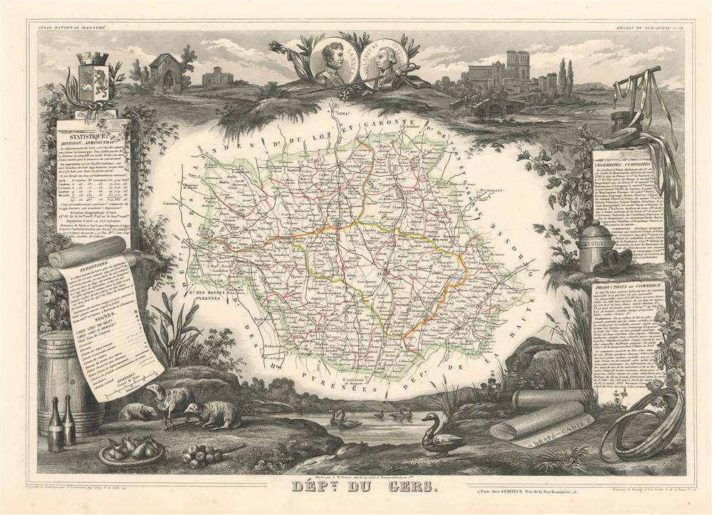
1852 Levasseur Map of the Department du Gers, France (Armagnac Region)
Gers2-levasseur-1852$75.00

Title
Dept. de Gers.
1852 (undated) 12.5 x 16.25 in (31.75 x 41.275 cm) 1 : 143164
1852 (undated) 12.5 x 16.25 in (31.75 x 41.275 cm) 1 : 143164
Description
This is a fascinating 1852 Victor Levasseur map of the department of Gers, France. This area of is known especially for its production of Armagnac Brandy and Floc de Gascogne, a sweet wine. It is also home to Côtes de Gascogne, a wine-growing district in Gascony producing white wine, and is also famous for its foie gras and wild mushrooms. The whole is surrounded by elaborate decorative engravings designed to illustrate both the natural beauty and trade richness of the land. There is a short textual history of the regions depicted on both the left and right sides of the map
Publication History and Census
This map was created and published by Victor Levasseur in the 1852 edition of his Atlas National de la France Illustrée. The illustrated border was drawn by Aristide Michel Perrot and Raimond Bonheur and the whole was engraved by E. George and Charles Smith.CartographerS
Victor Levasseur (1800 - 1870), an important French engineer, cartographer, and engraver of the mid 19th century, held a number of important cartographically related political and educations posts in France. He is most famous for his Atlas National Illustré des 86 Départements et des Possessions de La France, a large decorative atlas of France, including his Planisphere and five important continental maps. Levasseur's maps are distinctive for their wide decorative margins containing elaborate depictions of the scenery, peoples, and trade goods of the areas he mapped. Levasseur maps are also known to offer a wealth of statistical data. Until recently, very few Levasseur Atlases migrated out of France where they were mostly used in public libraries and town halls. His work represents some of the last great decorative atlases of the 19th century. More by this mapmaker...
Aristide Michel Perrot (1793 - 1879) was a French geographer, cartographer, and essayist active during the 19th century. Perrot specialized in miniature maps that appear in numerous French atlases. Perrot was also a prolific writer and his works include geographic lexicons and several essays. Learn More...
Source
Levassuer, V., Atlas National Illustre des 86 Departements et des Possessions de La France Divise par Arrondissements, Cantons et Communea avec La Trace de Toutes Les Routes, Chemins,de fer et Canaux., 1852 edition.
Condition
Very good. Even overall toning. Light foxing. Manuscript writing in pen in right margin. Blank on verso.
References
Phillips (Atlases) 3003.