This item has been sold, but you can get on the Waitlist to be notified if another example becomes available, or purchase a digital scan.
1720 De La Feuille Map and View of Gibraltar
Gibraltar-lafeuille-1720$487.50

Title
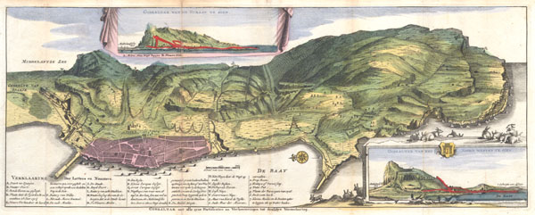
Gibraltar met alle zyne fortificatien en Verbeeteringen tot desselus Verzeekering.
1720 7 x 18.25 in (17.78 x 46.355 cm)
1720 7 x 18.25 in (17.78 x 46.355 cm)
Description
A very scarce, c. 1720, view format map of Gibraltar most likely prepared and issued by the De La Feuille family. Depicts the peninsula and town of Gibraltar from an east facing view perspective. The town of Gibraltar is well laid out with 31 important numbered locations throughout, all of which are referenced in a table below the map. Two additional views depict the promontory from different directions showing 'the Rock's' dramatic rise in elevation. In the lower right hand quadrant of the map numerous rabbits are drawn frolicking and sleeping around the inset. This likely a reference to the indigenous fauna of the promontory, which, given its rocky and barren situation, is limited to rabbits and other small mammals. We believe this to be the first edition of this map which was re-published in various formats throughout the 1720s and 1730s. Gibraltar is a rocky promontory on the southernmost extension of the Iberian Peninsula. Due to its strategic location at the entrance to the Mediterranean, it has long been a spot of military and political contention. Gibraltar was seized by British and Dutch troops during the 1704 Spanish War of Succession and in 1713 the Treaty of Utrecht, which ended the war, upheld the English claim. Cartographers and map publishers quickly capitalized on a general interest in the War and began advertize maps and plans of 'the Rock.' For want of good cartographic material, most of the publishers of the time, including Covens and Mortier, Henrich de Leth, and others, relied on reissues of this older map. This particular map seems to have been based stylistically upon the map drawn by Spaniard Don Luis Bravo Acuña in 1627. Both maps feature a similar view perspective as well as an east-facing orientation.
Cartographer
Daniel de La Feuille (1640 - 1709) was born of Huguenot stock in Sedan (L'Ardennes), France. As a young man he apprenticed as a watchmaker. In 1663 La Feuille married Charlette Marlet, the daughter of a local carpenter. Twenty years later, in 1683, facing religious prosecution of Huguenots in France, the family fled to Amsterdam. By 1686 Daniel had become a burgher (citizen) of the city and established himself as an engraver, publisher, and art dealer. Not long after, in 1691, he was admitted into the Booksellers Guild. Though we are primarily concerned with his cartographic work here, his masterpiece is considered to be Devises et emblems, a collection of symbols and designs mostly likely intended as templates for silversmiths, engravers, and watchmakers. His cartographic work includes numerous individual maps and atlases, many of which continued to be published and republished well after his death in 1709. He was succeeded by his sons Jacob de la Feuille (1668 - 1719) and Paul de La Feuille (1688 - 1727). More by this mapmaker...
Condition
Very good condition. Minor discoloration along the original folds – see photo. Minor fold reinforcement and repair. Original plate-mark visible. There seems to be some red coloration delineating the area of fortificaiton along the shore of Gibraltar in both insets. This is does not appear in only other copy we’ve found, in the Institut Cartogràfic de Catalunya. However, it does appear to be original older color. Else clean and beautiful.
References
Institut Cartogràfic de Catalunya, RM.27285. Finlayson, Clive; Fa,Darren; The Fortifications of Gibraltar 1068-1945, page 21.