This item has been sold, but you can get on the Waitlist to be notified if another example becomes available, or purchase a digital scan.
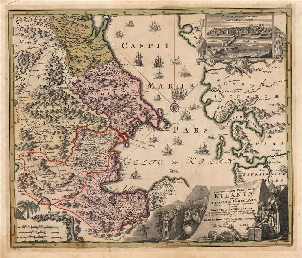
1728 Homann map of Azerbaijan and the Persian-Russia Frontier
Gilan-homann-1728$425.00

Title
Provinciarum Persicarum Kilaniae nempe Chirvaniae Dagestaniae.
1728 (dated) 19 x 23 in (48.26 x 58.42 cm) 1 : 2000000
1728 (dated) 19 x 23 in (48.26 x 58.42 cm) 1 : 2000000
Description
This map, printed by Johann Baptist Homann and published by his son Johann Christoph Homann, focuses on the Caucuses, now occupied by modern-day Dagestan, Azerbaijan, Armenia, and Iran, on the western coast of the Caspian Sea. The inset view at the upper right depicts Terek, which appears on the map at its northern extent. This was the main outpost of the Terek Cossacks, Russia's vassals on the Empire's Caucasus frontier.
The title cartouche, framed against a caravan tent, depicts a silk-robed Persian merchant conversing with a Persian soldier. In the background is a caravan of heavily-laden camels and horses. In the foreground are a pair of dogs: symbols of vigilance and loyalty, they may allude to Russian or Persian vassal states in the region, guarding the borders of their respective empires.
The Map's Sources
The map's western detail is largely derived from the reports and maps of Adam Olearius, who between 1633 and 1639 journeyed with an embassy to Muscovy and Persia. Olearius' party traveled down the Volga by boat and continued that way along the western shore of the Caspian Sea to the province of Gilan and the city of Rasht, in Persia. Olearius' work provided the best 17h century European mapping of the Volga River and the Caspian Sea, which would not be supplanted until well into the 18th century, providing the model even for Russian maps of this frontier. The eastern shore, however, reflects much more current knowledge: the 1719-1721 charting of the Caspian Sea by Karl Van Verden. Also, the roads indicated linking the region's cities do not appear on Olearius' original maps, however they do appear on De l'Isle's 1723 map of the Caucasus. It is interesting to note that neither Van Verden's charting of the southwestern Caspian nor that of De l'Isle has here replaced that of Olearius, whose detail Homann seems reluctant to abandon.Impetus for This Map
The present work displays those territories of the Caucasus that were captured from Safavid Iran by Tsar Peter I during the 1722-23 Second Russo-Persian war: Dagestan, Shirvan and Gilan. These Russian gains would not last - Peter's successor Anna Ioannovna returned the territories to Persia in the 1732 Treaty of Resht.Armenia
Armenia is marked here as a province of Iran - despite its having been predominantly occupied by the Ottoman Empire from 1623 to 1730. Yerevan (Erivan here) appears at the western edge of the map. In the Armenian mountains at the border with Georgia, Mount Ararat is named, and Noah's Ark is at on its peak.Decorative Engraving
As is frequently the case with Homann maps, the present work is rich in descriptive illustration. This extends to the topographical illustration: the region's mountainous terrain is indicated pictorially. The scale cartouche in the lower left is framed with palm trees and vineyards. The view of Terek is framed with two Circassian Tatars (identified by the sheep sacrifice mounted on a pike, a custom described by Olearius in his book). The base of the image is decorated with spears, arrows, scimitars, and axes, to emphasize the military nature of the post.The title cartouche, framed against a caravan tent, depicts a silk-robed Persian merchant conversing with a Persian soldier. In the background is a caravan of heavily-laden camels and horses. In the foreground are a pair of dogs: symbols of vigilance and loyalty, they may allude to Russian or Persian vassal states in the region, guarding the borders of their respective empires.
Publication History and Census
This map was engraved by Ruprecht Adam Schneider in 1728 for inclusion in the Homann atlases. The separate map is well represented in institutional collections and appears occasionally on the market.CartographerS
Johann Baptist Homann (March 20, 1664 - July 1, 1724) was the most prominent and prolific map publisher of the 18th century. Homann was born in Oberkammlach, a small town near Kammlach, Bavaria, Germany. As a young man, Homann studied in a Jesuit school and nursed ambitions of becoming a Dominican priest. Nonetheless, he converted to Protestantism in 1687, when he was 23. It is not clear where he mastered engraving, but we believe it may have been in Amsterdam. Homann's earliest work we have identified is about 1689, and already exhibits a high degree of mastery. Around 1691, Homann moved to Nuremberg and registered as a notary. By this time, he was already making maps, and very good ones at that. He produced a map of the environs of Nürnberg in 1691/92, which suggests he was already a master engraver. Around 1693, Homann briefly relocated to Vienna, where he lived and studied printing and copper plate engraving until 1695. Until 1702, he worked in Nuremberg in the map trade under Jacob von Sandrart (1630 - 1708) and then David Funck (1642 - 1709). Afterward, he returned to Nuremberg, where, in 1702, he founded the commercial publishing firm that would bear his name. In the next five years, Homann produced hundreds of maps and developed a distinctive style characterized by heavy, detailed engraving, elaborate allegorical cartouche work, and vivid hand color. Due to the lower cost of printing in Germany, the Homann firm could undercut the dominant French and Dutch publishing houses while matching their diversity and quality. Despite copious output, Homann did not release his first major atlas until the 33-map Neuer Atlas of 1707, followed by a 60-map edition of 1710. By 1715, Homann's rising star caught the attention of the Holy Roman Emperor Charles VI, who appointed him Imperial Cartographer. In the same year, he was also appointed a member of the Royal Academy of Sciences in Berlin. Homann's prestigious title came with several significant advantages, including access to the most up-to-date cartographic information as well as the 'Privilege'. The Privilege was a type of early copyright offered to very few by the Holy Roman Emperor. Though less sophisticated than modern copyright legislation, the Privilege offered limited protection for several years. Most all J. B. Homann maps printed between 1715 and 1730 bear the inscription 'Cum Priviligio' or some variation. Following Homann's death in 1724, the firm's map plates and management passed to his son, Johann Christoph Homann (1703 - 1730). J. C. Homann, perhaps realizing that he would not long survive his father, stipulated in his will that the company would be inherited by his two head managers, Johann Georg Ebersberger (1695 - 1760) and Johann Michael Franz (1700 - 1761), and that it would publish only under the name 'Homann Heirs'. This designation, in various forms (Homannsche Heirs, Heritiers de Homann, Lat Homannianos Herod, Homannschen Erben, etc.) appears on maps from about 1731 onwards. The firm continued to publish maps in ever-diminishing quantities until the death of its last owner, Christoph Franz Fembo (1781 - 1848). More by this mapmaker...
Adam Olearius, or Ölschläger (September 24, 1599 – February 22, 1671) was a German scholar, mathematician, geographer and librarian. He is best known for his published reports of his travels to Safavid Persia. He was educated in Leipzig; after his studies he became librarian and court mathematician to Frederick III, Duke of Holstein-Gottorp. In 1633, he was appointed secretary to the Duke's embassy to Muscovy and Persia. Although the embassy - meant to establish the Duke's city of Friedrichstadt as the European terminus of a prospective overland silk route - was only partially successful, the embassy's journey down the Volga and to the Caspian Sea provided Olearius with the basis for some of the earliest descriptions of those regions based on actual observation; Olearius was responsible for the introduction of much of Persian literature and culture to Europe for the first time. On his return, the Duke made Olearius his librarian and keeper of his cabinet of curiosities - a wise choive, as under his curation the Gottorp library and cabinet were greatly enriched in manuscripts, books, and works of art. Learn More...
Ruprecht Adam Schneider (fl. 1727-1760), also known as R.A.S. or Schneider the Younger, was a German engraver and artist who engraved for Johann Baptist and Johann Christoph Homann. As with many engravers, his education and life details are obscure. Learn More...
Source
Homann, J. B. and Homann, J. C., Neuer Atlas bestehend in einig curieusen Astronomischen Kuppren und vielen auserlesenen accuratensten Land-Charten über die Gantze Welt, (Nuremberg: Homann), 1728.
Homann's Neuer Atlas bestehend in einig curieusen Astronomischen Kuppren und vielen auserlesenen accuratensten Land-Charten über die Gantze Welt was first publihsed in 1707 with 33 maps. A second edition followed in 1710 with 60 maps. Subsequent editions followed until about 1730. The title page notes proudly that the atlas features measurements based on the 'Copernican principle of the moving sky', a truly state-of-the-art innovation for the period. Regardless of editions, collations of the atlas are inconsistent, with some examples having less, while others have more maps - a consequence of the fact that the map sheets were delivered loose, to be bound at the buyer's discretion, and so some buyers chose to omit maps they did not consider relevant, or add others they did. Between editions, the constituent maps, particularly of European regions, were regularly updated to reflect the most recent political events. The atlas continued to be published by Homann's son, J. C. Homann (1703 - 1730), and then by Homann Heirs. Most examples also feature a fine allegorical frontispiece with the title Atlas Novus Terrarum Orbis Imperia, regna et Status, which was used for multiple Homann atlases, including the Neuer Atlas and the Atlas Minor.
Condition
Very good. Faint toning. Generous margins with deckled edge at top. Original wash and outline color.
References
OCLC 82161560.