1890 U. S. Geological Survey Map of Gloucester and Rockport, Massachusetts
Gloucester-usgs-1890$150.00
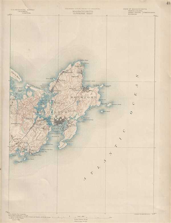

Title
Massachusetts. Gloucester sheet.
1890 (dated 1886) 20 x 15 in (50.8 x 38.1 cm) 1 : 62500
1890 (dated 1886) 20 x 15 in (50.8 x 38.1 cm) 1 : 62500
Description
This is a lovely example of the 1890 U.S. Geological Survey map of Cape Ann. Extends eastward from Manchester and Essex to include Gloucester, Rockport, Lanesville and Annisquam. Offers copious topographical detail as well as some submarine detail as well as towns, railroads, streams, and some individual buildings. This map was based on surveys in 1886 conducted by chief Geographer Henry Gannett. Geographer in charge was Marcus Baker and triangulation and coast line by the U.S. Coast and Geodetic and Borden surveys. Topography by E.W.F. Natter. Updated to 1890.
Cartographer
The Office of the Coast Survey (later the U.S. Geodetic Survey) (1807 - present), founded in 1807 by President Thomas Jefferson and Secretary of Commerce Albert Gallatin, is the oldest scientific organization in the U.S. Federal Government. Jefferson created the "Survey of the Coast," as it was then called, in response to a need for accurate navigational charts of the new nation's coasts and harbors. The first superintendent of the Coast Survey was Swiss immigrant and West Point mathematics professor Ferdinand Hassler. Under the direction of Hassler, from 1816 to 1843, the ideological and scientific foundations for the Coast Survey were established. Hassler, and the Coast Survey under him developed a reputation for uncompromising dedication to the principles of accuracy and excellence. Hassler lead the Coast Survey until his death in 1843, at which time Alexander Dallas Bache, a great-grandson of Benjamin Franklin, took the helm. Under the leadership A. D. Bache, the Coast Survey did most of its most important work. During his Superintendence, from 1843 to 1865, Bache was steadfast advocate of American science and navigation and in fact founded the American Academy of Sciences. Bache was succeeded by Benjamin Pierce who ran the Survey from 1867 to 1874. Pierce was in turn succeeded by Carlile Pollock Patterson who was Superintendent from 1874 to 1881. In 1878, under Patterson's superintendence, the U.S. Coast Survey was reorganized as the U.S. Coast and Geodetic Survey (C & GS or USGS) to accommodate topographic as well as nautical surveys. Today the Coast Survey is part of the National Oceanic and Atmospheric Administration or NOAA. More by this mapmaker...
Condition
Very good. Minor foxing.
References
Rumsey 2883.044.