
1950 AAR Pictorial Railroad Map of North America


This item has been sold.
Going Places by Rail From the Atlantic to the Pacific, from Canada to Mexico, Stretches the Vast Network of American Railroads.
Choose a Collection:
- Digital Map Information
- Suitable for large format printing
- Full resolution TIFF file
- ICC color profile embedded
- Delivered instantly via download link
This Item
Enquire
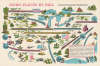
This is a c. 1950 promotional infographic map of North America prepared by the Association of American Railroads. It is designed to emphasize North American rail integration and represents a brave stab at optimism as trains were being displaced by automobiles and airplanes for both freight and passenger purposes.
The organization's true 'trial by fire' came during World War II, where it advocated for the efficacy of public-private coordination over government seizure (as had happened during the First World War). The AAR successfully coordinated the movement of approximately 90% of all military freight and 97% of military personnel within the United States. As the industry moved toward 1950, the AAR shifted its focus toward massive technological modernization. This era was defined by the aggressive transition from steam to diesel-electric power and the implementation of standardized safety and mechanical protocols, ensuring that rail infrastructure could handle the demands of the post-war industrial boom.
A Closer Look
This striking image loosely takes the form of a map, with no borders or placenames, though the Great Lakes are instantly recognizable. Some other features can also be identified without much difficulty, including the Atlantic coastline, the Rocky Mountains, and the Appalachian Mountains. Illustrations are used to denote different cities and regions, including the skylines of New York and Chicago, the Golden Gate Bridge for San Francisco, and the White House for Washington, D.C. Old Faithful, the Alamo, and a Mardi Gras jester also make appearances. The river at left may refer to the Colorado River, while the nearby giant trees of California and the Pacific Northwest represent those regions. Running between all these destinations are the streamlined trains - 'marvels of beauty, comfort, and speed' - of the AAR member railroads, including the Canadian Pacific at top (curiously marked by a Union Jack rather than Red Ensign flag used by Canada before the 1965 adoption of the current maple leaf design). Though the AAR was founded to advocate for freight rail, its writ expanded over time, and this piece is primarily aimed at potential passengers to convince them of the benefits of travel by rail.The Association of American Railroads
The Association of American Railroads (AAR) is an industry trade group for freight rail established on October 12, 1934, emerging as a unified voice for an industry struggling through the depths of the Great Depression. It was formed by the merger of five industry groups, most notably the American Railway Association and the Association of Railway Executives, to which were later added additional regional freight and passenger railroads, including those in Canada and Mexico. The consolidation was largely a strategic response to the federal government's increasing regulatory pressure and the appointment of a Federal Coordinator of Transportation. By centralizing research, legal advocacy, and operational standards, the AAR aimed to improve the efficiency and financial stability of the private rail sector at a time when burgeoning competition from the trucking industry and personal automobiles began to threaten its dominance.The organization's true 'trial by fire' came during World War II, where it advocated for the efficacy of public-private coordination over government seizure (as had happened during the First World War). The AAR successfully coordinated the movement of approximately 90% of all military freight and 97% of military personnel within the United States. As the industry moved toward 1950, the AAR shifted its focus toward massive technological modernization. This era was defined by the aggressive transition from steam to diesel-electric power and the implementation of standardized safety and mechanical protocols, ensuring that rail infrastructure could handle the demands of the post-war industrial boom.
Publication History and Census
This map is undated and unattributed, but can be assumed to have been produced by the AAR, which put out several other similar infographics in the 1950s ('How Railroads Work,' 'Railroads and American Life,' Railroads and World Trade'). Some of these are attributed and accompanied by mock questions for students, suggesting an intended classroom use, though the present map appears to be a promotional work for a more general audience. We have not been able to locate any examples of this map in institutional collections.Condition
Fine.