1893 Trekking Map of Gosainkund and Helambu in Nepal
GosainkundTrek-npmaf-1983$550.00

Title
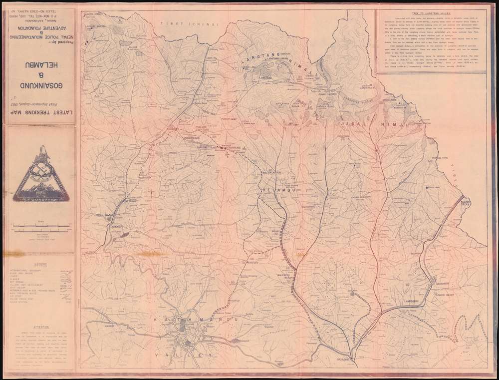
Latest Trekking Map First Impression August 1983 Gosainkund and Helambu.
1983 (dated) 26.25 x 34.5 in (66.675 x 87.63 cm) 1 : 100000
1983 (dated) 26.25 x 34.5 in (66.675 x 87.63 cm) 1 : 100000
Description
This is a 1983 Nepal Police Mountaineering and Adventure Foundation cyanotype map of the trekking routes from Kathmandu to Gosainkunda lake in Nepal's Langtang National Park, and the Helambu region. Gosainkunda, in particular, is a place of great religious significance, and is a major pilgrimage destination.
The cyanotype map shows rivers and bridges, lakes glaciers, hot springs, villages and towns, passable roads, as well as air strips, police stations and check posts. The map covers the region between the Tibetan border and Kathmandu, and is peppered with hundreds of settlements - many too small to be named. The mountainous topography is shown with great detail, using gradients and altitudes above sea level.
The cyanotype map shows rivers and bridges, lakes glaciers, hot springs, villages and towns, passable roads, as well as air strips, police stations and check posts. The map covers the region between the Tibetan border and Kathmandu, and is peppered with hundreds of settlements - many too small to be named. The mountainous topography is shown with great detail, using gradients and altitudes above sea level.
Cyanotype: Why so Blue?
Cyanotype is a photo-reprographic technique developed in 1842 by the British astronomer John Herschel (1792 - 1871). Sometimes called a 'sunprint', the technique employs a solution of ferric ammonium citrate and potassium ferricyanide, which painted on white paper or cloth, reacts when exposed to sunlight to dye the object a brilliant blue. Areas blocked from ultraviolet exposure remain undyed and white. Herschel developed the technique to reproduce his astronomical notes, but others quickly realized that any object capable of blocking light could be used to quickly and easily create a cyanotype image. By the late 19th century the process became popular with designers, military, architects, and engineers (blueprints), who used the cheap an effective technique to quickly and exactly reproduce images in the field. Cyanotyping is limited in that only a single copy can be made at one time, so it was only practical for short-term field work. It is also of note that cyanotypes remain extremely reactive to light and, over time, fade or degrade, making them extremely ephemeral. The process fell out of fashion in most places by the 1920s, but remains in use in some parts of the world, such as India and Nepal, to this day.Publication History and Census
This map was printed in 1983 by the Nepal Police Mountaineering and Adventure Foundation. While it is not known how many were produced, the mimeograph printing process used was not conducive to long print runs. While we are aware of other maps printed by the NPMAF in price records and institutional collections, we see no other examples of this one. There are no listings of it in OCLC.Cartographer
The Nepal Police Mountaineering and Adventure Foundation was established by Nepalese Police Inspector General Khadgajeet Baral in about 1977 in order to establish mountaineering regimes for Nepali police officials, and to promulgate both mountain conservation and mountaineer rescue services. The NPMAF produced a series of trekking maps in the 1980s, sold in order to support these activities. More by this mapmaker...
Condition
Good condition. Toning of mimeographed image at folds, some mended wear at junctures.
References
Not in OCLC