This item has been sold, but you can get on the Waitlist to be notified if another example becomes available.
1933 Jo Mora Pictorial Map of Central America / The Spanish Main
GraceLine-mora-1933-3$720.00


Title
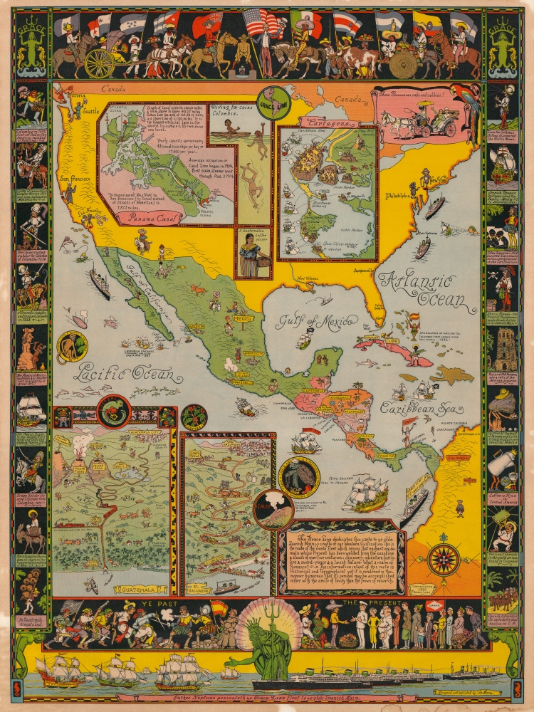
Father Neptune presenteth ye Grace Line fleet to ye olde Spanish Main.
1933 (dated) 31.25 x 23.25 in (79.375 x 59.055 cm) 1 : 12200000
1933 (dated) 31.25 x 23.25 in (79.375 x 59.055 cm) 1 : 12200000
Description
This is a rare 1933 Jo Mora pictorial map of Central America commissioned by the Grace Line to celebrate and advertise its newly-launched passenger service from New York City to Seattle via the Panama Canal. Centered on Central America, the map depicts North, Central, and South America and focuses on ports of call of the Grace Line. The whole is dedicated to the memory of the Spanish Main, which is referred to as the 'cradle of our Western Civilization'. Mora also includes a disclaimer of sorts just below this dedication, stating
From Havana, a Grace Line cruise proceeded to Puerto Colombia, before heading to Cristobal, Costa Rica, and the trip through the Panama Canal, marked by Uncle Sam holding a banner reading 'CANAL.' After transiting the isthmus, passengers were treated to stops in Balboa and Puntarenas, Costa Rica; La Libertad, El Salvador; San Jose, Guatemala; and Mazatlán, Mexico, before arriving in Los Angeles, California. The steamer then continued to San Francisco, and Victoria, British Columbia, before finally arriving in Seattle, Washington. The comical personifications of these cities resume in Los Angeles, where a movie director is filming smiling angels. A Franciscan monk personifies San Francisco, while a young woman (presumably named Victoria…) waves from Victoria across the Salish Sea to a cowboy in Seattle.
Two insets situated along the bottom border illustrate Guatemala and El Salvador. San Jose de Guatemala is located on the left, with locals riding horses, an active volcano, and Guatemala City farther inland. La Libertad, El Salvador is on the right and the road between La Libertad and San Salvador is the main focal point.
The informative intent of this carte is Historical and Topographical yet it is rendered in the manner humorous that its perusal may be accomplished rather with the smile of levity than the frown of research.
The Grace Line Itinerary
From New York or Seattle, a Grace Line cruise took three weeks. Passengers were encouraged to explore cities en route, and 'conducted excursions' were offered, for a small cost. Nearly all the waypoints along the route are highlighted by pictorial vignettes, as are several other locations. Starting in New York, both New York City and Philadelphia are marked by men in 18th-century garb. Two cruise liners appear on the coast, one heading south and the other north. The next port of call is Havana, Cuba, personified by a man smoking a Churchill-sized cigar. Mora also includes an illustration of Christopher Columbus on tiny Watling Island, not far off the coast of Cuba, holding a Spanish flag and a sword to commemorate his 1492 landing in the New World.From Havana, a Grace Line cruise proceeded to Puerto Colombia, before heading to Cristobal, Costa Rica, and the trip through the Panama Canal, marked by Uncle Sam holding a banner reading 'CANAL.' After transiting the isthmus, passengers were treated to stops in Balboa and Puntarenas, Costa Rica; La Libertad, El Salvador; San Jose, Guatemala; and Mazatlán, Mexico, before arriving in Los Angeles, California. The steamer then continued to San Francisco, and Victoria, British Columbia, before finally arriving in Seattle, Washington. The comical personifications of these cities resume in Los Angeles, where a movie director is filming smiling angels. A Franciscan monk personifies San Francisco, while a young woman (presumably named Victoria…) waves from Victoria across the Salish Sea to a cowboy in Seattle.
The Map's Many Insets
Four inset maps provide detailed views of Grace Line voyage stops. Moving from left to right, the first inset is a detailed depiction of the Panama Canal. Each section of locks is illustrated, as is the Panama Railroad which runs along the Canal from Colon to Balboa. A second inset map of Cartagena illustrates the city's historic fortresses being shelled, and responding in kind, by a fleet of men-of-war. Two insets separate the two maps. One depicts a Colombian diving for coins and the other is a portrait of a Guatemalan coffee picker. An illustration of the Grace Line logo is also included.Two insets situated along the bottom border illustrate Guatemala and El Salvador. San Jose de Guatemala is located on the left, with locals riding horses, an active volcano, and Guatemala City farther inland. La Libertad, El Salvador is on the right and the road between La Libertad and San Salvador is the main focal point.
The Pictorial Border
While the central map is delightful, Mora's talent for comic illustration is evident in the border as well. A parade of nations occupies the top border, with Uncle Sam and the American flag at the center. An American World War I soldier, a 'doughboy' is illustrated straddling the Panama Canal to the left of Uncle Sam, while people from North, Central, and South America meet in the middle, with Canada and Mexico flanking Uncle Sam. Vignettes of historical events create the side borders, illustrating Christopher Columbus, Hernan Cortes, Francis Drake, and Simon Bolivar. Mora also references the slave trade, Caribbean piracy, the Mayans, and the bloody wars in Colombia and El Salvador. The past and the present meet along the bottom, where conquistadors and pirates fight to the death while civilized travelers on a Grace Line voyage meet and shake hands with locals. Perhaps the most charming element of the entire map, however, is situated along the very bottom. Here, Mora has placed Neptune introducing the Grace Line fleet to the frigates and men-of-war of the Spanish Main.Publication History and Census
This map was created by Jo Mora and published by Grace Line in 1933. We note two examples cataloged in OCLC which are part of the collections at the Newberry Library and the California Historical Society. A third cataloged example is part of the David Rumsey Map Collection at Stanford University. Rare to the market.Cartographer
Joseph 'Jo' Jancito Mora (October 22, 1876 – October 10, 1947) was an Uruguayan born artist active in California during the first half of the 20th century. Mora immigrated to California as a young man. He studied art in Boston and, after graduating, worked there briefly before relocating to California. In cartographic circles Mora is known for pioneering the 20th century pictorial map. In a series he referred to as his 'cartes,' published between in 1926 and 1942, Mora developed a pictorial style that combined cartography with colorful cartoonish image of local figures, folklore, history, and natural wonders. His earliest maps were commissioned by the Hotel Del Monte and included California's Playground and The Seventeen Mile Drive. As he matured as a cartographer, his work became increasingly dense, often packed with tiny figures, each expressive of some aspect of regional life. Mora, often called the 'Renaissance man of the West' also worked as an illustrator, muralist, sculptor, photographer, and writer. His masterpiece is considered to be the Father Serra Cenotaph, a bronze and marble sculpture at the Memorial Chapel in El Carmelo Mission, Carmel, California. His map work included Monterey Penninsula (1927), and Seventeen Mile Drive (1927), California (1927), Grand Canyon (1931), Yosemite (1931), Yellowstone (1936), Carmel-By-The-Sea (1942), California (1945) (large and small versions), Map of Los Angeles (1942), among others. More by this mapmaker...
Condition
Very good. Minor dampstaining bottom margin. Other minor margin spotting.
References
Rumsey 8592.000. OCLC 857306665.