This item has been sold, but you can get on the Waitlist to be notified if another example becomes available, or purchase a digital scan.
1741 Homann Heirs Map of Ancient Greece & the Eastern Mediterranean
Graecia-homannheirs-1741$250.00

Title
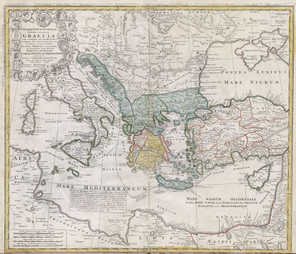
Imperii Turcici Europaei Terra, in primis Graecia cum consiniis ad intelligendos Scriptores N.T. ceterospue graecos et latinos accomodata, In Usum Principis Iuventutis in heredem nati, Ducis Brunsuico - Luneburgi Caroli Wilhelmi Ferdinandi ad ornavit Ioannes Christoph Harenberg. Gen. Sch Insp. et Reg Scient, Societ Berol. Sodal. Curantibus Homannianis Heredibus. A. 1741 cu. Arivil. S. C.M.
1741 20 x 24 in (50.8 x 60.96 cm)
1741 20 x 24 in (50.8 x 60.96 cm)
Description
This is one of the Homann Heirs finest and most appealing maps of the ancient Greek World. Map centers on Greece but includes the entirety of the eastern Mediterranean and North Africa. Also includes the Black Sea as far as the Crimea and the sea of Azov. Extends north as far as Sarmatia and Pannonia. Includes Italy, Sicily, Corsica and Sardinia. Upper left quadrant features a decorative title cartouche adorned with the rectos and versos of 12 ancient Greek coins with explanatory numbered references outside the top border of the map. Show the important Greek provinces and colonies through the Mediterranean, especially in modern day turkey and in the Italian peninsula. Includes nautical military and trade routes. This map was drawn by Joanes Christoph Harenberg for inclusion the 1752 Homann Heirs Maior Atlas Scholasticus ex Triginta Sex Generalibus et Specialibus…. Most early Homann atlases were 'made to order' or compiled of individual maps at the request of the buyer. However, this rare atlas, composed of 37 maps and charts, was issued as a 'suggested collection' of essential Homann Heirs maps. A fine copy of an important map.
Cartographer
Homann Heirs (1730 - 1848) were a map publishing house based in Nuremberg, Germany, in the middle to late 18th century. After the great mapmaker Johann Baptist Homann's (1664 - 1724) death, management of the firm passed to his son Johann Christoph Homann (1703 - 1730). J. C. Homann, perhaps realizing that he would not long survive his father, stipulated in his will that the company would be inherited by his two head managers, Johann Georg Ebersberger (1695 - 1760) and Johann Michael Franz (1700 - 1761), and that it would publish only under the name 'Homann Heirs'. This designation, in various forms (Homannsche Heirs, Heritiers de Homann, Lat Homannianos Herod, Homannschen Erben, etc..) appears on maps from about 1731 onwards. The firm continued to publish maps in ever diminishing quantities until the death of its last owner, Christoph Franz Fembo (1781 - 1848). More by this mapmaker...
Condition
Very Good condition. Very minor centerfold discoloration. Blank on verso. Bottom margin narrow, as issued.
References
Phillips, Lee Philip, A List of Geographical Atlases in the Library of Congress, Page 157.