1866 Holmes Map of Gramercy, Rose Hill, and Kips Bay, Manhattan, New York City
Gramercy-holmes-1866$3,000.00

Title
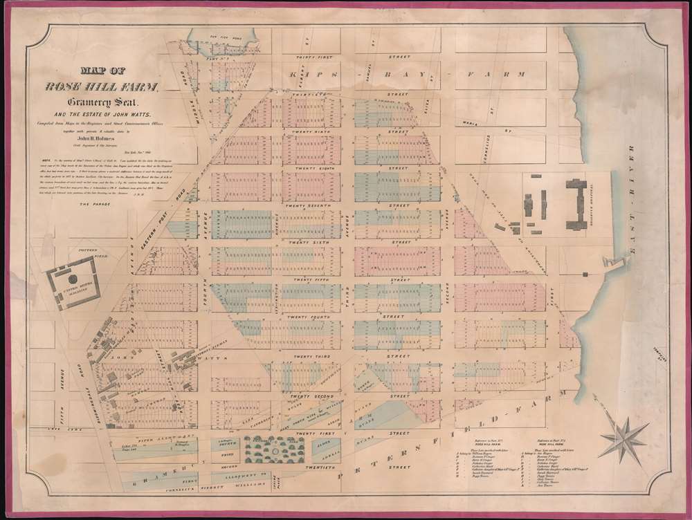
Map of Rose Hill Farm, Gramercy Seat, and the estate of John Watts.
1866 (dated) 23 x 31 in (58.42 x 78.74 cm) 1 : 1860
1866 (dated) 23 x 31 in (58.42 x 78.74 cm) 1 : 1860
Description
This is a John Bute Holmes 1866 cadastral map of parts of the Gramercy, Rose Hill, and Kips Bay neighborhoods in the borough of Manhattan in New York City.
Holmes became fascinated by the early history of Manhattan real estate ownership, recognizing the wealth to be accrued by accurately understanding the history of city land ownership, division, and inheritance. Moreover, Holmes allied himself with the corrupt Tweed administration, assuring himself and his allies even greater wealth and political power from the eminent domain seizure of old Manhattan estates. Holmes created a series of maps, reminiscent of John Randall's 'Farm Maps', overlaid with property data, showing the borders of old estates, and notating the breakup of the lands among various heirs. The complex work of compiling the maps earned Holmes a fortune, with one newspaper suggesting on his death in 1887 that some of his individual maps were worth more than 30,000 USD. There is no complete carto-bibliography of Holmes' maps, but we believe there to be at least 50 of them, possibly more.
A Closer Look
The map depicts the city from Fifth Avenue to the East River and from Thirty-First Street to Twentieth Street and Gramercy Park. Holmes superimposed the neighborhood's historical streets and residences over the contemporary grid system. The modern city blocks created by the 1811 Commissioner's Plan are separated into neat lots, all of which are numbered. However, the older overprinted streets and the property lines pay little heed to the organization imposed by the Commissioner's Plan. Allotments and leased plots of land branch out from Bloomingdale Road in the lower left quadrant, where Rose-Hill Street cuts through several of the Commissioner's blocks. Bellevue Hospital is situated on the banks of the East River, as it is today. Older streets, including Cornelius Street, Maria Street, and Eliza Street, are ghosted in over the grid.Rose Hill Farm
Rose Hill Farm was originally acquired by the Honorable John Watts (1715 - 1789) from James DeLancey (November 27, 1703 - July 30, 1760) in November 1747. Containing over 130 acres, the farm occupied land that today stretches from 21st to 30th Street and from Fourth Avenue to the East River. Watts, a Loyalist, and his family left for Britain in 1775 and left the farm in the hands of his son John Watts Jr (1749 - 1836). The younger Watts eventually inherited the farm and his father's house on Broadway in 1789 after his father's death. The main house on the property burned in 1779 during the British occupation, but a deed records, 'houses, buildings, orchards, and gardens' on the property in the 1780s. Pieces of the farm began to be sold off in the 1780s, and the rest of the property was listed for sale in 1790. It was acquired by Revolutionary War General Horatio Gates, who built a country estate with a mansion at the corner of today's Second Avenue and Twenty-Second Street. When Gates died in 1806, the mansion was turned into a boarding house. What was left of the estate had been divided into lots by the time of the 1811 Commissioner's Plan.Holmes' 'Farm Maps'
In the early 19th century, most of Manhattan was undeveloped farmlands, the property of wealthy landowners with claims dating to the Dutch period of New York's history. The northern 2/3rd of Manhattan was dotted with farmlands and sprawling gentlemanly estates, many with great manor houses overlooking the Hudson River. The Commissioner's Plan of 1811 and the 1807 Commission Law laid the street grid through many of these properties and gave the city the right to claim these lands under eminent domain, providing due compensation to the landowners. While this work occurred early in lower Manhattan, central and upper Manhattan were not formally acquired by the city until the mid-19th century.Holmes became fascinated by the early history of Manhattan real estate ownership, recognizing the wealth to be accrued by accurately understanding the history of city land ownership, division, and inheritance. Moreover, Holmes allied himself with the corrupt Tweed administration, assuring himself and his allies even greater wealth and political power from the eminent domain seizure of old Manhattan estates. Holmes created a series of maps, reminiscent of John Randall's 'Farm Maps', overlaid with property data, showing the borders of old estates, and notating the breakup of the lands among various heirs. The complex work of compiling the maps earned Holmes a fortune, with one newspaper suggesting on his death in 1887 that some of his individual maps were worth more than 30,000 USD. There is no complete carto-bibliography of Holmes' maps, but we believe there to be at least 50 of them, possibly more.
Publication History and Census
This map was created and published by John Bute Holmes in 1866. Three examples are recorded in the OCLC and are part of the collections at Princeton University, the New York State Library, and Harvard. Although uncatalogued, we believe that the New York Public Library also has an example.Cartographer
John Bute Holmes (March 31, 1822 - May 21, 1887) was an Irish civil engineer, city surveyor, and mapmaker based in New York City in the middle to latter 19th century. Holmes was described as a 'short, stout man, with curly gray hair, a smooth face, and a short, thick neck.' Holmes' father-in-law supplied funds for him to immigrate to America in 1840 and shortly thereafter, in 1844, he established himself in New York City. He briefly returned to Europe before once again settling in New York City in 1848. Apparently, according to several New York Times articles dating to the 1870s, Holmes was a man of dubious personal and moral character. He was involved in several legal disputes most of which were associated with his outrageous - even by modern standards - womanizing. In 1857 he was convicted of forgery of a marriage document and sentenced to 15 years of hard labor at Sing Sing, of which he served 5 before wealthy associates interceded on his behalf for an early release. Holmes seems to have been married to several different women at the same time and to have had an unfortunate attraction to exceptionally young women - one of whom, 16 year old May Chamberlayne claimed to be his wife and sued him for 50,000 USD. On another occasion he was found guilty of killing Brooklyn policeman David Gourly with whose wife he 'had been intimate.' Another woman, Miss Abrams, who he hired as a housekeeper, was repeatedly attacked by Holmes and ultimately driven to madness and was consigned to Bellevue Hospital, where she died. Although he attempted to flee the country rather than face conviction for 4th degree manslaughter, he was ultimately arrested and served one year in prison. During the American Civil War he ran for Alderman of the First Ward, in New York. Despite his legal issues, Holmes was a man of considerable means, with a personal fortune estimated between 100,000 and 500,000 USD - a significant sum in the late 19th century. Much of his wealth is associated with a series of important cadastral maps produced between 1867 and 1875 while he was employed as a surveyor and civil engineer under the corrupt Tweed regime. When Holmes died of an 'apoplectic fit' there was considerable wrangling over his estate among his 7 heirs and 11 children. The cream of his estate where his maps, some of which were valued at more than 30,000 USD in 1887. Holmes lived on a large farm-estate in Fanwood New Jersey. More by this mapmaker...
Condition
Good. Linen backing refreshed. Silk edging. Minor water stains. Minor loss reinstated left margin.
References
OCLC 50565224.